Airborne multispectral imaging system with integrated navigation sensors and automatic image stitching

a multi-spectral imaging and navigation sensor technology, applied in image enhancement, radiation control devices, instruments, etc., can solve the problems of insufficient resolution of landsat images, crop damage affecting the reflectance of leaves, and relatively long time period (weeks) between, so as to achieve high-speed, on-demand scan of the field, and precise

Active Publication Date: 2018-04-17
SENTEK SYST LLC
View PDF37 Cites 31 Cited by
  • Summary
  • Abstract
  • Description
  • Claims
  • Application Information

AI Technical Summary

Benefits of technology

[0008]In embodiments, an Unmanned Aerial Vehicle (UAV) can be outfitted with both Visible and Near Infrared (NIR) cameras, driven by a common processor. VIS and NIR data that are concurrently measured can then be stitched together into VIS, NIR and Vegetation Index (VI) mosaics. In various embodiments, the common processor can also operate position and / or angle sensors such as magnetometers, gyros, accelerometers, pressure sensors and a GPS system. Using position data, orientation data, and feature matching between images the system stitches together RGB, NIR, and Vegetation Index images to provide a precise, accurate, high-speed, on demand scan of the field.

Problems solved by technology

In many cases, crop damage affects the reflectance of leaves.
As such, there can often be a relatively long time period (weeks) between opportunities to measure the reflectance of a particular field.
Furthermore, Landsat images do not provide high enough resolution to identify some types of blight or insect damage until they spread across a field and effect large areas.
Satellites have periodic, fixed opportunities to image a given location, and those opportunities may be rendered useless due to cloud cover.
UAVs have their own challenges, however, including susceptibility to wind gusts.
Furthermore, tasks such as aligning images between multiple cameras, computing vegetation indices, and stitching RGB, Near Infrared, and Vegetation Index Images into mosaics, can be computationally expensive.
Often a UAV must make multiple passes through a field in order to acquire RGB and Near Infrared images and GPS coordinates, then combine these results later, slowing the process and providing low resolution, as well as potentially introducing errors into the acquired data.

Method used


Image

  • Airborne multispectral imaging system with integrated navigation sensors and automatic image stitching
  • Airborne multispectral imaging system with integrated navigation sensors and automatic image stitching
  • Airborne multispectral imaging system with integrated navigation sensors and automatic image stitching

Examples


Embodiment Construction

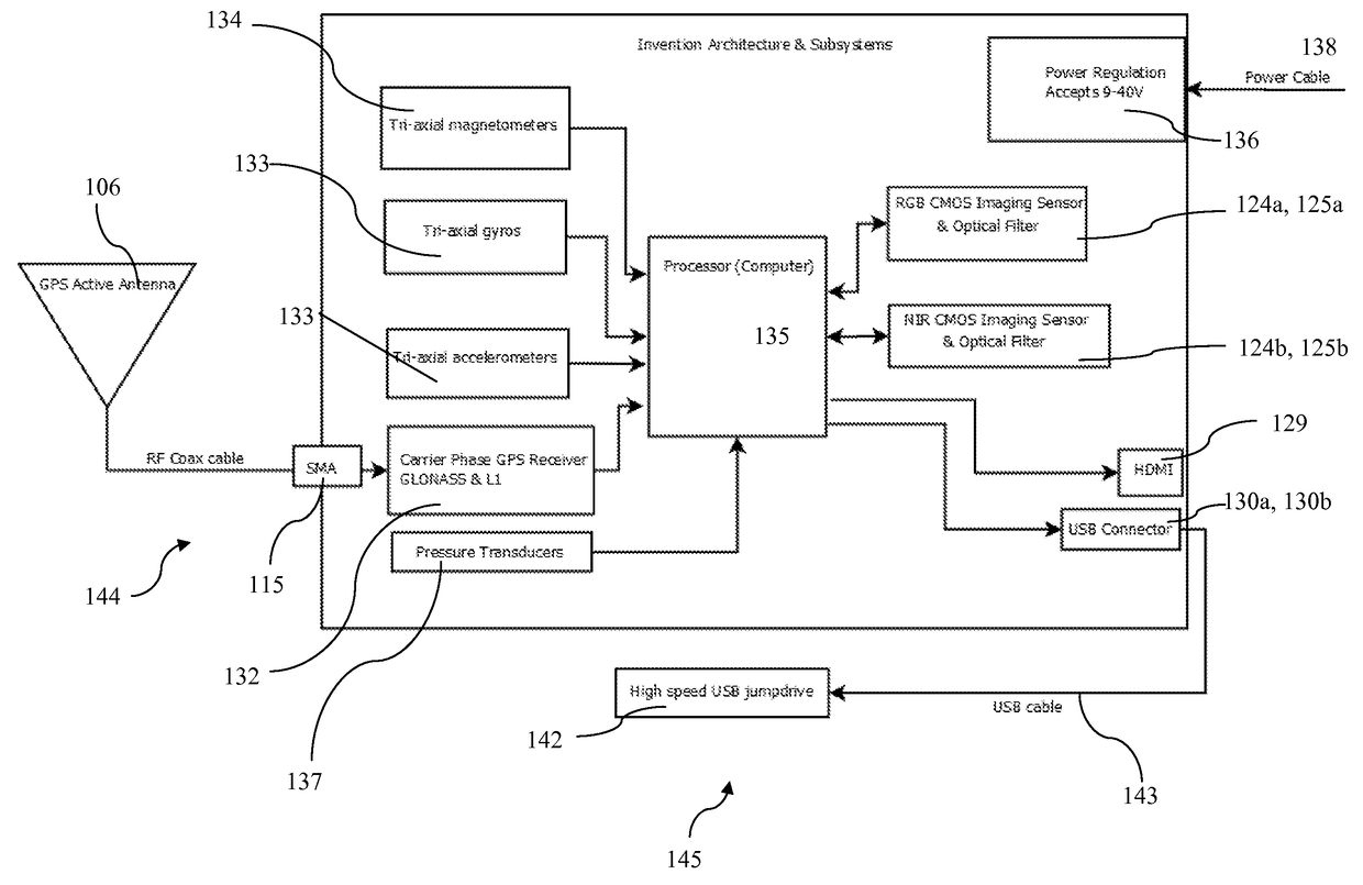
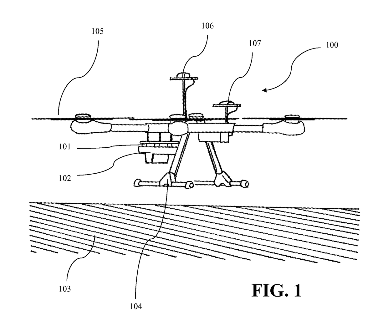
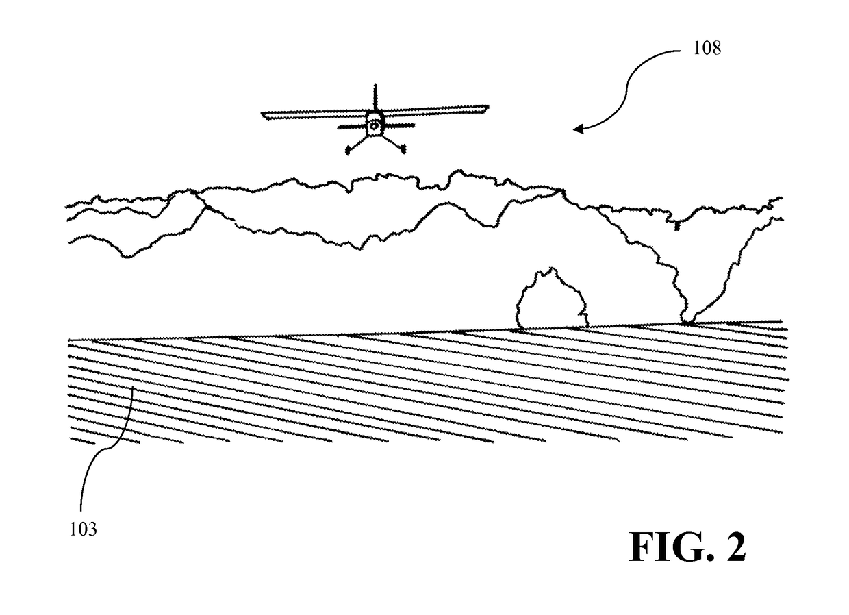
[0020]As depicted in FIG. 1, 100 is a multi-rotor platform hovering over an irrigated potato field 103, but field could contain any crop type or other foliage, including, for example, corn, soybean, wheat or any type of fruit tree, vine, nut, vegetable or tropical fruit. Multi-rotor platform 100 can be any airborne vehicle capable of carrying a payload and is mounted with vibration isolators 101 and enclosed in a mechanical enclosure 102 in an embodiment. Multi-rotor Unmanned Aerial Vehicles (UAVs) are ideal platforms for remote sensing applications due to their ability to withstand high wind environments as well as the ease of use to entry level UAV operators for take-off and landing events. Additionally, multi-rotors can be used when hovering or low-speed flight is desirable for specific high resolution applications. The multi-rotor depicted in FIG. 1. includes high efficiency propellers 105, landing gear 104, and the multi-rotor aerial vehicle mission critical GPS system 107. The...


PUM

PropertyMeasurementUnit
NIRaaaaaaaaaa
surface reflectanceaaaaaaaaaa
GPU accelerationaaaaaaaaaa

Abstract

A self-contained UAV sensor payload and on-board or off-board hardware and software for precision agriculture. The invention combines multiple cameras and navigation sensors to create a system for automatically collecting, geo-referencing, and stitching red, green, blue, and near infrared imagery and derived vegetation indices. The invention is able to produce all of these quantities in a single flight. The tight integration with integrated navigation sensors eliminates the need for integration with external sensors or avionics hardware and enables innovative solutions to image processing and analysis which greatly improve accuracy, processing speed, and reliability over alternative approaches.

Description

TECHNICAL FIELD[0001]Embodiments relate to arrangements of cameras and other sensors aboard an unmanned aerial vehicle (UAV) for use in agricultural settings.BACKGROUND[0002]Agricultural crops are often grown on farms which are too large for an individual to continuously monitor. As such, methods and systems for monitoring crops have been developed to reduce the chances of crop damage to some portion of a field due to, e.g., too little or too much water or fertilizer. Furthermore, it is important to discover damaging insects, fungi, or other blight as soon as possible, to prevent their spread to the rest of the field.[0003]In many cases, crop damage affects the reflectance of leaves. As described in Gregory A. Carter, Responses of Leaf Spectral Reflectance to Plant Stress, 80(3) American Journal of Botany 239-243 (1993), not only does the net reflectance change, but the spectrum of reflectance also changes. In particular, based on spectral reflectance regression analysis, and vegeta...

Claims


Application Information

Patent Timeline
Patent Type & Authority Patents(United States)
IPC IPC(8): G06K9/00G06T7/00G01N33/00H04N7/18G06T11/60H04N5/232H01L27/146
CPCG01N33/0098G06T7/0004H04N7/185G06T7/0024G06T11/60H04N5/23245H01L27/14645H01L27/14649G06T2207/30188G06T7/30G06T2207/10024Y02A40/10H04N23/951H04N23/11
Inventor POLING, BRYAN T.SALANT, KIMBERLY A.POLING, THEODORE C.LAUNER, CHRISTOPHER A.
Owner SENTEK SYST LLC
Why Eureka
Try Eureka