Navigation system for interested site and operation method therefor

Inactive Publication Date: 2010-03-17
江苏华科导航科技有限公司
View PDF10 Cites 0 Cited by
  • Summary
  • Abstract
  • Description
  • Claims
  • Application Information

AI Technical Summary

Problems solved by technology

[0005] Chinese patent application No. 200410091255.X discloses an auxiliary method for car satellite navigation destination setting, using the electronic map data in the webpage of the website to click and build a destination file, and the destination file data can be further passed Obtained by means of e-mail delivery, or uploaded to the storage unit of the navigation host by wireless transmission or via a memory card, thereby providing and assisting the navigation host to execute route planning, so as to solve the problem of insufficient or inapplicable traditional route information
[0006] The disadvantage of the above-mentioned prior art is that: POI files are pre-stored in the network map database, and only the network map database administrator has the authority to update and supplement the POI information
Therefore, the location of interest information in the network map database in the prior art cannot fully meet the actual needs of users.

Method used


Image

  • Navigation system for interested site and operation method therefor
  • Navigation system for interested site and operation method therefor
  • Navigation system for interested site and operation method therefor

Examples


Embodiment Construction

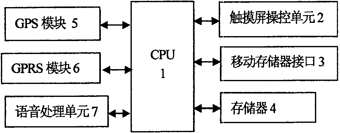
[0025] See figure 1 , the car navigator in the point of interest navigation system of the present embodiment includes: CPU1, touch screen control unit 2, mobile memory interface 3, memory 4, GPS module 5, GPRS module 6 and voice processing unit 7. The touch screen manipulation unit 2 includes key input and touch screen input circuits; the voice processing unit 7 can be used for voice recognition input. Through the touch screen control unit 2, the user inputs an operation command to the CPU 1, such as saving the vehicle's current location information to form a location of interest information file, or searching for a location of interest in a local navigator and setting it as a navigation destination.

[0026] The touch screen control unit 2 is used for displaying map images, displaying simulated routes determined through navigation route calculation, and receiving key commands and touch commands at the same time.

[0027] The memory 4 is used to store the digital map and the ...


PUM


Abstract

The present invention relates to a navigation system of the interesting places including: a navigator on a vehicle including a GPRS module for performing data communication with the internet; a network database for providing the information of the interesting places on the digital map and said information can be loaded by the navigator on a vehicle and is stored in the POI folder in the memory ofthe navigator on a vehicle; when an interesting place in the POI folder in the memory of the navigator is selected through a touch screen control unit to be a destination, the navigator on a vehicle turns into a route guiding state; in the navigator on a vehicle, the interesting place information in the memory is edited through the touch screen control unit and the interesting place information having been edited is transmitted to said network database through the GPRS module. The navigation system of the interesting places is suitable for updating POI files in time and can satisfy the individual need of different users.

Description

technical field [0001] The invention relates to a vehicle-mounted navigation system, in particular to a destination input system and a working method in path calculation in the navigation operation process. Background technique [0002] Vehicle-mounted navigators are widely used in car configurations. Its main function is to provide users with navigation services. Users only need to input a destination in the navigator, and the system can automatically complete the calculation of the navigation route, and use the display screen and voice Guide users along preset routes in real time. [0003] There are map data stored in the storage device of the car navigator, and these data are displayed on the touch screen to form a map image. The above map data also includes address information of some places of interest, which are often frequently used or more important addresses in a certain area, such as Banks, major shopping malls, major business buildings, hotels, government agencie...

Claims


Application Information

Patent Timeline
Patent Type & Authority Patents(China)
IPC IPC(8): G01C21/36G01C21/26G01S5/02
Inventor 秦春达李晓华
Owner 江苏华科导航科技有限公司
Why Eureka
Try Eureka