Method and apparatus associating GPS position with three-dimensional laser scanner measurement

A technology of GPS positioning and three-dimensional laser, which is applied in the field of contacting GPS positioning and three-dimensional laser scanner measurement, and can solve problems such as deviation of measurement results

Inactive Publication Date: 2008-11-12
CHINA UNIV OF MINING & TECH
View PDF0 Cites 25 Cited by
  • Summary
  • Abstract
  • Description
  • Claims
  • Application Information

AI Technical Summary

Problems solved by technology

However, the position information obtained by the 3D laser scanner is a kind of relative position information in the machine coordinate system (a relative coordinate system), so it is necessary to convert the relative information obtained by the 3D laser scanner into a unified coordinate system ; In the case of unstable ground environment, the control point will change with ...

Method used


Image

  • Method and apparatus associating GPS position with three-dimensional laser scanner measurement

Examples


Embodiment Construction

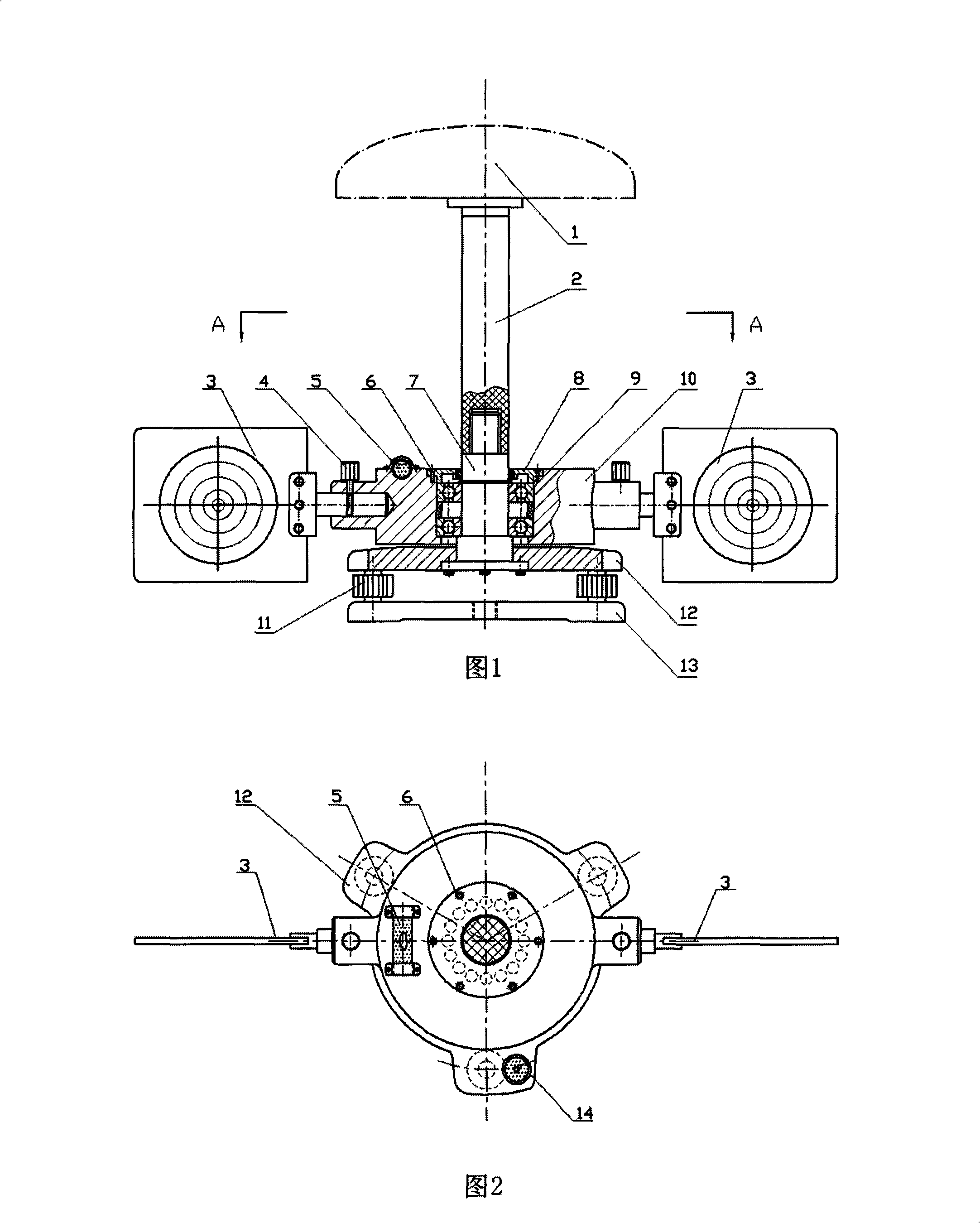
[0017] An embodiment of the present invention will be further described below in conjunction with accompanying drawing:

[0018] The present invention contacts the method for GPS positioning and three-dimensional laser scanner measurement: the device that contacts GPS positioning and three-dimensional laser scanner measurement is arranged on the tripod (the abbreviation of GPS-Global Positioning System, meaning Global Positioning System) with bolt, simultaneously Set up three or more positions and level them; by rotating the turntable 10 of the target device, the two targets 3 of the target device are aligned with the scanning direction of the three-dimensional laser scanner; first align the two targets with the three-dimensional laser scanner. The bull's-eye of each target 3 is scanned once, and then the target device is rotated 180°, and the bull's-eye of the two targets 3 is scanned again, and the mean value of the two scans of the target 3 is taken to eliminate the horizont...


PUM


Abstract

The invention relates to a method of associated GPS positioning and 3D laser scanner measurement and apparatus thereof, wherein WGS-84 coordinates acquired through static positioning by a GPS receiver are introduced into 3D laser scanner measurement for being used in controlling coordinate conversion. The method realizes monitoring of 3D absolute deformation amount of a 3D laser scanner through a resolved equation of transformation, and associates GPS positioning with 3D laser scanner measurement through cooperation with the apparatus mainly composed of a pedestal, a beacon, and a connecting rod for holding the GPS receiver. The method is effectively applicable to deformation monitoring of multi-story buildings and bridges, wherein the geometrical center of the apparatus can be used as the control point by simply leveling the instrument without setting of special control points. The apparatus, being reasonably compact in structure, simply operable and portable, is widely applicable to engineering survey, academic research, educational training and practice, as well as solution of practical engineering problems in industrial and mining enterprises and civil construction.

Description

technical field [0001] The invention relates to a method and device for linking GPS positioning and three-dimensional laser scanner measurement, and is especially suitable for determining the three-dimensional absolute deformation measurement of a measured object. Background technique [0002] At present, in the deformation monitoring of high-rise buildings, bridges, etc., 3D laser scanners are often used to measure and obtain the 3D deformation information of the target. However, the position information obtained by the 3D laser scanner is a kind of relative position information in the machine coordinate system (a relative coordinate system), so it is necessary to convert the relative information obtained by the 3D laser scanner into a unified coordinate system ; In the case of unstable ground environment, the control point will change with the change of the ground. For example, in the deformation monitoring of the mining area, the control point will be displaced due to und...

Claims


Application Information

Patent Timeline
IPC IPC(8): G01B11/16G01S5/02G01S1/02G01S19/42
Inventor 王坚闫文林张建勋孙久运高井祥
Owner CHINA UNIV OF MINING & TECH
Why Eureka
Try Eureka