Method and system for vehicle real time navigation

A navigation method and vehicle technology, which are applied to the traffic control system, signal transmission system, traffic control system and other directions of road vehicles, and can solve the problem that the vehicle navigation system cannot evaluate the real-time condition of the road section.

Inactive Publication Date: 2009-01-21
KONKA GROUP
View PDF0 Cites 51 Cited by
  • Summary
  • Abstract
  • Description
  • Claims
  • Application Information

AI Technical Summary

Problems solved by technology

[0003] In order to solve the technical problem that the vehicle navigation system in the prior art cannot evaluate the real-time conditions of the road section, resulting in the selected route not being the actual optimal route, the presen

Method used


Image

  • Method and system for vehicle real time navigation
  • Method and system for vehicle real time navigation
  • Method and system for vehicle real time navigation

Examples


Embodiment Construction

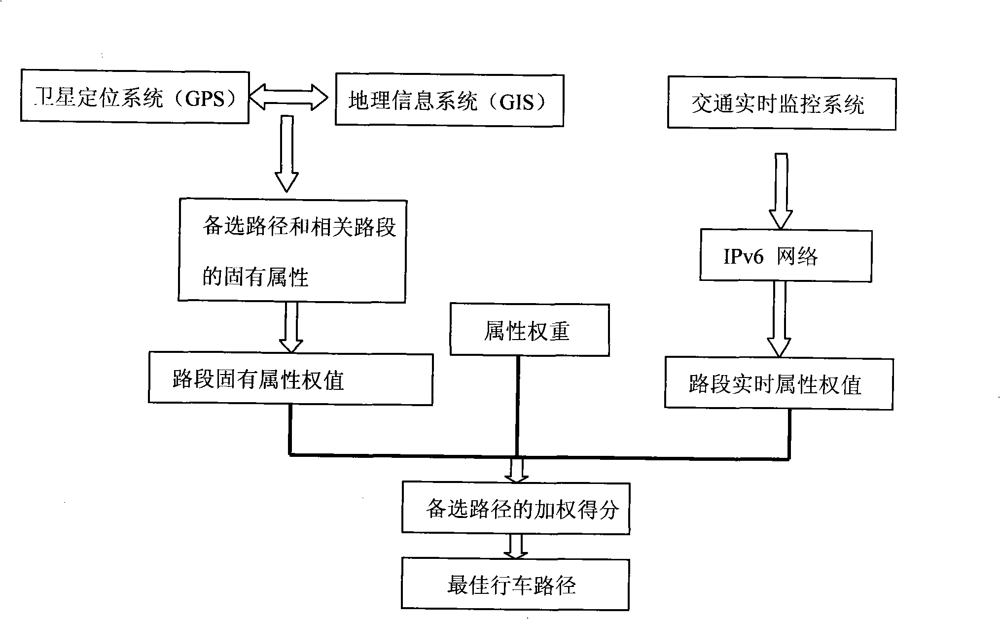
[0017] Such as figure 1 as shown, figure 1 It is a system data flow chart of the vehicle real-time navigation system of the present invention.

[0018] In the vehicle real-time navigation system of the present invention, at first, according to the user's origin and destination, the first and second distances between the origin and the destination are given by the satellite positioning system (GPS) and the geographic information system (GIS). 2. The third and even the Kth candidate paths, the number of the candidate paths can be determined according to experience values. The geographic information system (GIS) further gives the weight value of the inherent attributes of each road segment related to the alternative path. Subsequently, for each relevant road section, the system's real-time communication system (not shown) sends a request to the traffic real-time monitoring system in order to obtain the weight value of the real-time attribute of the relevant road section. Then,...


PUM


Abstract

The invention relates to a vehicle real-time navigation method and a system, wherein the navigation method comprises obtaining a plurality of alternative paths according to the initial addresses and the destinations of users, obtaining the weight value of the inherent attribute of relative roads, gaining the weight value of the real-time attribute of relative roads according to the real-time monitoring information, and gaining the weighing score of alternative paths according to the weight values of the inherent attribute and the real-time attribute and the relative weighting, and selecting the running path according to the weighing score. The invention further introduces the concepts of real-time attribute, weighting and weight value in a current vehicle navigation system based on a globe positioning system and a geographic information system through the method and the system. And the real-time passing condition and the weighing score for the running path can be obtained through utilizing the combination of real-time attribute gained from the real-time monitoring and the inherent attribute.

Description

【Technical field】 [0001] The invention relates to a vehicle real-time navigation method and system, in particular to a vehicle real-time navigation method and system based on a satellite positioning system and a geographic information system. 【Background technique】 [0002] In existing vehicle navigation systems, the selection of driving routes is often based on the principle of the shortest distance. The satellite positioning system (GPS) and the geographic information system (GIS) give multiple alternative routes and the lengths of the relevant road sections, and the processing system sums the lengths of the relevant road sections, and takes the path with the shortest distance as the optimal driving route. However, it is well known that the travel time to the destination is not only determined by the distance, but also affected by many factors, such as road grade, road surface quality, traffic control, traffic flow, average vehicle speed and so on. In particular, real-tim...

Claims


Application Information

Patent Timeline
IPC IPC(8): G01C21/26G01C21/34G01S1/02G01S5/02G08G1/0962G08G1/0968G08C17/02G08C19/00G01S19/39
Inventor 胡佳文袁洪张木森
Owner KONKA GROUP
Why Eureka
Try Eureka