Geomagnetic auxiliary navigation algorithm based on matching degree

An auxiliary navigation and matching technology, applied in ground navigation, navigation calculation tools, etc., can solve problems such as mismatching and poor real-time performance

Inactive Publication Date: 2009-01-28
BEIHANG UNIV
View PDF0 Cites 36 Cited by
  • Summary
  • Abstract
  • Description
  • Claims
  • Application Information

AI Technical Summary

Problems solved by technology

The traditional matching method only uses the total intensity information in the geomagnetic elements. After accumulating a sequence, use the contour features on the geomagnetic map to use the MAD or MSD criteria for matching and positioning. Since only a single elem...

Method used


Image

  • Geomagnetic auxiliary navigation algorithm based on matching degree
  • Geomagnetic auxiliary navigation algorithm based on matching degree
  • Geomagnetic auxiliary navigation algorithm based on matching degree

Examples


Embodiment Construction

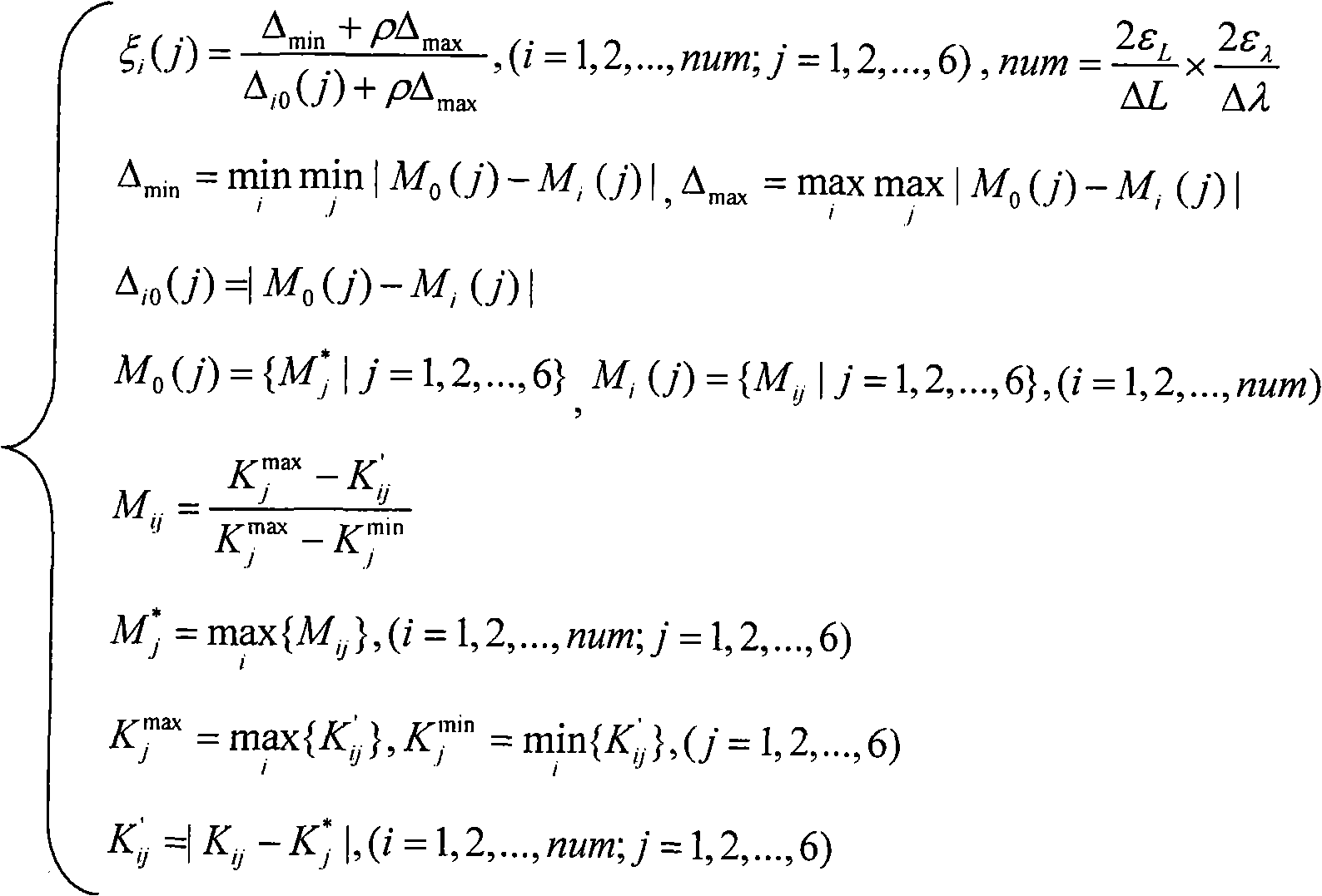
[0031] The longitude allowable error index ε of the navigation requirement of the selected instance L is 0.001 degrees, and the latitude allowable error index ε λ The grid size ΔL in the longitude direction of the geomagnetic map selected in the example is 0.0002 degrees, and the grid size Δλ in the latitude direction is 0.0002 degrees.

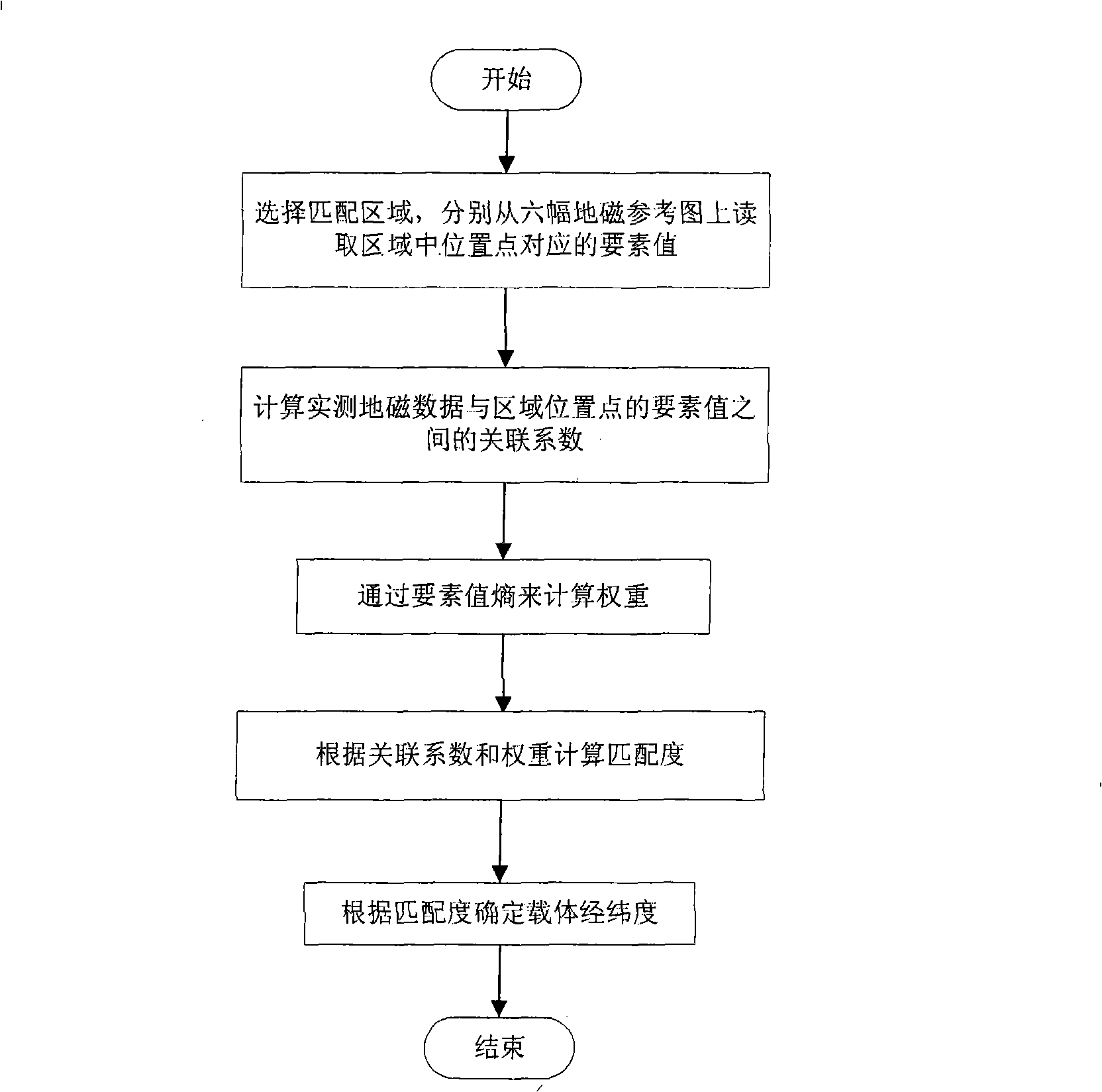
[0032] like figure 1 Shown, concrete method of the present invention is as follows:

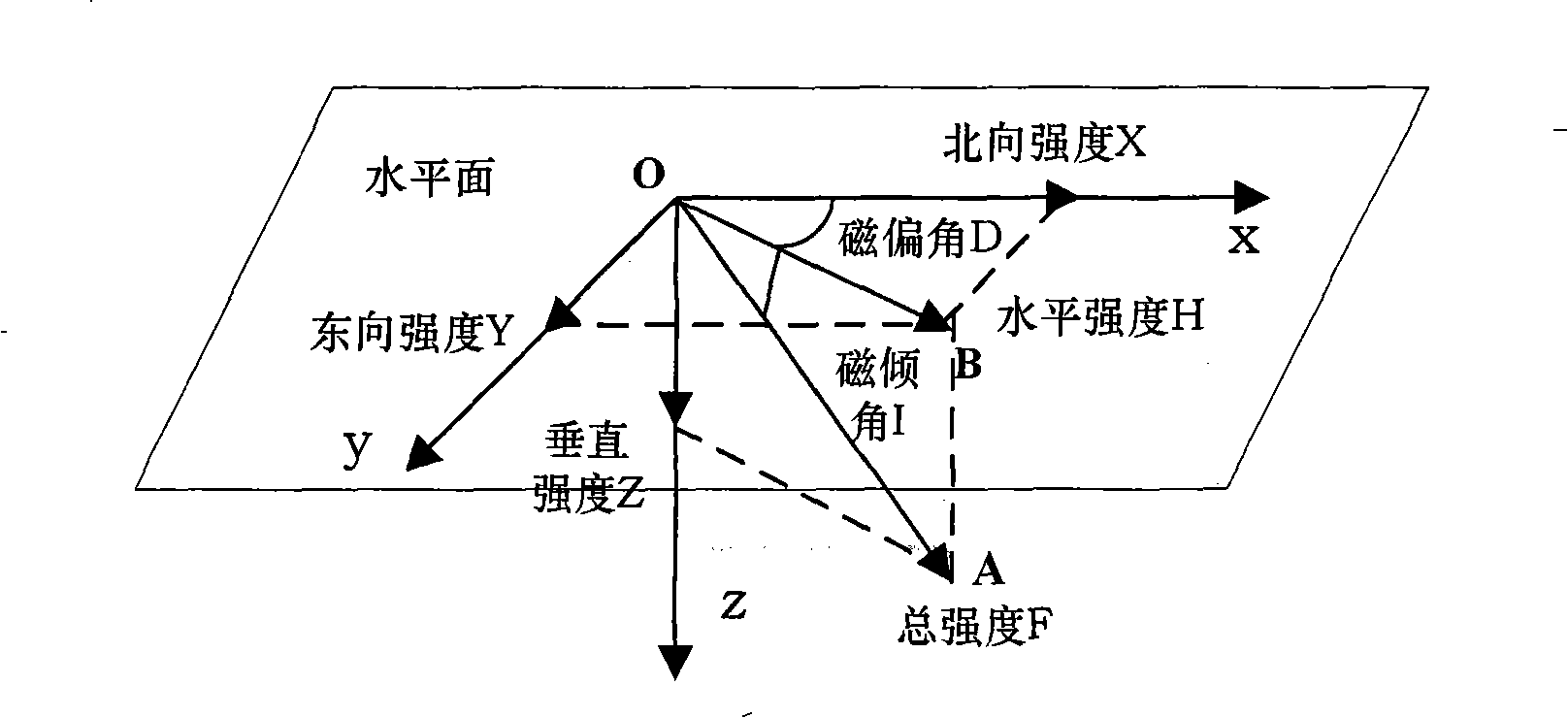
[0033] (1) Select the matching area, and read the element values ​​corresponding to the location points in the area from the six geomagnetic reference maps of total intensity, magnetic inclination, magnetic declination, northward intensity, eastward intensity, and vertical intensity.

[0034] Real-time strapdown calculation of the carrier's latitude and longitude according to the measurement data of the inertial measurement unit The matching area is calculated by inertial navigation As the center, a rectangular area with a side length of 0.002 deg...


PUM


Abstract

The invention discloses a geomagnetism-aided navigation method based on match degree, relating to a geomagnetic matching algorithm. The method of the invention calculates the match degree according to a gray correlation coefficient and the weight of a geomagnetic element and measures the similarity degree between the geomagnetic element value corresponding to a position point in a matching region and the geomagnetic element value actually measured by a magnetic sensor, thereby judging a matching point in the matching region and finally carrying out the matching positioning. Compared with the traditional contour matching algorithm, the method of the invention fully utilizes the information of a geomagnetic field vector for carrying out the vector positioning, eliminates the error-matching phenomenon which possibly occurs in the traditional matching algorithm, realizes precise positioning and has good real-time performance.

Description

technical field [0001] The invention relates to a matching degree-based geomagnetism-assisted navigation method, which is applicable to the technical field of aviation navigation, and can be applied to navigation and positioning of aircrafts and underwater submersibles. Background technique [0002] With the development of the national economy, navigation and positioning technology has increasingly become an indispensable technical means in the fields of traffic control, disaster relief, logistics management, land survey, survey, etc.; precise strikes in the military field rely on high-precision, high-reliability navigation means , and put forward requirements for autonomous concealment. High-precision positioning technology has become a key technology that countries are paying more and more attention to and vigorously developing. [0003] At present, in the field of aviation navigation technology, there are abundant navigation methods for combination, mainly including iner...

Claims


Application Information

Patent Timeline
IPC IPC(8): G01C21/08G01C21/20
Inventor 房建成冯浩楠黄学功韩晓英
Owner BEIHANG UNIV
Why Eureka
Try Eureka