Height difference measuring method and digital device

A technology of height difference and measuring instrument, applied in the field of measurement, can solve the problems of expensive instrument, inconvenient to carry, time-consuming, etc., and achieve the effects of improving measurement efficiency, digitizing information, and low development cost

Inactive Publication Date: 2009-06-17
CENTRAL SOUTH UNIVERSITY OF FORESTRY AND TECHNOLOGY
View PDF0 Cites 14 Cited by
  • Summary
  • Abstract
  • Description
  • Claims
  • Application Information

AI Technical Summary

Problems solved by technology

Advanced total station, automatic leveling level, electronic level and precision level are seldom used in height difference measurement in current forestry practice. A little branch, leaf and shrub cover in front of the observation target can make it impossible for advanced instruments such as total stations to measure. It will be laborious, labor-intensive, and time-consuming to remove the cover. In addition, this type of instrument is expensive and expensive. Many reasons, such as inconvenient to carry, make it difficult for advanced instruments to play their due role in forestry engineering survey and design, so they can be popularized and promoted
At present, the height difference measurement in forestry is still done with an ordinary level and a leveling rod. Similarly, if there are miscellaneous shrubs under the forest, it is very difficult to use the horizontal line of sight of the level to read the front and rear readings of the leveling rod. Most of the time It takes a lot of effort to clean up miscellaneous shrubs, and because the most important and basic condition for the operation of the level is the level of sight, the inspection and calibration of the level, the elimination of parallax, accurate leveling, and accurate readings require careful and serious work. Generally, skilled professional surveyors are required to complete it. However, professional surveyors will inevitably travel in many processes such as naked eye readings, recorder counting, and tedious internal work. In addition, the measurement function of the level is single. In actual measurement, Not only to measure the elevation between two points, but also to measure the horizontal distance and slope between two points, and the horizontal distance measurement is still using a tape measure. If the terrain is very steep, the tape measure can only measure the slope distance, and then measure the slope and then correct the slope , which is rather cumbersome
Therefore, due to the singleness of the measurement function of the level instrument, the rigor of the measurement process, and the limitations of the measurement conditions, it is sometimes difficult to guarantee the accuracy in forestry engineering surveys and the overall measurement work is usually inefficient.

Method used


Image

  • Height difference measuring method and digital device
  • Height difference measuring method and digital device
  • Height difference measuring method and digital device

Examples


Embodiment 1

[0054] Embodiment 1: comprise the following steps in turn:

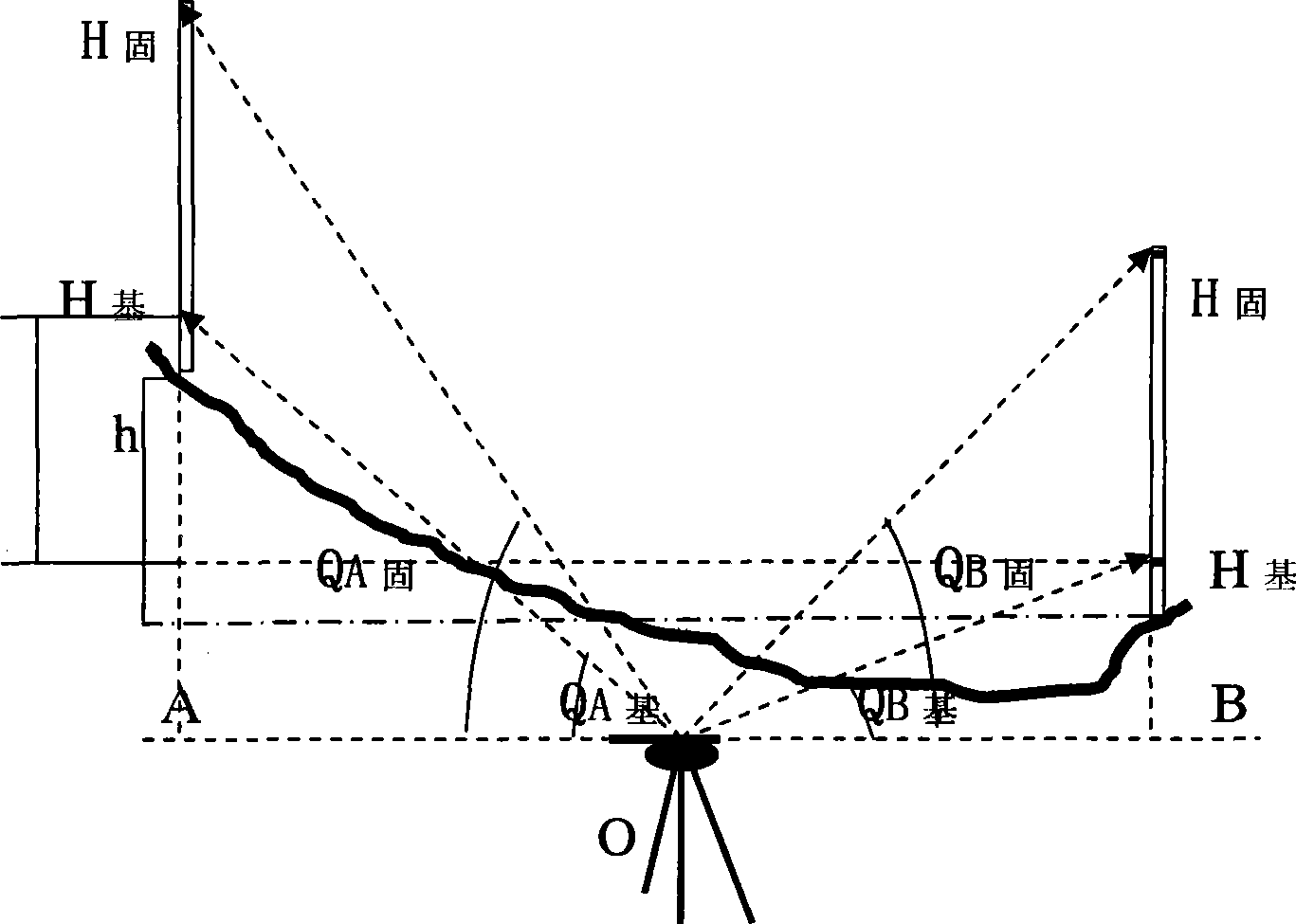
[0055] (1) The instrument is set between A and B, and an observation point 0 is arbitrarily selected.

[0056] (2) The same 3-meter ruler is erected on terrain A and terrain B respectively (or the ruler is moved to point B after the measurement at point A is completed), there are two observation marks on the ruler, and the mark at 0.7 meters below the ruler point as base high H 0.7 , the mark point at the upper 3 meters of the ruler is the fixed height H 3

[0057] (3) At 0 point, first observe the two marker points of the A terrain scale, and measure the basic high point H 0.7 , the fixed high point H 3 The line-of-sight inclination θ A0.7 , θ A3 .

[0058] (4) Then observe the two marker points of the B terrain scale at 0, and measure the base high point H 0.7 , the fixed high point H 3 The line-of-sight inclination θ B0.7 , θ B3 .

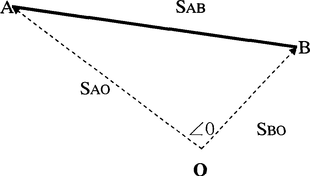
[0059] (5), let the horizontal distance between A and 0 be S AO , the...

Embodiment 2

[0070] Embodiment 2: comprise the following steps in turn:

[0071] (1) The instrument is set between A and B, and an observation point 0 is arbitrarily selected.

[0072] (2) Erect the same 2-meter ruler on terrain A and terrain B respectively (or move the ruler to point B after measuring at point A). There are two observation marks on the ruler. The lower part of the ruler is at a height of 0.4 meters. Mark point as base high H 0.4 , the upper 2m mark point of the ruler is the fixed height H 2

[0073] (3) At 0 point, first observe the two marker points of the A terrain scale, and measure the basic high point H 0.4 , the fixed high point H 2 The line-of-sight inclination θ A0.4 , θ A2 .

[0074] (4) Then observe the two marker points of the B terrain scale at 0, and measure the base high point H 0.4 , the fixed high point H 2 The line-of-sight inclination θ B0.4 , θ B2 .

[0075] (5), let the horizontal distance between A and 0 be S AO , the horizontal distance ...

Embodiment 3

[0086] Embodiment 3: comprise the following steps in turn:

[0087] (1) The instrument is set between A and B, and an observation point 0 is arbitrarily selected.

[0088] (2) Erect the same 3-meter ruler on terrain A and terrain B respectively (or move the ruler to point B after measuring at point A). There are two observation marks on the ruler. The lower part of the ruler is 0.4 meters high. Mark point as base high H 0.4 , the 3-meter mark point on the upper part of the ruler is the fixed height H 3

[0089] (3) At 0 point, first observe the two marker points of the A terrain scale, and measure the basic high point H 0.4 , the fixed high point H 3 The line-of-sight inclination θ A0.4 , θ A3 .

[0090] (4) Then observe the two marker points of the B terrain scale at 0, and measure the base high point H 0.4 , the fixed high point H 3 The line-of-sight inclination θ B0.4 , θ B3 .

[0091] (5), let the horizontal distance between A and 0 be S AO , the horizontal di...


PUM


Abstract

The invention discloses a method for measuring altitude difference and a digitalizer. The method is as follows that an instrument measures four inclination angle values and a point-point horizontal included angle; the point-point topography altitude difference data can be obtained according to the triangle principle; and then the horizontal distance and the gradient data of the point-point topography can be obtained by using the cosine theorem and gradient mathematic expression. The digitalizer comprises an optical laying component, a horizontal rotating disc, a display screen, an electric-control function unit, an external control unit and an A-frame component. The optical laying component comprises a telescope and a tilt angle sensor arranged on the telescope. The horizontal rotating disc is arranged on the A-frame component, is provided with the display screen and the external control component, and is internally provided with an angular displacement sensor arranged on the rotation axis center of the horizontal rotating disc and an electric-control function unit. The method and the device can fast accurately measure the point-point altitude difference, the horizontal distance and gradient in time.

Description

technical field [0001] The invention belongs to the technical field of measurement, and in particular relates to a method and a digital device for measuring the height difference, which can measure the height difference between two points and simultaneously measure the horizontal distance and the slope between the two points in forestry surveying. Background technique [0002] For forestry survey, the height difference between two points is often measured first, such as forest road survey, woodland topographic survey and ground point elevation survey. The height difference measurement rarely uses advanced total station, automatic leveling level, electronic level and precision level in the current forestry application. A little bit of branches, leaves and bushes in front of the observation target will prevent advanced instruments such as total stations from measuring. It will be laborious, labor-intensive, and time-consuming to remove the obstructions. In addition, such instr...

Claims


Application Information

Patent Timeline
Patent Type & Authority Applications(China)
IPC IPC(8): G01C5/00G01C1/00G01C3/04
Inventor 曾思齐佘济云赵坤鄢前飞汤腾方
Owner CENTRAL SOUTH UNIVERSITY OF FORESTRY AND TECHNOLOGY
Why Eureka
Try Eureka