Vehicle-mounted SINS/GPS combined navigation system performance reinforcement method

A technology of integrated navigation system and performance, applied in the field of performance enhancement of vehicle-mounted SINS/GPS integrated navigation system, can solve the problems of low system accuracy and poor reliability, and achieve the effect of improving accuracy and reliability and improving positioning accuracy

Inactive Publication Date: 2009-07-08
HARBIN INST OF TECH
View PDF0 Cites 73 Cited by
  • Summary
  • Abstract
  • Description
  • Claims
  • Application Information

AI Technical Summary

Problems solved by technology

[0007] The present invention proposes a method for enhancing the performance of a vehicle-mounted SINS / GPS integrated navigation system in order to solve the problems of low system accuracy and poor reliability when the GPS temporarily fails in the existing vehicle-mounted SINS / GPS integrated navigation system

Method used


Image

  • Vehicle-mounted SINS/GPS combined navigation system performance reinforcement method
  • Vehicle-mounted SINS/GPS combined navigation system performance reinforcement method
  • Vehicle-mounted SINS/GPS combined navigation system performance reinforcement method

Examples


specific Embodiment approach 1

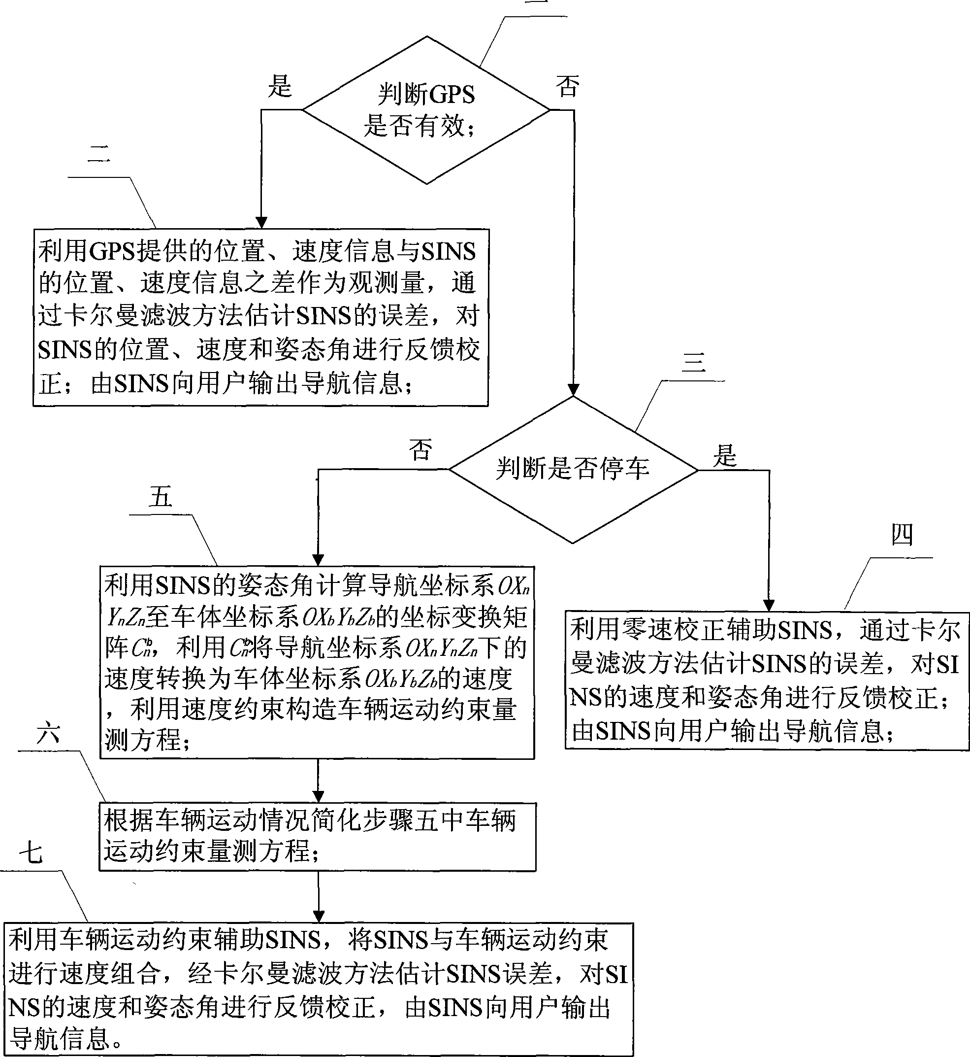
[0018] Specific implementation mode one: combine figure 1 Describe this embodiment, the steps of this embodiment are as follows:

[0019] Step 1: Determine whether the GPS is valid; if yes, go to step 2; if not, go to step 3;

[0020] Step 2: Use the difference between the position and velocity information provided by GPS and the position and velocity information of SINS as the observation quantity, estimate the error of SINS through the Kalman filter method, and perform feedback correction on the position, velocity and attitude angle of SINS, and send the information from SINS to The user outputs navigation information;

[0021] Step 3: Determine whether to stop; if yes, go to step 4; if not, go to step 5;

[0022] Step 4: Use zero-speed correction to assist SINS, estimate the error of SINS by Kalman filter method, perform feedback correction on the speed and attitude angle of SINS, and output navigation information to the user from SINS;

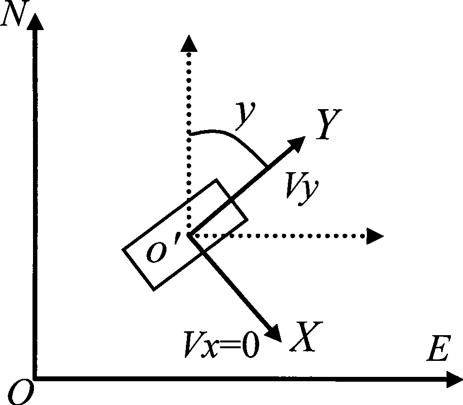
[0023] Step 5: Use the attitude ...

specific Embodiment approach 2

[0026] Specific embodiment two: the difference between this embodiment and specific embodiment one is that step two is the navigation process when GPS is valid;

[0027] First, establish the mathematical model of SINS / GPS integrated navigation, including system equations and measurement equations.

[0028] The system equation is the SINS error equation ignoring the height channel, as shown in formula (1):

[0029] X . 1 ( t ) = F 1 ( t ) X 1 ( t ) + w 1 ( t ) - - - ( 1 )

[0030] x 1 is the system equation state vector, ...

specific Embodiment approach 3

[0061] Specific embodiment three: the difference between this embodiment and specific embodiment two is that step four is the navigation process when the GPS is invalid and in the parking state;

[0062] Firstly, the mathematical model of zero-speed correction assisted SINS is established, in which the system equation is the same as (1), and the measurement equation is:

[0063] Z 2 =H 2 x 1 +v 2 (10)

[0064] v 2 is the observation noise, the observation matrix H 2 for

[0065] h 2 =[0 2×3 I 2×2 0 2×7 ] 2×12 (11)

[0066] Observation Z 2 for

[0067] Z 2 =[V ESINS -V E V NSINS -V N ] T =[V ESINS V NSINS ] T (12)

[0068] Finally, the error of SINS is estimated by Kalman filter method, and the velocity and attitude angle of SINS are corrected by feedback. Other steps are the same as in the second embodiment.


PUM


Abstract

The invention discloses a method for enhancing the performance of a vehicle-mounted SINS / GPS combined navigation system. The invention relates to the technical field of navigation and solves the problems of the prior vehicle-mounted SINS / GPS combined navigation system of low precision and low reliability of the system due to the temporary failure of the GPS. The method comprises the following steps: firstly, judging whether or not the GPS is effective; if the GPS is effective, evaluating and correcting an SINS error by a Kalman filtering method and by using the difference between position and velocity information provided by the GPS and the position and velocity information of the SINS as an observed quantity; if the GPS is noneffective, judging whether or not to stop; if to stop, correcting the SINS error by using a zero velocity update auxiliary SINS; if not to stop, calculating coordinate transformation matrix Cn from a navigation coordinate system to a vehicle body coordinate system by using the attitude angle of the SINS, converting the velocity under the navigation coordinate system into a velocity under the vehicle body coordinate system by using the Cn and creating a vehicle motion constraint measurement equation by using velocity constraint; simplifying the equation according to vehicle motion; and carrying out the velocity composition of the SINS and the vehicle motion constraint and correction by using a vehicle motion constraint auxiliary SINS. The method is used for improving the precision and reliability of the vehicle-mounted SINS / GPS combined navigation system.

Description

technical field [0001] The invention relates to the technical field of navigation, in particular to a method for enhancing the performance of a vehicle-mounted SINS / GPS integrated navigation system. Background technique [0002] Strapdown Inertial Navigation System (SINS, Strapdown Inertial Navigation System), referred to as inertial navigation system, is a completely autonomous navigation system, which can continuously provide various navigation parameter information such as the position, speed, orientation and attitude of the carrier, and can track the carrier Fast maneuvering movement, good stability in a short time. However, the error of inertial navigation accumulates over time, and it cannot work alone for a long time, and must be constantly calibrated. [0003] Global Positioning System (GPS, Global Positioning System) is currently the most widely used satellite navigation and positioning system. It has high positioning and speed measurement accuracy, good long-term ...

Claims


Application Information

Patent Timeline
Patent Type & Authority Applications(China)
IPC IPC(8): G01C21/28G01S5/02
Inventor 崔平远徐敏强崔祜涛徐田来
Owner HARBIN INST OF TECH
Why Eureka
Try Eureka