Method for estimating temperature of near-surface air from MODIS data

A technology of air temperature and surface temperature, applied in ICT adaptation, climate sustainability, re-radiation of electromagnetic waves, etc., can solve the problems of interpolation accuracy and timeliness of meteorological stations, and improve inversion accuracy and calculation time, providing estimation accuracy, and practical and simple effects of operation

Inactive Publication Date: 2010-01-27
INST OF AGRI RESOURCES & REGIONAL PLANNING CHINESE ACADEMY OF AGRI SCI +1
View PDF1 Cites 28 Cited by
  • Summary
  • Abstract
  • Description
  • Claims
  • Application Information

AI Technical Summary

Problems solved by technology

[0009] The purpose of the present invention is to provide a method for estimating the near-surface air temperature from remote sensing data MODIS, to overcome the practical difficulties that the existing near-surface air temperature is difficult to obtain using physical methods, and the shor

Method used


Image

  • Method for estimating temperature of near-surface air from MODIS data
  • Method for estimating temperature of near-surface air from MODIS data
  • Method for estimating temperature of near-surface air from MODIS data

Examples


Embodiment Construction

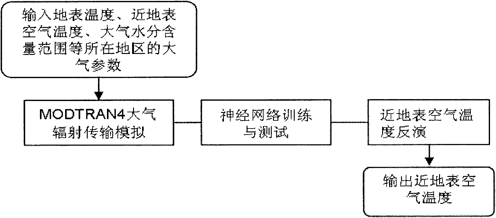
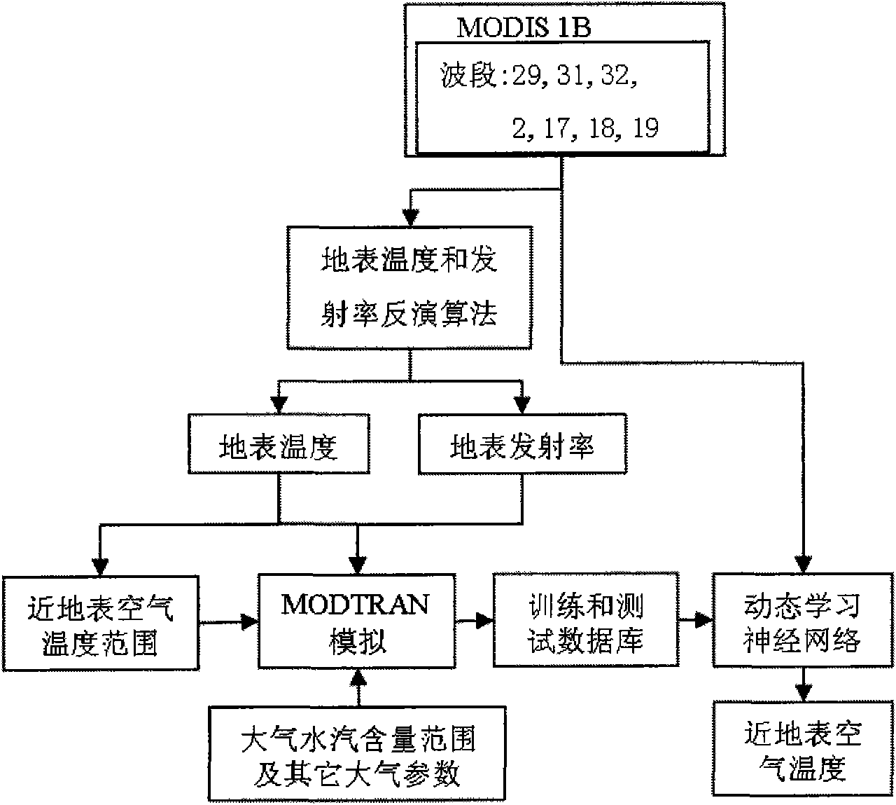
[0042] The inversion of land surface temperature and emissivity is based on the thermal radiation transfer equation, and the general expression is shown in formula (1) [Mao Kebiao, research on land surface temperature inversion method based on MODIS data, master's thesis, Nanjing University, 2004.5.] :

[0043] B i (T i )=ε i (θ)τ i (θ)B i (T s )+[1-τ i (θ′)][1-ε i (θ)τ i (θ) (Equation 1)

[0044] B i (T ia )+[1-τ i (θ)] B i (T ia )

[0045] where T s is the surface temperature, T i Indicates the brightness temperature of the star obtained by channel i at the height of the sensor, τ i (θ) represents the atmospheric transmittance of channel i in the observation direction θ, θ′ represents the direction of the downward brightness temperature radiation of the atmosphere, ε i (θ) represents the surface emissivity of channel i at the observation direction θ. B i (T i ) is the radiation intensity received by the sensor, B i (T s ) Radiation intensity at the sur...


PUM


Abstract

The invention relates to a method for estimating the temperature of near-surface air near from MODIS data, which can be used for remote sensing application departments, i.e. weather, environmental monitoring, land management, agricultural monitoring, disaster monitoring, and the like. The method comprises three steps: step1: utilizing the near-surface temperature and the emission rate of each pixel of a MODIS data product and the water vapour content value of atmosphere as priori knowledge and input parameters of atmosphere radiation transmission module simulation software MODTRAN4, carrying out forward direction simulation in different areas and seasons aiming at a 29th thermal infrared band, a 31st thermal infrared band and a 32nd thermal infrared band of each pixel of the obtained remote sensing data MODIS and establishing a training and testing database; step2: utilizing a neural network to repeatedly training and testing a training and testing dataset; step3: carrying out back calculation for practical image data of the MODIS to obtain the temperature distribution condition of the air near the earth's surface of an objective area of the earth's surface. The method can be usedfor weather prognosis, the environmental monitoring, the agricultural monitoring, the disaster monitoring, and the like.

Description

technical field [0001] The invention relates to a method for estimating the air temperature near the surface of the earth by using the ground thermal radiation information obtained by the MODIS sensor on the earth observation satellite, which breaks through the limitation of the traditional ground observation. It can be applied in remote sensing departments such as meteorology, agriculture, environmental monitoring and drought monitoring. Background technique [0002] Near-surface air temperature refers to the temperature about 2 meters above the surface, which is a very important parameter in climate change research [Sun, Y.J., Wang J.F., Zhang, R.H., Gillies, R.R., Xue Y.andBo Y.C., Air temperature retrieval from remote sensing data based on thermodynamics. Theoretical and Applied Climatology, 2005, 80: 37-48.]. Since the near-surface air temperature is affected by time and space, as well as the surface conditions, there is no method to estimate the spatial distribution o...

Claims


Application Information

Patent Timeline
IPC IPC(8): G01S17/95G01S17/88
CPCY02A90/10
Inventor 毛克彪王道龙张立新任天志李三妹高懋芳
Owner INST OF AGRI RESOURCES & REGIONAL PLANNING CHINESE ACADEMY OF AGRI SCI
Why Eureka
Try Eureka