Orthogonal Section Method for Digital Shoreline Evolution Analysis

A cross-section and shoreline technology, applied in the field of shoreline evolution analysis system, can solve the problem of work efficiency, computational accuracy that cannot be adapted to large-scale business applications, lack of targeted analysis tools, and unreliable non-straight shorelines. questions to achieve comparability, enhance intuition, and eliminate intensity and subjectivity

Inactive Publication Date: 2011-12-28
EAST CHINA NORMAL UNIV
View PDF0 Cites 1 Cited by
  • Summary
  • Abstract
  • Description
  • Claims
  • Application Information

AI Technical Summary

Problems solved by technology

The article "Research on the Prediction of Regional Evolution of the Yellow River Mouth" in "Acta Oceanographica" in Volume 14, Issue 3, 1992 introduced a method of central radial section, which is formed by making a straight line intersect with the coastline starting from the base point selected by the user. The disadvantage is that this method is only suitable for analyzing fan-shaped delta coasts with a relatively regular shape, and cannot be used for other coast types; the report "Digital Shoreline Analysis System (DSAS) version 4.0 -AnArcGIS extension for calculating shoreline change" ("Digital Shoreline Analysis System 4.0-An ArcGIS Extension for Calculating Shoreline Change") discloses a vertical section method, which is composed of equal distances perpendicular to the user-selected shoreline The shortcoming is that this method is only suitable for the analysis of simple straight shorelines, and cannot obtain reliable results for complex non-straight shorelines.
In particular, with the improvement of the spatial accuracy of the available data, the complexity of the digital coastline and the requirement for the accuracy of the analysis results are also increasing, which has become one of the main challenges faced by the traditional transect method
On the other hand, there is also a lack of targeted analysis tools in practical applications. The usual method is to implement a large number of manual operations step by step with the help of functions of other analysis software such as ArcGIS, MapInfo, Excel, etc. The work efficiency, calculation Accuracy cannot meet the requirements of current large-scale business applications
In addition, the coastal zone is a sensitive area of ​​social and economic development. The evolution of the coastal zone should not only be understood by professionals, but also needs to be known and paid attention to by the general public. Therefore, it is necessary to develop a way that the public can easily recognize to display the coastal zone. Evolving professional information, while a similar systematic approach is currently lacking

Method used


Image

  • Orthogonal Section Method for Digital Shoreline Evolution Analysis
  • Orthogonal Section Method for Digital Shoreline Evolution Analysis
  • Orthogonal Section Method for Digital Shoreline Evolution Analysis

Examples


Embodiment Construction

[0046] For the convenience of explaining the specific implementation, the present invention will be further described in detail below by taking the non-straight coastline of Dongtan, Chongming, Shanghai as an example, in conjunction with the accompanying drawings.

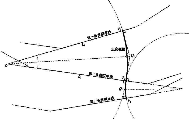
[0047] The coastline of Chongming Dongtan is a typical non-straight coastline, such as Figure 5 As shown, in this example, the data of six time points of 05 / 18 / 1987, 12 / 04 / 1990, 04 / 06 / 1995, 11 / 08 / 1998, 10 / 21 / 2003, and 04 / 20 / 2006 are used. Due to the complex hydrodynamic conditions of this section of the coast, the six coastlines intersect each other.

[0048] Orthogonal section generation method, the steps are as follows:

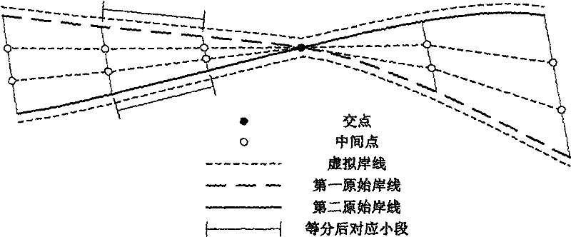
[0049] a) First generate a virtual shoreline, see figure 1 , where the upper and lower outermost virtual shorelines should coincide with the original shorelines. For the convenience of illustration, they have been translated for a certain distance to the upper and lower sides respectively; in...


PUM


Abstract

The invention discloses an orthogonal section method and system for digital shoreline evolution analysis, aiming to provide a section method suitable for different types of shorelines with high degree of automation, reliable calculation results, and effective display of shorelines A system for evolving data information; the present invention uses GIS technology and graphics methods to establish a technical solution by integrating modules such as parameter setting, structural section, calculation statistics, result display, and dynamic simulation, and realizes the automation of the entire business process. Using the method and system can significantly improve work efficiency and business level, and can enhance the comprehensibility of industry data information, and can provide services for estuary and coastal engineering, scientific research fields and related decision-making departments.

Description

technical field [0001] The invention relates to the application technical field of combining GIS (Geographic Information System) and coastal engineering, in particular to an orthogonal section method for calculating shoreline scour-silting evolution analysis and an automatic shoreline evolution analysis system. Background technique [0002] Accurately analyzing and mastering the evolution law of the historical coastline will help to evaluate and predict the changing trend of the coastline in the future, which is of great significance to the planning and management of the coastal zone. Since the geometric shape of the coastline is the result of the comprehensive action of various dynamic elements, in the field of coastal engineering technology, compared with the hydrodynamic model, it becomes an important task to indirectly study the internal coastal erosion process by modeling the change of the coastline. A widely applicable and easy-to-implement method. Moreover, with the ...

Claims


Application Information

Patent Timeline
Patent Type & Authority Patents(China)
IPC IPC(8): G06F17/30
Inventor 李行周云轩袁庆沈宏吴稳
Owner EAST CHINA NORMAL UNIV
Why Eureka
Try Eureka