Automatic classification method of airborne laser radar point cloud data

An airborne lidar, point cloud data technology, applied in electrical digital data processing, special data processing applications, computer parts, etc. good robustness

Inactive Publication Date: 2010-05-05
WUHAN UNIV
View PDF0 Cites 76 Cited by
  • Summary
  • Abstract
  • Description
  • Claims
  • Application Information

AI Technical Summary

Problems solved by technology

Manual classification of point cloud data is inconvenient and inefficien...

Method used


Image

  • Automatic classification method of airborne laser radar point cloud data
  • Automatic classification method of airborne laser radar point cloud data
  • Automatic classification method of airborne laser radar point cloud data

Examples


Embodiment Construction

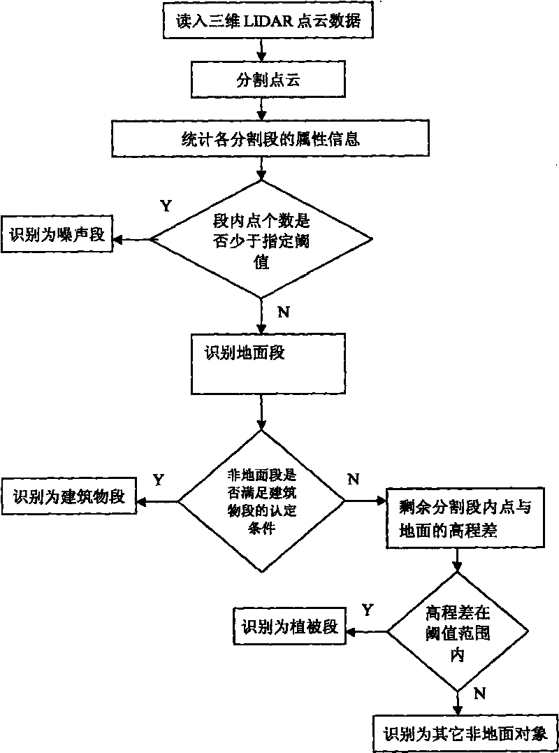
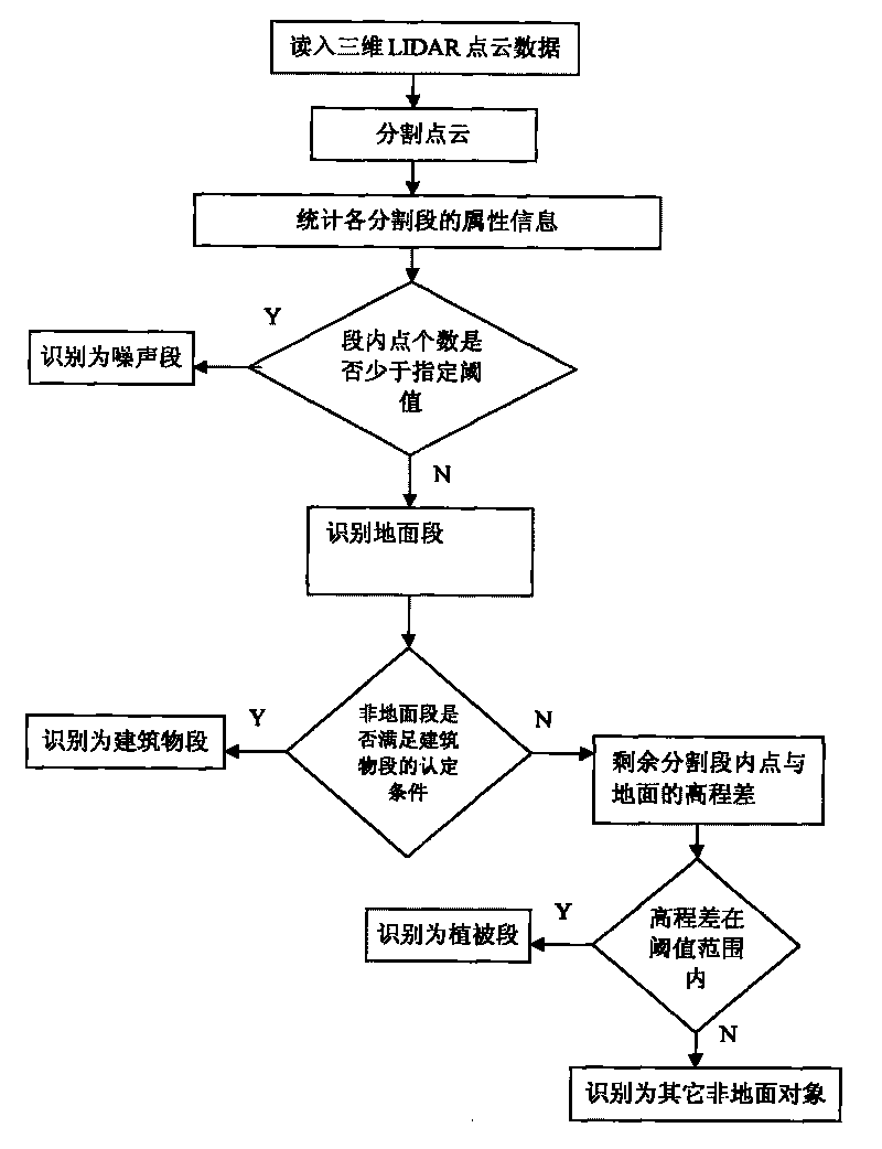
[0019] Specific embodiments of the present invention will be described in more detail below with reference to the accompanying drawings and examples:

[0020] (1) The kd-tree data structure is used to store and manage the 3D lidar point cloud data, which can realize the quick query of the nearest neighbor points of a given point, and the nearest neighbor points are selected according to the Euclidean distance from the query point to the given point. Once the number N of the nearest neighbor points is set, the N neighbor points with the closest Euclidean distance to a given point can be quickly queried through the kd-tree. The kd-tree data structure belongs to the prior art, and will not be described in detail in the present invention. Where k is the dimension of the space, which generally takes values ​​of 2, 2.5, and 3, and the value of 3 is suggested by the present invention.

[0021] (2) Set the maximum slope threshold allowed in the segmentation segment, and cluster and s...


PUM


Abstract

The invention discloses an automatic classification method of airborne laser radar point cloud data, belonging to the technical field of airborne laser radar. In order to improve the efficiency and the precision of the automatic classification of the point cloud data, the method comprises the steps of: firstly, splitting the point cloud data; secondly, counting the each attribute information of splitting segments; and judging the category of the splitting segments according to the spatial space relationship among the splitting segments and the attribute information of the segments. Compared with the existing automatic classification method based on the points, the classification method based on the segments has higher robustness and precision.

Description

technical field [0001] The invention relates to the technical field of airborne laser radar, in particular to an automatic classification method for airborne laser radar point cloud data. Background technique [0002] Airborne LiDAR (Light Detection And Ranging, LIDAR) is a new type of sensor equipment. The device uses laser light for echo ranging and orientation, directly acquiring a set of three-dimensional coordinate points from the measurement surface. LIDAR has a wide range of applications. In recent years, it has played an important role in basic surveying and mapping, digital cities, forest resources and other application fields. The point cloud data obtained by the LIDAR system has high precision and large amount of data, and it is an irregular three-dimensional discrete point data set. Point cloud data not only contains information from bare ground, but also includes information from non-ground object surfaces such as buildings, vegetation, power lines, and vehicl...

Claims


Application Information

Patent Timeline
IPC IPC(8): G06K9/00G06F17/30G01S17/88G01S17/89
Inventor 蒋晶珏姚春静马洪超
Owner WUHAN UNIV
Why Eureka
Try Eureka