Method for remote sensing monitoring and early warning fire in sylvosteppe

A technology of remote sensing monitoring and fire, which is applied in the application field of remote sensing technology, can solve problems such as dependence and limitation, and achieve the effect of improving applicability and assisting scientific formulation

Inactive Publication Date: 2010-06-02
INST OF REMOTE SENSING & DIGITAL EARTH CHINESE ACADEMY OF SCI
View PDF0 Cites 51 Cited by
  • Summary
  • Abstract
  • Description
  • Claims
  • Application Information

AI Technical Summary

Problems solved by technology

Although the acquisition of meteorological observation data has time continuity, and can also reflect the environmental conditions of the fire to indirectly evaluate the state of combustibles, the meteorological observation data from meteorological stations can be used in geographical space, especially in large-scale and complex topographical spaces (such as forest and grassland ecosystems). ) is greatly limited, and must rely on the spatial interpolation analysis of geographic information systems to complete the spatial representation of information

Method used


Image

  • Method for remote sensing monitoring and early warning fire in sylvosteppe
  • Method for remote sensing monitoring and early warning fire in sylvosteppe
  • Method for remote sensing monitoring and early warning fire in sylvosteppe

Examples


Embodiment Construction

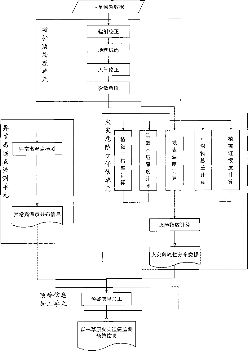
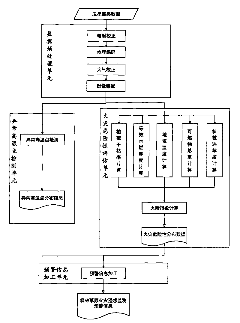
[0018] The present invention utilizes the satellite remote sensing data to carry out the technical flow chart of forest and grassland fire monitoring and early warning as follows figure 1 shown. Using this method, the technical process for remote sensing monitoring and early warning of forest and grassland fires is as follows:

[0019] ① Data preprocessing

[0020] Data preprocessing is to carry out radiation correction, geocoding, atmospheric correction, and image mosaic processing according to the data characteristics of the satellite remote sensing data used, so that it can be transformed into a spatially geocoded image with actual physical meaning (such as reflectivity, radiance, etc.). etc.) data.

[0021] ② Abnormally high temperature point detection unit

[0022] The abnormally high temperature point detection unit uses remote sensing technology to detect multi-band infrared radiation data on the surface, extracts the abnormally high temperature point data on the ear...


PUM


Abstract

The invention discloses a method for remote sensing monitoring and early warning fire in sylvosteppe, belonging to the field of remote sensing technology application. The invention makes full use of the information expressive force of satellite remote sensing data on a large-scale space, comprises fire risk evaluation on the sylvosteppe ecological system in a large-scale range and detection of abnormal high-temperature points in the sylvosteppe on the basis of the remote sensing data, and generates the fire remote sensing monitoring and early warning information for the sylvosteppe in a point-sphere integrated manner by assimilating and processing the detection data (point) on the abnormal high-temperature points and data of fire risk evaluation (sphere), thus providing decisive instruction information for fire protection and fire emergencies of the sylvosteppe. The invention is characterized by comprising four parts of a data pre-treatment unit, an abnormal high-temperature point detection unit, a fire risk evaluation unit and an early warning information processing unit.

Description

technical field [0001] The invention belongs to the application field of remote sensing technology, in particular to a method for monitoring and early warning of forest and grassland ecosystem fires by using remote sensing data. Background technique [0002] my country has a vast territory and is rich in forest and grassland resources. Natural ecosystems such as forests and grasslands play an important role in my country's social and economic development and ecological environment construction. However, due to the influence of climate, terrain and human factors, my country is also a country with frequent forest and grassland fires. Thousands of forest and grassland fires occur every year, and the burning area reaches hundreds of thousands of hectares. Huge losses to life and ecosystems. In forest and grassland fire prevention, establishing and improving a suitable monitoring and early warning mechanism can effectively prevent problems before they happen, reduce the number o...

Claims


Application Information

Patent Timeline
Patent Type & Authority Applications(China)
IPC IPC(8): G08B17/00G06F19/00A62C3/02
Inventor 周艺王世新王丽涛杜聪
Owner INST OF REMOTE SENSING & DIGITAL EARTH CHINESE ACADEMY OF SCI
Why Eureka
Try Eureka