Method for river dredging and management and ait construction
A technology of dredging and construction methods, which is applied to the regulation of rivers and other directions
- Summary
- Abstract
- Description
- Claims
- Application Information
AI Technical Summary
Problems solved by technology
Method used
Image
Examples
Embodiment 1
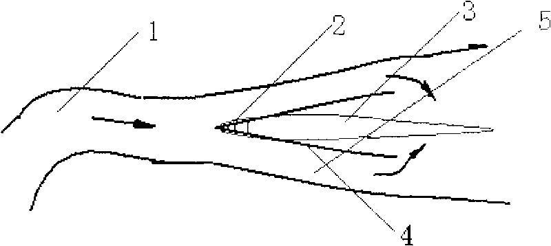
[0023] Example 1: In the Qiantang River, there is a section of river with different widths. Due to the inconsistency of the width and depth of the current, a slow flow area is formed, and the sediment is deposited continuously to form an alluvial island. Alluvial islands are composed of sediment and have a loose structure, so they are very unstable in outline. Whenever there is a flood, the strong erosion will change the shape of the surrounding alluvial island. Under normal circumstances, on both sides of the alluvial island parallel to the river and the tidal current, under the influence of the geostrophic force, one side is always eroded, and the other side is gradually silted up. Over time, long strip islands parallel to the two banks are formed; At both ends, the upstream continues to shrink, and the downstream gradually increases. However, sometimes the entire island is washed away; sometimes the island is close to the mainland and finally joined together. The river is...
Embodiment 2
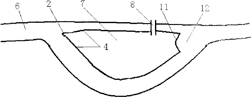
[0025] Embodiment 2 is a certain SY state (7) of the Yangtze River section (6), such as figure 2 As shown, first, a sunken ship is made in the upper reaches of the widening section of the river according to the shape of the nose embankment, and the bottom of the sunken ship is pre-buried with an explosive sinking device, and the sunken ship is pulled to the middle of the widening section of the river with a tugboat, and then lowered after accurate positioning. sink and fix to form a nose embankment, then use hard-shell sheet piles along both sides of the nose to gradually extend downstream according to the shape of the sand ridge, use a vibratory hammer to drive the sheet piles to form a river surface of equal width, and then insert a hard-shell sheet pile (4 ), the sheet piles are connected to each other, and the dredged soil is placed in the enclosing range of the hard shell sheet piles, gradually forming an artificial island. When the hard shell sheet piles (4) are inserted...
Embodiment 3
[0026] Embodiment 3 DT Zhou (10) of Fuchun section (9) in the upper reaches of Qiantang River, as image 3 As shown, first, two hard-shell sheet piles are inserted in the upstream of the gradually widening section of the river according to the shape of the nose dam, and steel bars are used to connect between the sheet piles, and underwater non-dispersible concrete is poured to form the nose dam. Then along both sides of the nose, hard-shell sheet piles are used to gradually extend downstream according to the shape of the sand ridge, and vibratory hammers are used to drive the sheet piles to form a river surface of equal width, and then a hard-shell sheet pile is inserted, and the sheet piles are connected to each other. A spiral-shaped man-made bend (11) is made in the downstream of the narrowing section of the river course, the river surface widens suddenly, the flow velocity drops, and the mud and sand are deposited to form a fixed sand mining point (12). Put the dredged soi...
PUM
 Abstract
Description
Claims
Application Information
 - R&D
- Intellectual Property
- Life Sciences
- Materials
- Tech Scout
- Unparalleled Data Quality
- Higher Quality Content
- 60% Fewer Hallucinations
Browse by: Latest US Patents, China's latest patents, Technical Efficacy Thesaurus, Application Domain, Technology Topic, Popular Technical Reports.
© 2025 PatSnap. All rights reserved.Legal|Privacy policy|Modern Slavery Act Transparency Statement|Sitemap|About US| Contact US: help@patsnap.com


