Method for realizing integrated navigation through ship's inertial navigation system (SINS) and celestial navigation system (SNS)

A strapdown inertial navigation and astronomical navigation technology, applied in the field of integrated navigation, can solve the problems of large attitude error, affecting astronomical positioning accuracy, roughness, etc., and achieve the effect of correct design

Inactive Publication Date: 2010-09-08
NANJING UNIV OF AERONAUTICS & ASTRONAUTICS
View PDF3 Cites 26 Cited by
  • Summary
  • Abstract
  • Description
  • Claims
  • Application Information

AI Technical Summary

Problems solved by technology

[0003] Strapdown inertial navigation system (SINS) refers to an inertial navigation system that directly installs inertial devices (gyroscopes and accelerometers) on the carrier. Compared with platform-type inertial navigation systems, it reduces the inertia of entities. The platform is replaced by the "mathematics platform" stored in the computer, which has many advantages such as low cost, high reliability, easy maintenance, and low failure rate, and has been widel...

Method used


Image

  • Method for realizing integrated navigation through ship's inertial navigation system (SINS) and celestial navigation system (SNS)
  • Method for realizing integrated navigation through ship's inertial navigation system (SINS) and celestial navigation system (SNS)
  • Method for realizing integrated navigation through ship's inertial navigation system (SINS) and celestial navigation system (SNS)

Examples


Embodiment Construction

[0057] Below in conjunction with accompanying drawing, the technical scheme of invention is described in detail:

[0058] Step 1: Astronomical Navigation and Positioning Model Based on SINS Mathematical Platform

[0059] 1 Astro-positioning model

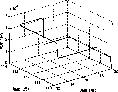
[0060] When discussing astronomical positioning, the earth fixed coordinate system OXYZ is usually used as the reference system. The origin of the coordinate system is the center of the earth, the OX axis passes through the intersection of the Greenwich longitude line and the equator, and the OZ axis points to the direction of the earth's rotation. When positioning, the position in the coordinate system is represented by latitude and longitude, then the equation of the position circle in this coordinate system is

[0061]

[0062] Among them, λ, are the longitude and latitude in the ground-fixed coordinate system, δ A , ω respectively represent the declination and local hour angle of the star, where the local hour angle ω is...


PUM


Abstract

The invention discloses a method for realizing integrated navigation through a ship's inertial navigation system (SINS) and a celestial navigation system (SNS) and belongs to the field of integrated navigation. The invention uses the SINS error mathematic platform as CNS level base and creates a deep combined mathematical model according to the coupling SINS attitude error celestial positioning principle. The method of the invention comprises the following steps: the first step, creating the celestial navigation positioning model based on the SINS mathematic platform; the second step, creating an SINS and CNS combined system model; the third step, performing discretization process through the system state equation and the measuring equation of the created integrated navigation and using a Kalman filter to optimally estimate and verify the inertial navigation error. The inertial/celestial integrated navigation system has excellent autonomy and anti-interference capability. Through the method of the invention, no special level base is needed on the aircraft so as to simplify the design of the SINS/CNS integrated navigation system under an onboard condition.

Description

technical field [0001] The invention relates to a method for realizing integrated navigation of a strapdown inertial navigation system (Strapdown inertial navigation system, SINS) and a celestial navigation system (Celestial navigation system, CNS) in the field of integrated navigation. Background technique [0002] Celestial navigation system (CNS) is an ancient and young technology, which has been widely valued by people for its strong autonomy, good anti-interference, and high precision. The celestial navigation system uses the stars as the source of navigation information, which has good concealment, and can not only provide position information, but also provide high-precision attitude information. Although astronomical navigation was neglected to a certain extent when the satellite navigation system first appeared, as the satellite navigation system exposed defects such as susceptibility to interference, and with the advancement of astronomical sensor technology, ultra...

Claims


Application Information

Patent Timeline
IPC IPC(8): G01C21/16G01C21/02G01C21/20
Inventor 郁丰熊智何真刘建业韩龄华冰屈蔷王丹陈海明
Owner NANJING UNIV OF AERONAUTICS & ASTRONAUTICS
Why Eureka
Try Eureka