Method for rapidly measuring foundation pile control net (CPIII) of rapid transit railway

A technology based on high-speed railways and measurement methods, applied in the direction of measuring instruments, measuring instruments, measuring devices, etc., can solve the problems of weak correlation of CPIII control points and low measurement efficiency, and achieve the goal of overcoming the small overall correlation and good closure , the effect of relatively high precision

Inactive Publication Date: 2010-12-15
扬州德可达科技有限公司
View PDF6 Cites 41 Cited by
  • Summary
  • Abstract
  • Description
  • Claims
  • Application Information

AI Technical Summary

Problems solved by technology

In order to solve the problems of low measurement efficiency of the above CPIII control measurement method and weak correlation between CPIII control points, the present invention adopts a new method based on mobile laser radar measurement and high-speed digital imaging technology, which greatly improves the CPIII network. The measurement efficiency and the overall stability of the control network itself

Method used


Image

  • Method for rapidly measuring foundation pile control net (CPIII) of rapid transit railway
  • Method for rapidly measuring foundation pile control net (CPIII) of rapid transit railway
  • Method for rapidly measuring foundation pile control net (CPIII) of rapid transit railway

Examples


Embodiment Construction

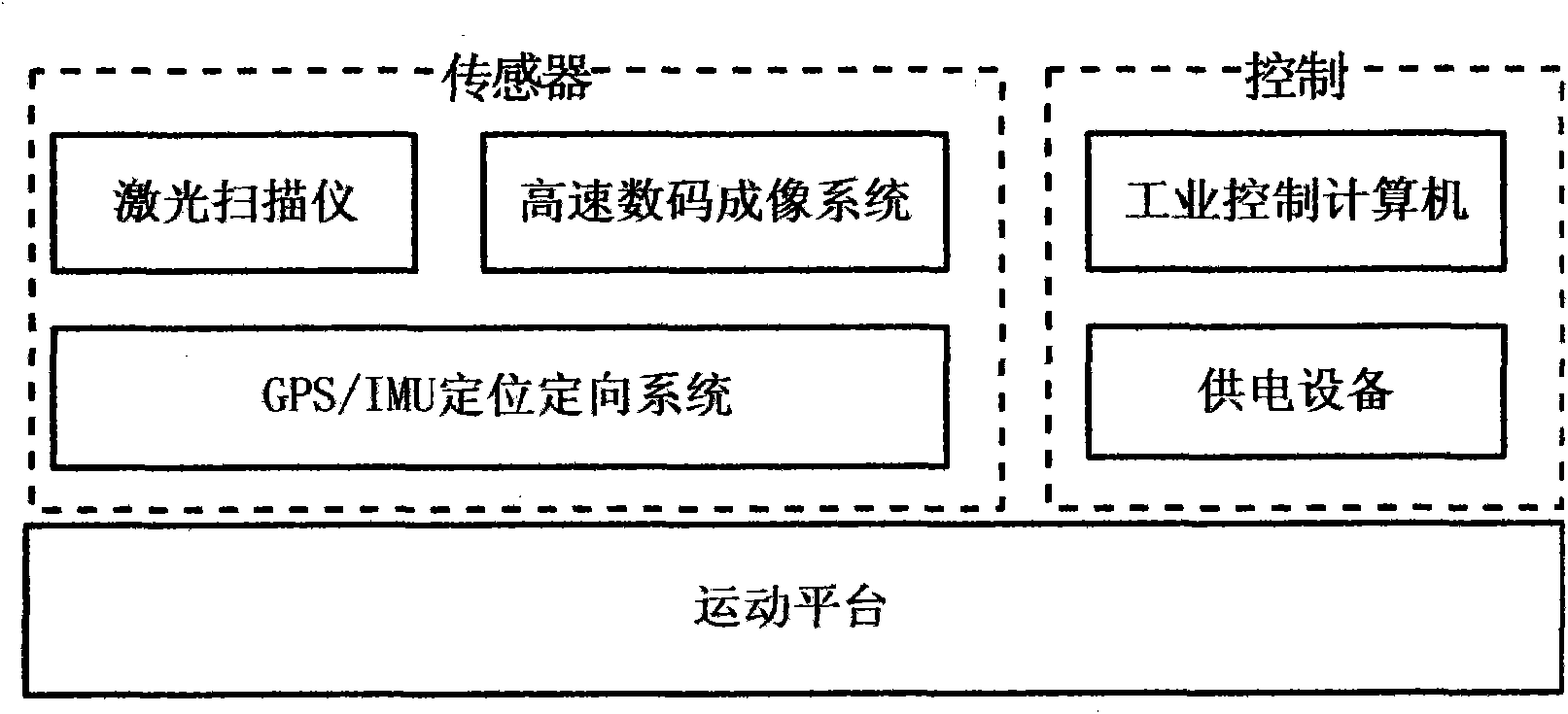
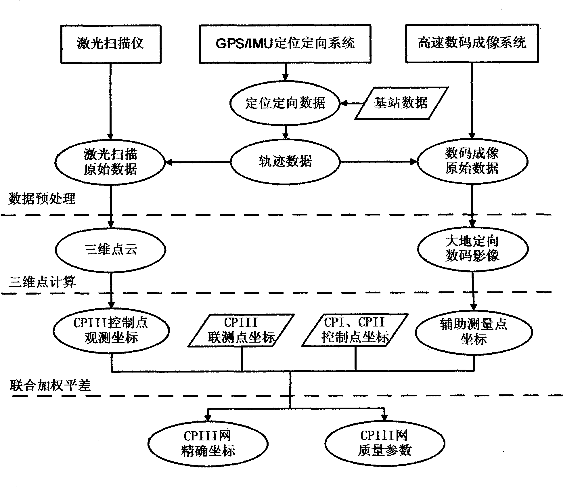
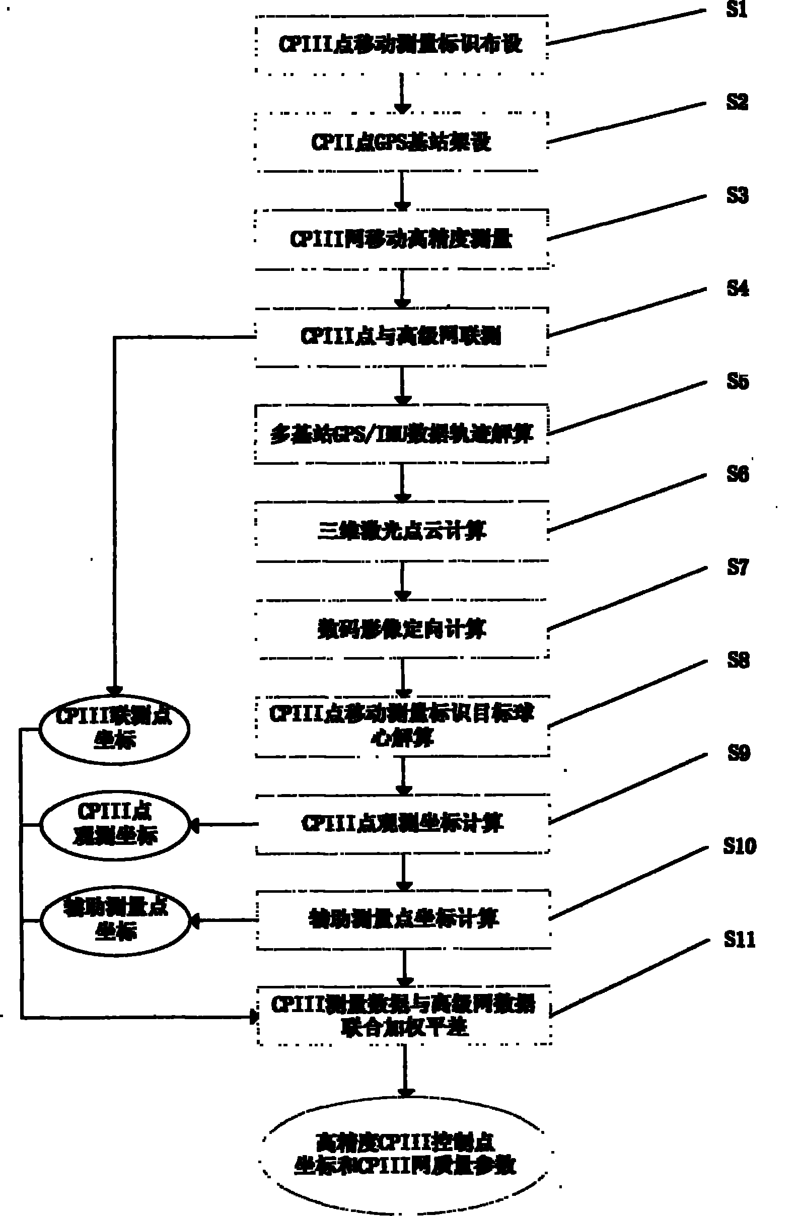
[0019] figure 1 It is a system schematic diagram of the high-speed railway mobile lidar measurement system of the present invention. The system consists of a laser scanner (1), a GPS / IMU positioning and orientation system (2), a high-speed digital imaging system (3), an industrial computer (4) and a power supply device (5). The power supply device (5) provides power guarantee for the laser scanner (1), the GPS / IMU positioning and orientation system (2), the high-speed digital imaging system (3), and the industrial computer (4). The laser scanner (1), the GPS / IMU positioning and orientation system (2), and the high-speed digital imaging system (3) are controlled by an industrial computer (4). The system is installed on the motion platform. During the motion, the laser scanner (1) emits the laser beam and receives the reflected laser pulse, and the GPS / IMU positioning and orientation system (2) obtains the positioning and orientation data at each moment of the movement. , the ...


PUM


Abstract

The invention relates to the field of precise engineering survey, in particular to a method for rapidly measuring a foundation pile control net (CPIII) of a rapid transit railway on the basis of movable laser radar measuring technology and high-speed digital imaging technology. control net (CPIII) measurement data is obtained by using a movable high-precision measurement system comprising a laser scanner (1), a GPS/IMU positioning and orientating system (2), a high-speed digital imaging system (3), an industrial computer (4) and a power supply device (5); and united weighted adjustment is carried out on advanced net data, united measured data and auxiliary measurement points extracted from images to obtain high-precision control net (CPIII) control point coordinates. The invention can greatly shorten the measurement time of the control net (CPIII), overcomes the defect of little total correlation of discrete single-point measurement, carries out integral adjustment on all control points, has good closing property and high relative precision, obtains plane and elevation coordinates of all control points, and greatly simplifies the measurement work of the control net (CPIII).

Description

technical field [0001] The invention relates to the field of precision engineering measurement, in particular to a fast measurement method for a high-speed railway foundation pile control network CPIII based on mobile laser radar measurement and high-speed digital imaging technology. Background technique [0002] The high-speed railway engineering measurement control network is divided into three levels, the first level is the basic control network (CPI network), the second level is the line control network (CPII network), and the third level is the foundation pile control network (CPIII network). National coordinate system. The CPIII network mainly provides control references for track laying and operation and maintenance. The control points are arranged in pairs at intervals of 40-60 meters along the line, and the distance between each pair of control points is about 15 meters. The CPIII control measurement is at the CPII coordinates of the line control network Based on t...

Claims


Application Information

Patent Timeline
Patent Type & Authority Applications(China)
IPC IPC(8): E01B35/00G01C15/00
Inventor 唐粮
Owner 扬州德可达科技有限公司
Why Eureka
Try Eureka