Air-fleet inertial navigation data fusion method based on mutual ranging information

An inertial navigation and data fusion technology, applied in the field of navigation and positioning, can solve problems such as difficulty in working independently for a long time, unavailability, accumulation of navigation and positioning errors, etc., and achieve the effect of easy calculation and strong robustness.

Inactive Publication Date: 2011-11-09
BEIHANG UNIV
View PDF0 Cites 1 Cited by
  • Summary
  • Abstract
  • Description
  • Claims
  • Application Information

AI Technical Summary

Problems solved by technology

The inertial navigation system can continuously provide a variety of high-precision navigation parameter information, with a wide frequency band and strong autonomy. The main disadvantage is that navigation and positioning errors accumulate over time, making it difficult to work independently for a long time; capability, but GPS is susceptible to interference and faces the problem of unavailability in wartime
Therefore, there are serious defects in the current technical means of transmitting the data of the inertial / GPS integrated navigation system through the airborne data link for group networking and cooperative air combat

Method used


Image

  • Air-fleet inertial navigation data fusion method based on mutual ranging information
  • Air-fleet inertial navigation data fusion method based on mutual ranging information
  • Air-fleet inertial navigation data fusion method based on mutual ranging information

Examples


Embodiment Construction

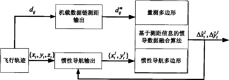
[0017] The present invention first determines the use of the inertial navigation data fusion system based on mutual ranging information, then uses the corresponding inertial navigation data and mutual ranging information to determine the inertial navigation polygon and the measurement polygon, and then compares the inertial navigation polygon to the measurement polygon Perform translation and rotation, and finally estimate the inertial navigation position error. The basic principle is as follows figure 1 As shown, the specific steps are as follows:

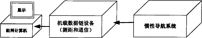
[0018] 1. Adopt an inertial navigation data fusion system based on mutual ranging information, such as figure 2 As shown, each network node needs to be equipped with a set of airborne data link, a set of inertial navigation system and a set of networking computer. During the working process, the inertial navigation data is transmitted to the airborne data link, and the transmitted inertial navigation data includes the status wor...


PUM


Abstract

The invention relates to an air-fleet inertial navigation data fusion method based on mutual ranging information, wherein the inertial navigation positioning error of each node of an air fleet is estimated by considering the characteristic that the positioning error of an inertial navigation system basically obeys normal distribution, utilizing the mutual ranging information and the inertial navigation data among the nodes of the air fleet, obtained by an airborne data link, and using a geometric graph translating-rotating data fusing method, and thus, the air-fleet inertial navigation position precision can be improved by about 1 / 2. The invention effectively combines an airborne data link system and the inertial navigation system through the data fusing method according to the characteristic that the ranging precision of the airborne data link is superior to the ranging of the inertial navigation system, and successfully solves the accurate navigation problem of each node of the air fleet when no GPS (Global Positioning System) exists under the condition of confrontation between systems.

Description

technical field [0001] The invention relates to a data fusion method for fleet inertial navigation based on mutual ranging information, which can correct the inertial navigation position error of each node in the fleet under the condition of "system confrontation" without GPS, and belongs to the technical field of navigation and positioning. Background technique [0002] With the development of information technology, especially wireless communication technology and computer technology, the form of warfare has changed from a confrontation between "platforms" such as weapons and weapons to a confrontation between "systems" and "systems". Under such conditions, modern large-scale air battles are usually carried out by fleets of early warning aircraft, fighter jets, electronic warfare aircraft, and air tankers. Small-scale air battles are also coordinated actions of the aircraft in the formation. Therefore, in Under the condition of system confrontation, in order to effectively...

Claims


Application Information

Patent Timeline
Patent Type & Authority Patents(China)
IPC IPC(8): G01C21/20G01C21/16
Inventor 张京娟刘俊成冯培德
Owner BEIHANG UNIV
Why Eureka
Try Eureka