Real-time self-investigation new path generating method of vehicle-mounted navigation map

A vehicle navigation and map technology, which is applied to road network navigators, traffic control systems of road vehicles, instruments, etc., can solve the problems of poor accuracy, errors, and higher storage capacity requirements for new roads, and achieves improved similarity and convenient implementation. , the effect of ensuring smoothness and continuity

Active Publication Date: 2011-04-27
TSINGHUA UNIV
View PDF5 Cites 16 Cited by
  • Summary
  • Abstract
  • Description
  • Claims
  • Application Information

AI Technical Summary

Problems solved by technology

The European ActMap project has realized online incremental update in some countries; while my country currently mainly adopts the offline update method, and the update cycle is 6 to 12 months. This update method is far from satisfying the reality of the navigation system for electronic maps. needs
[0003] Utilizing vehicle trajectories to update map data can realize rapid update of electronic maps. There are two main methods for using vehicle trajectories to update map road networks: one method is to generate the entire road network from the collected trajectories, and the recorder collects vehicle The location information of all the track points passed by the track forms the entire road network through the processing of the track. This map update method records all the track points passed by the vehicle, which requires high storage capacity of the equipment and is not suitable for existing The vehicle-mounted embedded navigation device; another method is to generate a local road network from the collected trajectory, and compare the local road network with the existing map road network in an image or digital way. If the road network is inconsistent, use the local road network to update the original road network. The corresponding road network of the road network, this map update method does not involve the discovery of new roads, and still records all the track points passing by; in addition, this method uses the track generated by the shape points obtained by GPS (Global Positioning System) directly as Local road network data does not consider the influence of GPS signal drift on the rationality and shape of the path trajectory, and the accuracy of the generated new road is poor or even wrong

Method used


Image

  • Real-time self-investigation new path generating method of vehicle-mounted navigation map
  • Real-time self-investigation new path generating method of vehicle-mounted navigation map

Examples


Embodiment Construction

[0031] The present invention will be described in detail below in conjunction with the accompanying drawings and embodiments.

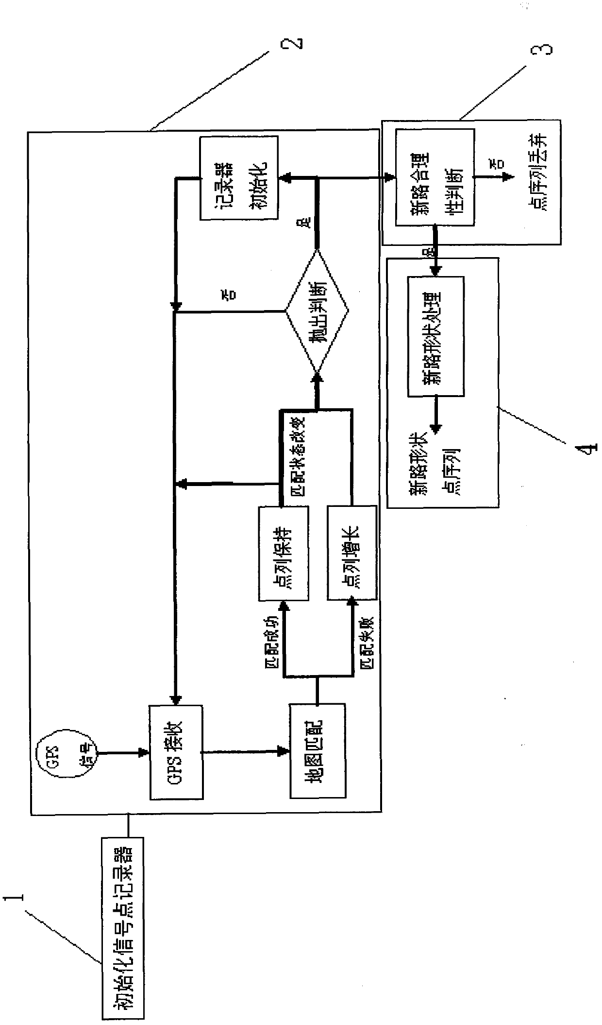
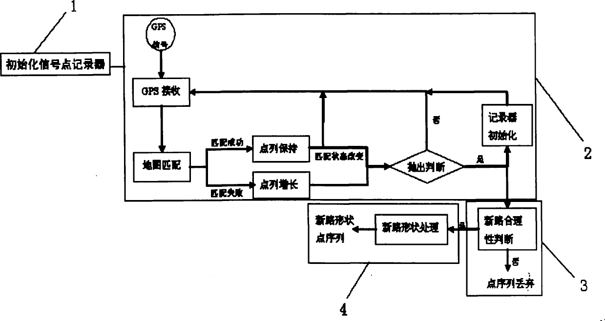
[0032] Such as figure 1 As shown, in the vehicle running process, the present invention comprises the following steps:

[0033] 1) Set up a signal point recorder in the navigation system, and automatically record a signal point information after the signal point recorder starts;

[0034] 2) The signal point recorder records and refreshes the signal points in real time, and completes the adding process;

[0035] 3) Based on the time criterion and the distance criterion, the rationality judgment is made on the signal point sequence of the added path;

[0036] 4) In the embedded navigation device, the Kalman filter and the point-sequence thinning algorithm are used to perform real-time smoothing processing on the path-adding shape points.

[0037] The specific implementation methods of the above steps are described as follows:

[0038] Step 2) The re...


PUM


Abstract

The invention relates to a real-time self-investigation new path generating method of a vehicle-mounted navigation map, which is characterized by comprising the following steps in the vehicle running process: (1) arranging a signal point recorder which automatically records the information of a signal point after being started; (2) recording and refreshing the signal point in real time through the signal point recorder, and finishing a path increasing process; (3) judging the rationality of the signal point sequence of the increased path based on the time criterion and the distance criterion;and (4) carrying out real-time smooth processing on the signal point sequence of the increased path by utilizing a Kalman filtering algorithm and a point range thinning algorithm in embedded navigation equipment. The invention ensures the accurate recognition of the newly increased path of the map in the vehicle running process, reduces the influence on the shape of a section of path by drift or loss of GPS (global positioning system) signals, generates a relatively accurate signal point sequence, and establishes the foundation for real-time self-updating operation of the map.

Description

technical field [0001] The invention relates to a method for updating a navigation map, in particular to a new road generation method for real-time self-examination of a vehicle navigation map. Background technique [0002] With the continuous development of the vehicle industry, my country's transportation infrastructure is also undergoing rapid changes. Therefore, if the autonomous navigation system based on the vehicle electronic map does not update the map in time, it will not be able to provide good navigation services due to the expiration of the map data. At present, there are mainly two methods for updating the navigation electronic map: an offline version update method and an online incremental update method. The European ActMap project has realized online incremental update in some countries; while my country currently mainly adopts the offline update method, and the update cycle is 6 to 12 months. This update method is far from satisfying the reality of the naviga...

Claims


Application Information

Patent Timeline
Patent Type & Authority Applications(China)
IPC IPC(8): G01C21/30G08G1/0969
Inventor 杨殿阁连小珉张照生李挺王钊张涛杨扬李克强
Owner TSINGHUA UNIV
Why Eureka
Try Eureka