Positioning method and terminal

A positioning method and technology of positioning method, applied in the field of positioning and navigation, can solve problems such as the inability to meet indoor navigation and positioning, and achieve the effects of improving user experience, reducing positioning delay time, and improving positioning accuracy

Inactive Publication Date: 2011-05-25
ZTE CORP
View PDF4 Cites 69 Cited by
  • Summary
  • Abstract
  • Description
  • Claims
  • Application Information

AI Technical Summary

Problems solved by technology

In fact, even if some more advanced positioning methods are used, such as the A-GPS (Assisted GPS, assisted GPS) method that combines GPS and base station positioning for joint positioning, the indoor positioning accuracy is only in the range of 20 to 50 meters. Far from meeting the needs of indoor navigation and positioning

Method used


Image

  • Positioning method and terminal
  • Positioning method and terminal
  • Positioning method and terminal

Examples


example 1

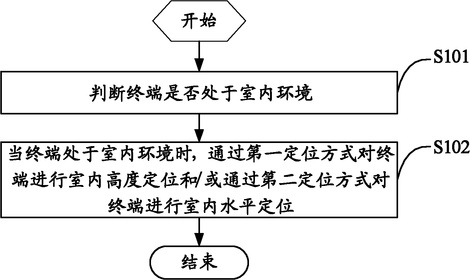
[0087] Example 1. When performing indoor positioning, the terminal uses a barometric altimeter for altitude positioning (or fixed altitude, that is, calculates the height of the terminal). Since the barometric altimeter calculates the altitude from the air pressure based on the function between the air pressure and the altitude, and The air pressure is also affected by the atmospheric environment (such as temperature and humidity) where the terminal is located. In order to correct / calibrate the error of the barometric altimeter, the following methods can be used:

[0088] 1) The method of manual correction / calibration is used, that is, the user himself calibrates the barometric altimeter according to the known altitude of a certain reference point before using the barometric altimeter to determine the altitude. For example, if the user has just turned on the positioning function in a certain building or building, the user can manually input the current floor (such as the first ...

example 2

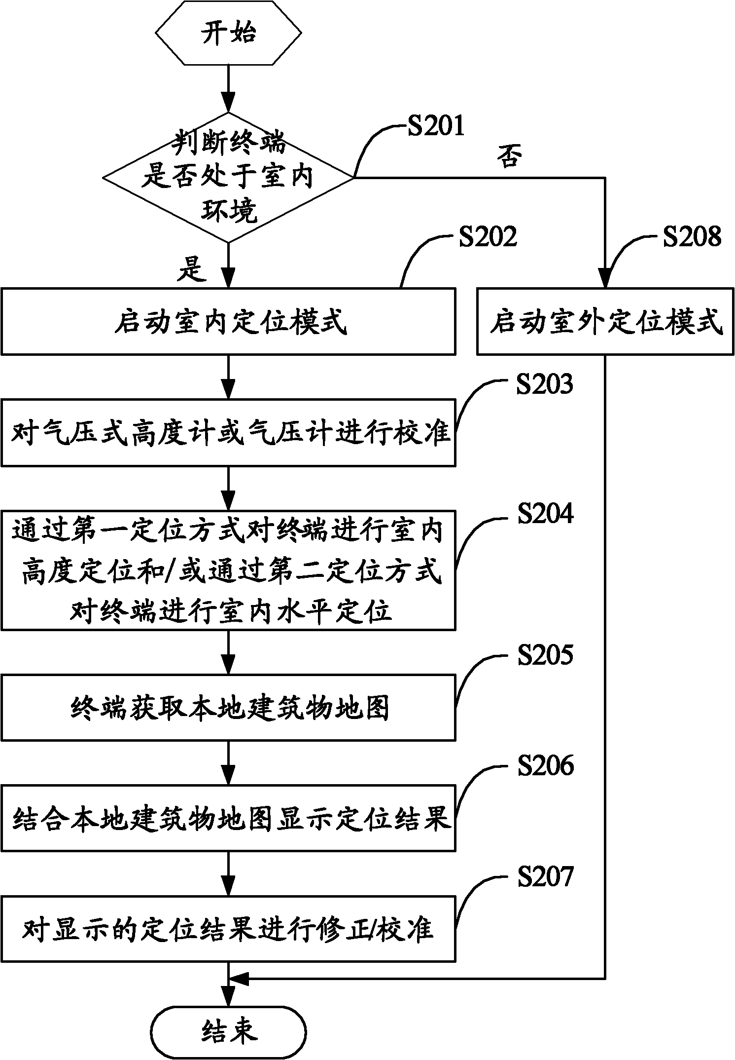
[0091] Example 2. The terminal has GPS capability and / or base station positioning capability (such as the LCS capability specified by the 3GPP standards organization), and also has the function of an electronic altimeter. When the terminal enters the room from the outside or after entering the room, the user can manually choose to open the indoor Positioning mode / function (the terminal can distinguish between outdoor positioning mode / function and indoor positioning mode / function for users to choose and use. In this case, in other words, the terminal has an outdoor positioning mode or an indoor positioning mode). After the indoor positioning mode is turned on, the terminal measures the height of the current terminal (user) through the electronic altimeter, and this height may be represented by altitude or relative height. On the other hand, the user can pre-store the map of the building in the terminal or obtain the map of the building through a nearby base station. After combi...

example 3

[0099] Example 3: The terminal has GPS capability or base station positioning capability (such as LCS capability specified by the 3GPP standard organization) or A-GPS capability, and also has the function of an electronic altimeter. The user may turn on the positioning function at any position (the terminal does not distinguish between outdoor positioning mode and indoor positioning mode, or the user selects the automatic mode), then first use the terminal's GPS positioning function, base station positioning function or A-GPS positioning function to obtain a rough location (with an accuracy of 10 meters to 50 meters), and combined with the map to determine whether the terminal is in an outdoor environment or an indoor environment. If it is determined that the terminal is in an indoor environment, the indoor positioning mode is started. The height measurement by the electronic altimeter is similar to example 1 or 2, the height measurement function can be corrected by a series o...


PUM


Abstract

The invention relates to a positioning method and a terminal. The method comprises the following steps of: judging whether the terminal is in an indoor environment or not; and when the terminal is in the indoor environment, positioning the indoor height of the terminal by a first positioning mode and/or positioning the indoor level of the terminal by a second positioning mode. The indoor height of the terminal is positioned by a pneumatic height gauge or an air pressure gauge and/or the indoor level of the terminal is positioned in combination with a height positioning result. By the two positioning modes, the problem of different requirements on height, the positioning accuracy of a horizontal plane and positioning delay time in indoor navigation positioning service is solved, positioning accuracy is enhanced, positioning delay time is shortened, user experience of indoor navigation positioning is improved and various application requirements of indoor navigation positioning and the like are met.

Description

technical field [0001] The present invention relates to the technical field of positioning and navigation, in particular to a positioning method and a terminal. Background technique [0002] Radio positioning and navigation technology has been widely used in the commercial field, mainly including satellite positioning technology, such as Global Positioning System (Global Positioning System, GPS), base station positioning technology, such as in 3GPP (3rd Generation Partnership Project, the third generation partner) LCS (Location Service) and LPP (LTE Positioning Protocol) launched by the organization or LBS (Location-Based Service) launched by IEEE802.16e / m, wireless positioning technology based on wireless local area network or personal network, such as WIFI (Wireless Fidelity, wireless broadband ), Bluetooth, infrared positioning technology, etc., and radio frequency identification (Radio Frequency Identification, RFID) positioning technology. These positioning technologie...

Claims


Application Information

Patent Timeline
Patent Type & Authority Applications(China)
IPC IPC(8): H04W12/06H04W64/00G01S5/02H04W12/08
CPCG01S19/48G01C21/206H04W64/00G01C5/06
Inventor 谢峰祝建建陈琳黄莹
Owner ZTE CORP
Why Eureka
Try Eureka