Real-time land cluster survey method

A land and cluster technology, applied in special data processing applications, instruments, electronic digital data processing, etc., can solve problems such as long operation cycle, high labor intensity, and inability to quantitatively analyze, so as to reduce labor intensity and cost, and reduce manpower and material resources , The effect of shortening the investigation time

Inactive Publication Date: 2011-06-15
SOUTHEAST UNIV
View PDF0 Cites 33 Cited by
  • Summary
  • Abstract
  • Description
  • Claims
  • Application Information

AI Technical Summary

Problems solved by technology

The disadvantages of the data collection and processing process are: (1) the collected data must be processed by GPS / PDA handset, which takes a long time, slow speed and high cost; (2) when the measured land area is relatively large, labor High intensity and high technical requirements for personnel; (3) On-site quantitative analysis of the area that needs to be investigated cannot be performed in real time, and the investigation results cannot be output in time, and the operation cycle is relatively long; (4) The business application terminal cannot grasp the real-time information of the field data collection terminal The monitoring situation is not conducive to fine management; (5) The GPS / PDA all-in-one machine has a large workload for data calculation, statistics, and sorting, it is difficult to form systematic data, and the sharing of land survey and monitoring data is poor;

Method used


Image

  • Real-time land cluster survey method
  • Real-time land cluster survey method
  • Real-time land cluster survey method

Examples


Embodiment Construction

[0029] The working principle and specific implementation process of the present invention will be further described below in conjunction with the accompanying drawings.

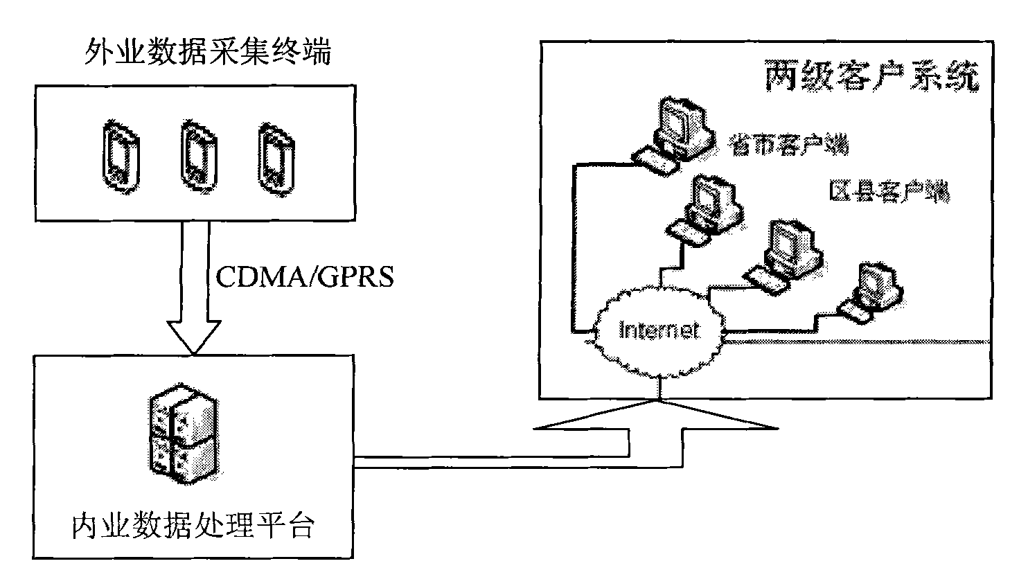
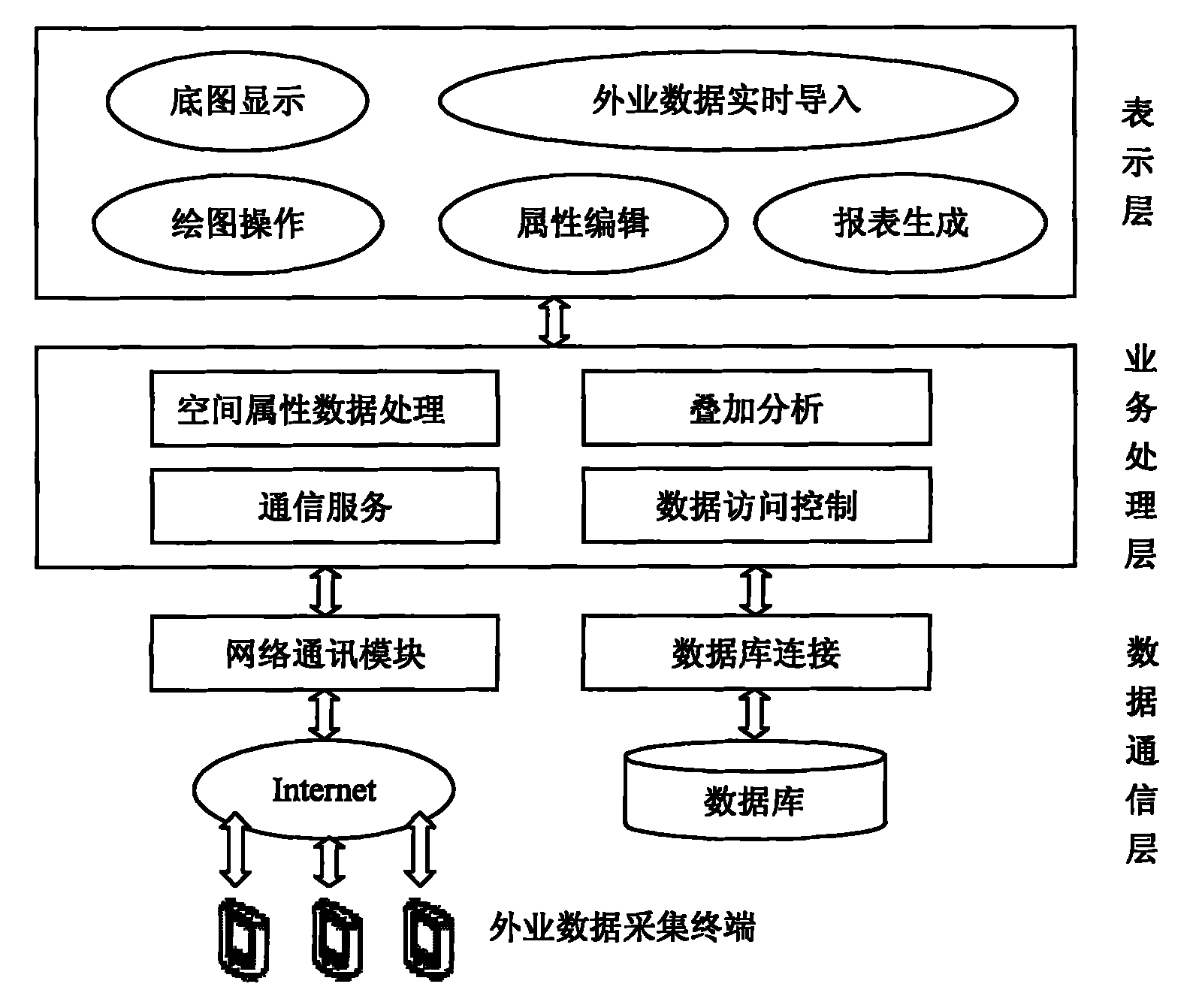
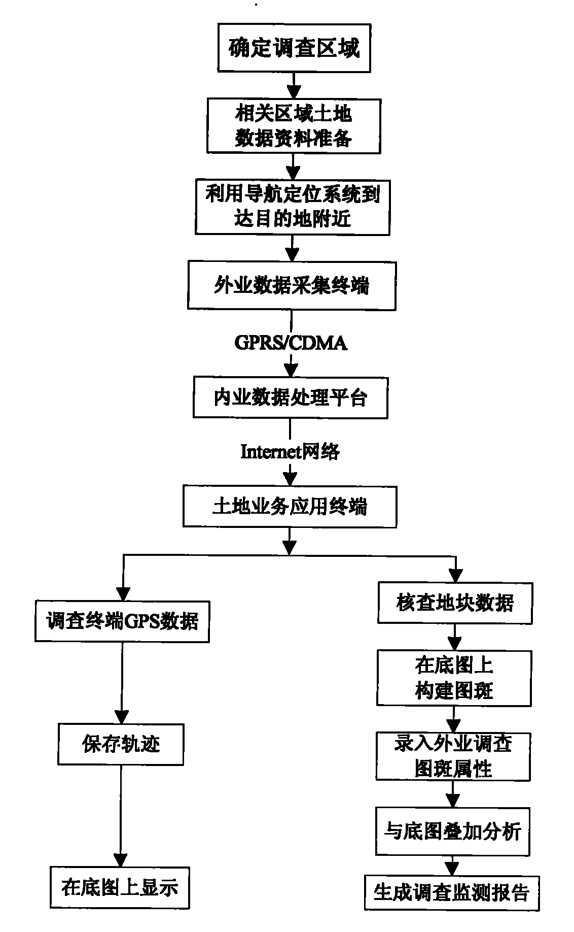
[0030] like figure 1 As shown, the land cluster survey and monitoring operation system consists of multiple field data collection terminals, an internal data processing platform and multiple business application terminals. The field data collected by GPS / PDA and the GPS data for monitoring and positioning purposes of multiple land surveys are uploaded to the internal data processing platform in real time in a standardized data definition format and TCP / IP network protocol; the internal data processing platform Data classification; multiple business application terminals publish the spatial data and attribute data in the entire database, browse, analyze, generate reports, etc. for download and use by provincial and municipal clients and district and county clients, and finally establish a multi-purpose termina...


PUM


Abstract

The invention relates to a real-time land cluster survey method. The method comprises the following steps: with an office data service platform as a center, firstly sending the filed data acquired by virtue of GPS/PDA (global positioning system/personal digital assistant) and GPS (global positioning system) data used for monitoring and positioning in a field data acquisition subsystem to a real-time communication service system in a standard data definition format by virtue of the TCP/IP (transmission control protocol/internet protocol) network protocol; classifying the obtained data by the office data server; and issuing spatial data and attribute data in the whole database by a service terminal, and browsing and analyzing to generate a report for use of a user, thus the real-time cluster survey monitoring on the land is realized finally.

Description

technical field [0001] The invention relates to a technical method of state-owned land survey, in particular to a real-time land cluster survey method for realizing regional cluster survey and monitoring and providing network technical support for land survey and monitoring. Background technique [0002] Comprehensive, timely and accurate grasp of land use information is the basis for the preparation of land use planning, strict land management, protection of cultivated land, intensive and economical use of land, and participation in macro-control. The premise is strategic work related to the overall situation. With the rapid development of urbanization and industrialization, the rapid expansion of urban boundaries, the large-scale demolition and construction of cities, the accelerated development of transportation, water conservancy and other basic construction, land use types, spatial geometry, and ownership information are changing more and more frequently. At the same t...

Claims


Application Information

Patent Timeline
Patent Type & Authority Applications(China)
IPC IPC(8): G06F19/00G06F17/30
Inventor 王庆潘树国王姗姗
Owner SOUTHEAST UNIV
Why Eureka
Try Eureka