
Nuclear hazard forecasting and alarming platform and method based on GIS (Geographic Information System)

A technology for nuclear hazards and nuclear accidents, applied in prediction, ICT adaptation, instruments, etc.

Active Publication Date: 2011-06-15
中国人民解放军防化指挥工程学院
View PDF4 Cites 12 Cited by
  • Summary
  • Abstract
  • Description
  • Claims
  • Application Information

AI Technical Summary

Problems solved by technology

Once a nuclear facility is attacked, there will be serious consequences

Method used


Image

  • Nuclear hazard forecasting and alarming platform and method based on GIS (Geographic Information System)
  • Nuclear hazard forecasting and alarming platform and method based on GIS (Geographic Information System)
  • Nuclear hazard forecasting and alarming platform and method based on GIS (Geographic Information System)

Examples


Embodiment Construction

[0048] The present invention will be further described below in conjunction with the accompanying drawings and embodiments.

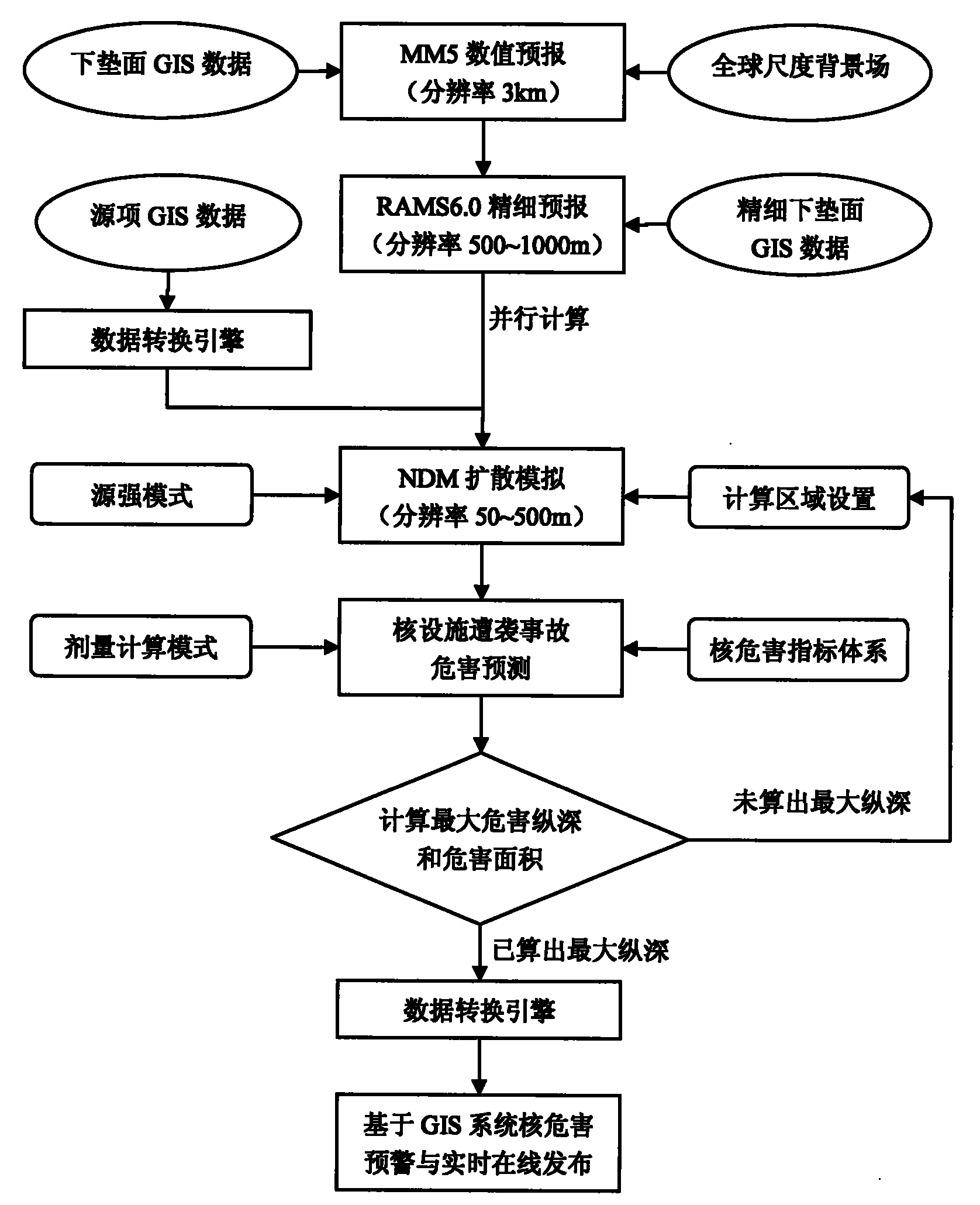
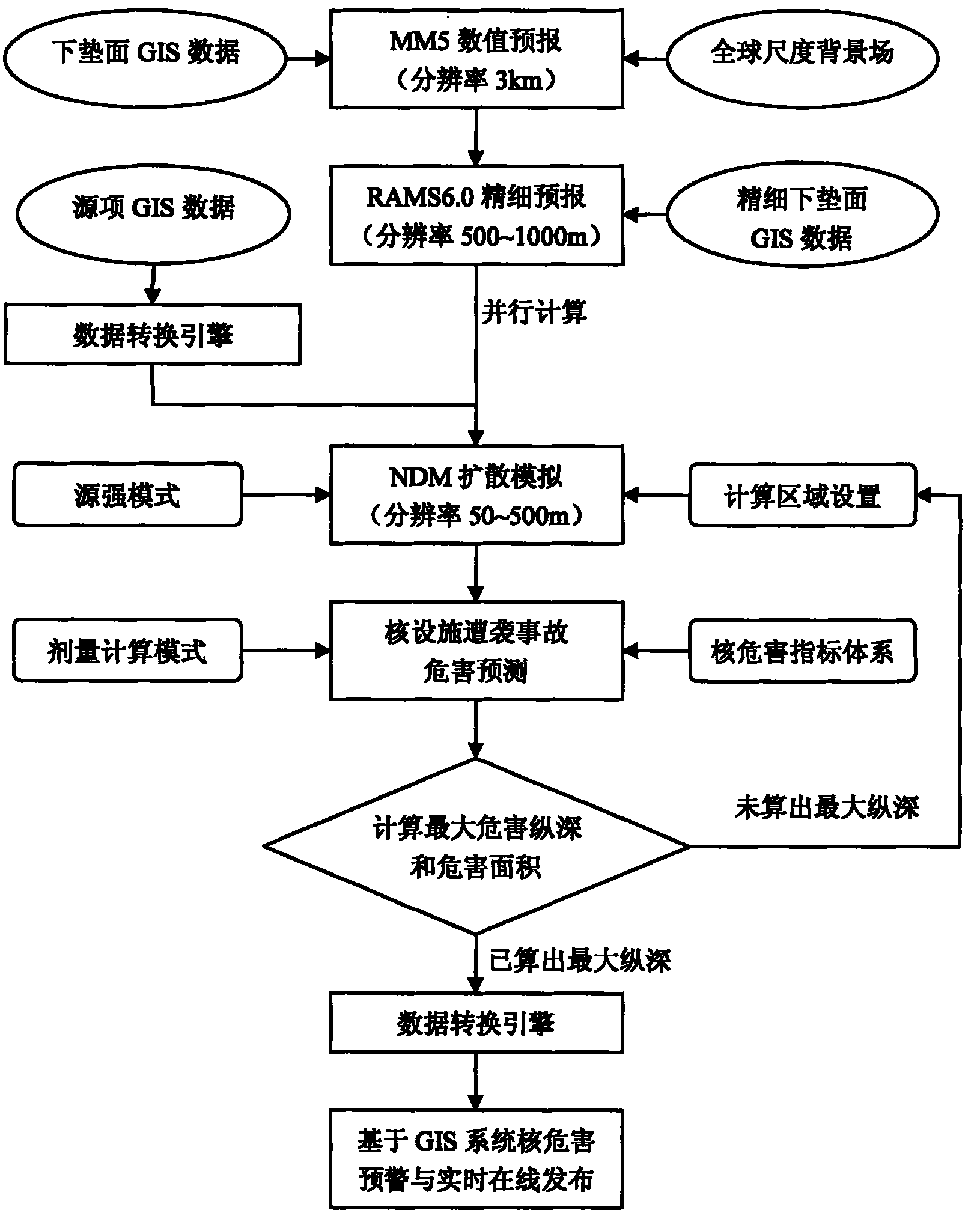
[0049] The schematic flow chart of the inventive method is as figure 1 As shown, the specific operation steps are as follows:

[0050] Step 1: Obtain the forecast results of wind field and turbulence.

[0051] First, the mesoscale model MM5 is used to forecast the meteorological field in the target area.

[0052] The global-scale background field T213 is used as the initial field of MM5, and the coordinates of the target simulation area are input or selected through multi-layer grid nesting. The MM5 system automatically calls the GIS data in the target simulation area as boundary conditions, and MM5 calculates in parallel by scrolling , to forecast the meteorological field of the target area in the next 36 hours, including wind field, turbulence, temperature field, pressure field, etc., with a resolution of 3km.

[0053] Then, the regional atmospheri...


PUM


Abstract

The invention discloses a nuclear hazard forecasting and alarming platform and method based on a GIS (Geographic Information System), belonging to the field of hazard control. The nuclear hazard forecasting and alarming method comprises the following steps of: 1.obtaining forecasting results of a wind field and a turbulence flux; 2. carrying out proliferation simulation on a nuclear hazard; 3. obtaining hazard depth, withdrawing depth, iodine taking depth, hazard area, withdrawing area, iodine taking area, hazard start time and hazard duration time of a nuclear accident; 4. judging whether the hazard depth of the nuclear accident in a set proliferation simulation region is figured out, if the hazard depth is figured out, ending the method, and if the hazard depth is not figured out, returning to the step 2; and 5. forecasting and alarming the nuclear hazard based on the GIS and issuing online in real time. The invention provides a data support for dealing with nuclear crisis, providesa scientific basis for rapidly dealing with the nuclear crisis, and scientifically evaluating the result of the nuclear hazard, thereby guiding the public to rapidly take correct safeguard measures after the public are attacked, eliminating psychological pressure and unnecessary worry and guaranteeing the social stability and the everyday routines.

Description

technical field [0001] The invention relates to a nuclear hazard prediction and early warning platform and method based on a GIS system, belonging to the field of hazard control. Background technique [0002] Since the Chernobyl nuclear accident, the disastrous nature of nuclear accidents has left a deep imprint on the world. At present, the world is not peaceful, and nuclear threats still exist, especially the North Korean nuclear crisis that has attracted the attention of the world many times. Nuclear threats have been put on the agenda time and time again, posing potential hazards to my country's national security and people's health. Once a nuclear facility is attacked, it will have serious consequences. How to carry out hazard prediction and early warning for nuclear facility attacks is the key to reducing the hazards of nuclear facility attacks and reducing accident losses. Therefore, it is very necessary to conduct systematic research on the prediction and early war...

Claims


Application Information

Patent Timeline
IPC IPC(8): G06Q50/00G06Q10/04
CPCY02A90/10
Inventor 黄顺祥符天保王永红周学志桑萌赵远刘峰张文丽
Owner 中国人民解放军防化指挥工程学院
Learn More