
Cloud recognition method of three-dimensional laser scanning point in geological body structural plane

A 3D laser and structural surface technology, applied in image data processing, 3D modeling, instruments, etc., can solve problems such as poor data accuracy, incomplete results for structural surface recognition, and low efficiency

Inactive Publication Date: 2011-06-15
POWERCHINA XIBEI ENG +1
View PDF1 Cites 23 Cited by
  • Summary
  • Abstract
  • Description
  • Claims
  • Application Information

AI Technical Summary

Problems solved by technology

This method not only has a large workload and low efficiency, but sometimes the accuracy of the data obtained is also poor.
With the increasing demand for energy from social development, China's hydropower construction is in the ascendant in recent years. Hydropower development is often carried out in high mountains and valleys. Due to the high mountains and steep slopes, the preliminary survey work for hydropower construction is difficult and dangerous, because the slope is too high and steep and the site The road is simple, and there are many difficulties in obtaining a large amount of geological survey information, such as the spatial distribution shape, position, scale, and occurrence of controlling structural planes of rock mass
The three-dimensional laser scanning technology is to obtain the three-dimensional data of the surface of the geological body. What the three-dimensional laser scanning can obtain is only the exposed part of the structural surface. It uses the high-density point cloud to reflect the spatial state of the structural surface. Therefore, the identification of the structural surface cannot give complete results

Method used


Image

  • Cloud recognition method of three-dimensional laser scanning point in geological body structural plane
  • Cloud recognition method of three-dimensional laser scanning point in geological body structural plane
  • Cloud recognition method of three-dimensional laser scanning point in geological body structural plane

Examples


Embodiment Construction

[0033] The characteristics of the structural surface recognition method in point cloud data are summarized as follows:

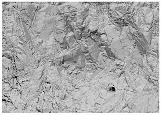
[0034] (1) Direct identification of structural planes. This type of structural surface has obvious characteristics, stable occurrence, and partial opening. According to the surface conditions, those structural surfaces with obvious exposure can be easily identified on the scanned image (see attached figure 1 ), such structural planes can be directly identified in point cloud data;

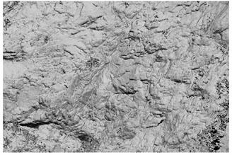
[0035] (2) Analogy identification of structural planes. This type of structural surface has no obvious characteristics, is generally small in scale, closed, and has a certain change in occurrence, and the exposed surface of the ground is small or non-existent. This type of structural surface can be based on the characteristics that appear in groups, and on the basis of structural surfaces with obvious characteristics. It conducts analogy judgment (as attached figure 2 );

[...


PUM


Abstract

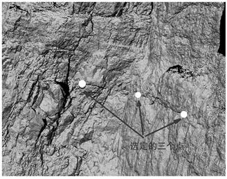
The invention belongs to the technology of acquiring geological structural plane information and particularly relates to a cloud recognition method of a three-dimensional laser scanning point in a geological body structural plane, which is characterized by comprising the following steps of, firstly, determining a geological body structural plane range needing scanning; secondly, determining a plane of the geological body structural plane range needing scanning through three point coordinates which are not on the same line; thirdly, scanning the three point three-dimensional coordinates of the geological body structural plane through a three-dimensional laser, and acquiring a plane equation; fourthly, for rough fluctuation and topography of the determined structural plane, scanning all points on an exposed plane of the structural plane through the three-dimensional laser; fifthly, reselecting a next geological body structural plane, and entering the sixth step if the next plane does not exist; and sixthly, extracting burial parameters of the structural plane from each acquired plane equation, and then carrying out structural plane fitting. The method has important reality and theoretical significances to high and steep side slope geological surveying and rapid geological logging.

Description

technical field [0001] The invention relates to information acquisition technology of geological structural planes, in particular to a three-dimensional laser scanning point cloud recognition method of geological structural planes. Background technique [0002] Three-dimensional laser scanning technology is a surveying and mapping technology developed in recent years. It is also called "real scene replication technology", which can completely and accurately reconstruct the spatial three-dimensional shape of the scanned object without any processing on the surface of the scanned object. Realize non-contact measurement. Three-dimensional laser scanning technology is known as "another technological revolution in the field of surveying and mapping since GPS technology". As an effective means of obtaining spatial data, this technology is playing an increasingly important role in many fields with its advantages of fast, accurate, and non-contact measurement. [0003] Today, with...

Claims


Application Information

Patent Timeline
IPC IPC(8): G06T17/05
Inventor 赵志祥董秀军王小兵李树武冯秋丰杨贤李常虎王文革杨晓辉陈楠左三胜李雪健张晓凤杨丽萍张靖宇
Owner POWERCHINA XIBEI ENG
Learn More