GIS spatial information technology-based method for mobile patrol and real state monitoring

A spatial information technology, real-state technology, applied in the field of mobile inspection and real-state monitoring based on GIS spatial information technology, can solve the problems of illegal land use, misreporting of verification results, and difficulty in realizing dynamic management of land use, etc. To achieve the effect of facilitating information technology and ensuring real-time performance

Inactive Publication Date: 2011-06-15
NANJING GUOTU INFORMATION IND +1
View PDF4 Cites 23 Cited by
  • Summary
  • Abstract
  • Description
  • Claims
  • Application Information

AI Technical Summary

Problems solved by technology

However, in actual work, the status quo of "illegal land use cannot be found or identified", "verification results ar

Method used


Image

  • GIS spatial information technology-based method for mobile patrol and real state monitoring
  • GIS spatial information technology-based method for mobile patrol and real state monitoring
  • GIS spatial information technology-based method for mobile patrol and real state monitoring

Examples


Embodiment Construction

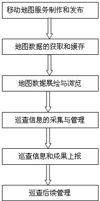
[0020] The realization steps of the inventive method are as follows:

[0021] 1. Production and release of map spatial information services

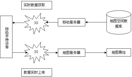
[0022] Browsing, operating, and even editing maps on mobile handheld devices are very different from users performing various map operations on PCs. The display screen of the mobile handheld device (including display resolution, buttons, and user interaction, etc.), memory and storage space limitations, and various external environmental conditions (light, rain, etc.) Maps have a certain impact. The present invention mainly proposes the design of the following aspects:

[0023] (1) Mobile map service design for industry applications

[0024] When designing and making a mobile map service, the first important factor to consider is the task in which the mobile map service is applied and the conditions of its users. These factors directly affect the browsing of layers in the map, Roaming, query and other operations.

[0025] Regardless...


PUM


Abstract

The invention discloses a geographic information system (GIS) spatial information technology-based method for mobile patrol and real state monitoring. The method comprises the following steps of: accessing a security service through a virtual private network (VPN) mode when a mobile handheld device logs on a system, and calling an identification service registered in a unified data service by the security service to identify the legality of user information and the device; and after successfully logging on the system, sending the user information and device information to a token service through the security service, and returning a token by the token service according to service authorities corresponding to the user information and the device information so that the device acquires a valid token and then can successfully access to a mobile map service and acquire map data. By using the method, the security of map spatial data and services can be guaranteed, and the map data can be prevented from leaking and stealing.

Description

technical field [0001] The invention relates to a mobile inspection method based on GIS (Geographic Information System) spatial information technology, which applies various GIS spatial information to various mobile handheld devices to meet the mobile inspection requirements of industries such as land resources, urban management, water conservancy, and underground pipelines. The mobile GIS method required by the inspection can realize the real-time and dynamic collection and transmission of information conveniently and efficiently, as well as the online monitoring of the inspection process and results. Background technique [0002] The mobile collection and integrated application technology of spatial information is a frontier hotspot and difficulty in GIS research. Mobile GIS includes a combination of a series of technologies, such as GIS, mobile hardware devices (including smart phones, PDA and other portable devices and personal computers, etc.), positioning systems (GPS ...

Claims


Application Information

Patent Timeline
IPC IPC(8): G07C1/20G09B29/00
Inventor 孙在宏吴长彬吉波沈健
Owner NANJING GUOTU INFORMATION IND
Why Eureka
Try Eureka