Fault recognition method for multi-constellation integrated navigation system

An integrated navigation system and fault identification technology, which is applied to satellite radio beacon positioning systems, radio wave measurement systems, measurement devices, etc. increase, etc.

Active Publication Date: 2011-07-27
CHINA AEROSPACE KEGONG INFORMATION TECH RES INST
View PDF7 Cites 14 Cited by
  • Summary
  • Abstract
  • Description
  • Claims
  • Application Information

AI Technical Summary

Problems solved by technology

[0004] 1) The positioning accuracy of satellite navigation is affected by the number of satellites and their geometric distribution. The performance of the GPS system will deteriorate in areas where there are not many satellites and the positioning geometric distribution is not good;
[0005] 2) The satellite navigation system is huge and complex, and software and hardware failures of the system will also increase the positioning error of satellite navigation, which will affect the flight safety of the aircraft;
[0006] 3) The owning country of the GPS system has taken some measures to limit the positioning accuracy for its own national security interests. In the case of military conflicts and wars in the future, it is difficult to guarantee that the owning country will not adopt similar measures for military interests;
[0007] 4) Electromagnetic waves in the external environment, changes in the ionosphere, natural interference, man-made interference, especially hostile interference will also affect the reliability of satellite navigation
[0009] The invention patent application with the application number CN 200610165465.8 discloses a GNSS receiver autonomous integrity monitoring method based on multi-satellite fault identification, which has the following steps: a. Carry out availability analysis of autonomous integrity; b. Star fault judgme

Method used


Image

  • Fault recognition method for multi-constellation integrated navigation system
  • Fault recognition method for multi-constellation integrated navigation system
  • Fault recognition method for multi-constellation integrated navigation system

Examples


Example Embodiment

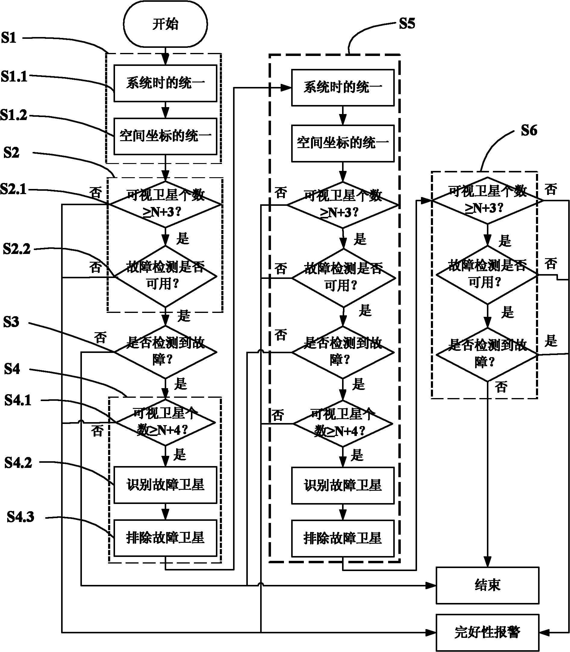
[0065] figure 1 It is the overall flow chart of the fault identification method of a multi-constellation integrated navigation system of the present invention

[0066] Such as figure 1 As shown, the method includes the following steps:

[0067] Step S1, unify the time and space coordinates of the multi-constellation system. For the observation data from multiple different constellations, it is necessary to unify the time and space coordinates of the multi-constellation system first to ensure the accuracy of the system's data calculation and at the same time ensure The success rate of identifying and troubleshooting satellites is improved. This step is completed by the following two sub-steps:

[0068] Sub-step S1.1, unify the multi-constellation system time. According to the fixed conversion relationship between the system time of each constellation and UTC, the system time of different constellations is roughly calculated to unify the system time of all constellation systems ....


PUM


Abstract

The invention discloses a fault recognition method for a multi-constellation integrated navigation system. The method comprises the following steps of: unifying time and space coordinates of the multi-constellation system; determining fault detection usability; determining a fault; recognizing and removing faulty satellites and the like. Faults of various satellites can be monitored and recognized simultaneously, the success rate of recognizing and removing the faulty satellites is greatly improved due to unification of the time and space coordinates of the multi-constellation system and repeated detection and judgment, and the navigation positioning accuracy, positioning performance and reliability of the multi-constellation integrated navigation system are improved; therefore, the navigation service performance is improved.

Description

Technical field [0001] The invention relates to a fault identification method of a navigation system, in particular to a fault identification method of a multi-constellation integrated navigation system. Background technique [0002] The GPS system (Global Satellite Navigation System) has been widely used in the world. In the GPS system, the multi-constellation integrated navigation system has high navigation positioning accuracy and good positioning performance and reliability, which makes it provide navigation services It can reach the level that can only be achieved by using the enhanced system. [0003] However, when the multi-constellation integrated navigation system has faulty satellites or long-term false locks, etc., when the system error exceeds the allowable limit, it will not be competent for navigation. At present, the main reasons for the positioning failure of the satellite navigation system are as follows: [0004] 1) The positioning accuracy of satellite navigation...

Claims


Application Information

Patent Timeline
IPC IPC(8): G01S19/20
Inventor 陆伟宁王千喜翟羽佳杨晓昆胡强李秋凤刘岩
Owner CHINA AEROSPACE KEGONG INFORMATION TECH RES INST
Why Eureka
Try Eureka