Forest city planning

An urban planning and forestry technology, applied in special buildings, roads, public buildings, etc., can solve the problem of neglecting the coordinated development of cities and surrounding towns

Inactive Publication Date: 2011-08-03
李红彬
View PDF0 Cites 4 Cited by
  • Summary
  • Abstract
  • Description
  • Claims
  • Application Information

AI Technical Summary

Problems solved by technology

[0006] Some planning departments stick to the old framework of "urban planning" and ignore the coordinated development of the city and surrounding towns. The planning department and the land management department adopt a divide-and-conquer approach, making the urban-suburban junction a dirty and chaotic area of ​​"no matter what". , causing the eye-catching "suburban disease"

Method used


Image

  • Forest city planning

Examples


Embodiment Construction

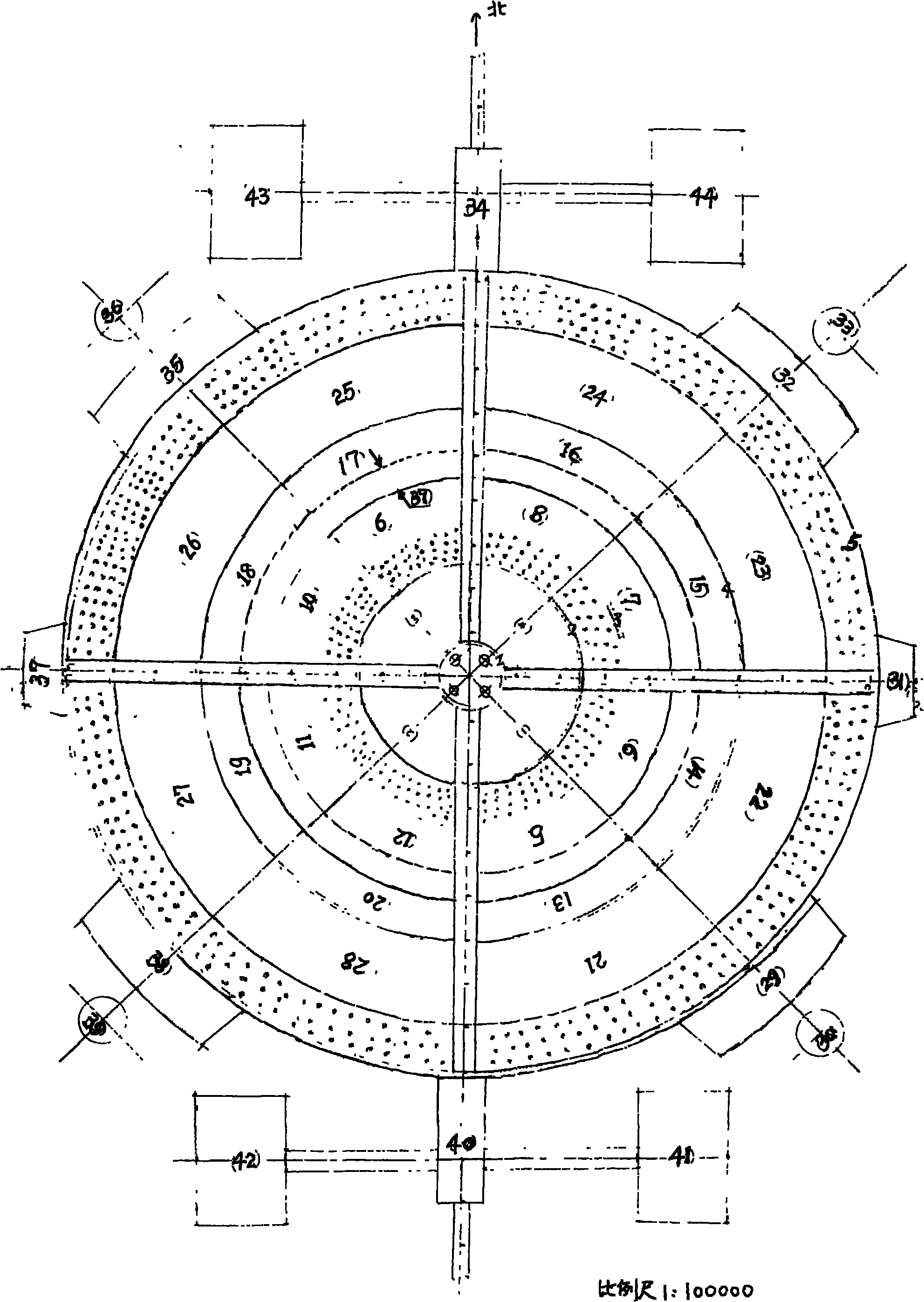
[0027] see figure 1, based on the bottom edge of 210mm of A4 paper (210×300mm), use a straightedge (250mm) to move upward in parallel to 150mm, draw a straight line 200mm long along the straightedge, and draw a vertical line 250mm long through the midpoint. Use the intersection point of two straight lines as the origin, the vertical line as the ordinate—indicates the north-south direction, the horizontal line as the abscissa—indicates the east-west direction, and the two number axes are perpendicular to each other to establish the engineering coordinate system. Use the horizontal line of the protractor to coincide with the horizontal axis, fit the 90° straight line to the upper half of the vertical axis, take a point at 45° west by north and 45° east by north of the coordinate axis, and connect the line with the origin and its extension The line is the bisector of the angle between the axes. Use a compass to measure 5mm, take the origin as a fixed point, and take a point on t...


PUM


Abstract

The invention relates to a city planning, i.e. the entire allocation of a city. The entire allocation of the city comprises the following steps of: planning functional regions, wherein each functional block comprises a center region, a commercial region, a university region, an administrative region, a financial region, a media region, and the like of the city; matching with magnetic suspension type light rail vehicles running around the functional regions, wherein a commercial building, a high and new technical area, a wholesale mall, a coach station, a railway station and an industrial area are positioned around the periphery of a city proper, and forest belts penetrate through middles. The invention aims at enabling the city to be developed towards a better direction by decreasing urban vehicles, reducing urban architecture, decreasing urban shops, increasing urban green resources and citizen incomes, keeping ecological balance and enhancing the bearing capacity of the city on the society; and in addition, the city planning is a part of regional planning and an essential condition for developing an innovative country.

Description

technical field [0001] The invention relates to the three-dimensional planning of cities and belongs to the technical field of international patent classification E04H. Background technique [0002] Cities in China are divided into municipalities directly under the Central Government, cities under separate state planning, central cities (provincial capitals), and prefecture-level cities according to their geographical location and administrative level. County-level cities, etc., this article takes the central city as an example. [0003] For example: Zhengzhou City, the capital of Henan Province in China, is the political, economic and cultural center of the whole province. It now governs 5 cities, 1 county and 6 districts. The total area is 7446.2 square kilometers, the urban area is 1010.3 square kilometers, the central built-up area is 137.5 square kilometers, the city's population is 6.77 million, and the downtown area is 2.3399 million. Zhengzhou is an emerging indus...

Claims


Application Information

Patent Timeline
Patent Type & Authority Applications(China)
IPC IPC(8): E04H3/00E04H1/00E01C1/00
Inventor 李红彬
Owner 李红彬
Why Eureka
Try Eureka