Parameter monitor of base station antenna and automatic monitoring method

An automatic monitoring and base station antenna technology, applied in transmission monitoring, transmitter monitoring, electrical components, etc., can solve the problems of lagging test results, inability to accurately meet design requirements, inaccurate GPS latitude and longitude coordinates, etc., and solve manual monitoring Error and instability, reduce maintenance optimization cost, save manpower and material resources

Inactive Publication Date: 2011-08-31
李英祥
View PDF4 Cites 50 Cited by
  • Summary
  • Abstract
  • Description
  • Claims
  • Application Information

AI Technical Summary

Problems solved by technology

Due to differences in the skill and experience of engineering personnel, incorrect or unstable monitoring results are produced, and the design requirements cannot be accurately met
[0011] 2. In order to obtain the orientation information of the base station antenna, engineers and technicians must directly climb on the base station antenna installed on the multi-storey building or iron tower, and manually use the compass to monitor the manual readings. Due to the magnetic interference near the iron tower, the monitoring near the iron tower will cause large errors
Due to the randomness of the reference surface, the reference points for possible monitoring this time and last time are different, and the monitoring accuracy is difficult to meet the design requirements
[0013] 4. In order to obtain the latitude and longitude information of the base station antenna, engineers and technicians must hold a high-precision GPS handheld and monitor it at the tower position for a period of time. The accuracy is limited by the internal accuracy of the selected GPS receiver module, and the price of high-precision handheld GPS Expensive and inseparable from human participation
However, the drive test equipment is generally in motion (usually installed on the car), the GPS latitude and longit

Method used


Image

  • Parameter monitor of base station antenna and automatic monitoring method
  • Parameter monitor of base station antenna and automatic monitoring method
  • Parameter monitor of base station antenna and automatic monitoring method

Examples


Embodiment Construction

[0037] The present invention will be described in detail below in conjunction with the accompanying drawings and embodiments.

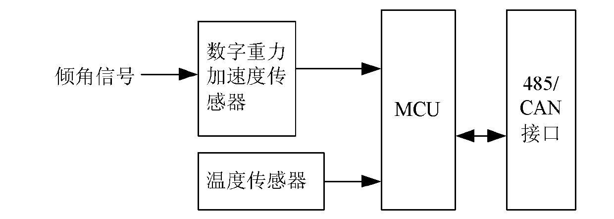
[0038] "Sensor is a pre-component in the monitoring system, and its input variable is converted into a signal that can be monitored." Depending on the output, there are analog sensors and digital sensors.

[0039] 1. Technical solution for downtilt monitoring

[0040] (1) Working principle of digital gravity acceleration sensor

[0041] The digital acceleration of gravity sensor is a sensor used to convert the physical signal of acceleration of gravity into a digital electrical signal that is easy to monitor. The inclination sensor uses the gravitational acceleration sensor to monitor and process the acceleration component. When the sensor is stationary, that is, when there is no horizontal or vertical acceleration, the angle between the gravitational acceleration direction and the sensitive axis of the sensor is the inclination angle. When the sen...


PUM


Abstract

The invention discloses a parameter monitor of a base station antenna and an automatic monitoring method. A digital gravity acceleration sensor is used for measuring an antenna downtilt accurately on the basis of gravity acceleration; an angular displacement sensor is used for measuring an antenna azimuth on the basis of the relationship between the linear characteristic of a resistor in the angular displacement sensor and a divider resistor; a GPS (Global Position System) carrier phase sensor is used for accurately measuring the suspension height and longitude and latitude coordinates of an antenna by a carrier phase difference algorithm; an RMS (Root Mean Square) voltage sensor is used for monitoring antenna signal transmitting power through RMS voltage; GPRS (General Packet Radio Service) / CDMA (Code Division Multiple Access) / 3G (the Third Generation) or Ethernet is used for automatically transmitting measured data to a network management center in the form of an IP (Internet Protocol) package. By the invention, the problems of low accuracy, large manual measuring error and unstable measured result in installation and adjustment of a base station antenna in a traditional way can be solved; the problem that the changes of the azimuth angle, the downtilt and the radiation power of an antenna cannot be detected in time can be solved, the problem of remote automatic control of electric tilted antenna based on AISG (Antenna Interface Standards Group) can be solved, and the problem that the antenna information is time and labor consuming to obtain can be solved.

Description

technical field [0001] The present invention relates to the field of wireless communication Background technique [0002] The communication base station antenna azimuth, antenna downtilt, antenna height and precise latitude and longitude coordinates, antenna signal strength and the performance parameters of the antenna itself determine the coverage of the base station, and as the main engineering parameters of the antenna (antenna azimuth, antenna downtilt, Antenna height and precise latitude and longitude coordinates, antenna signal strength) are important parameters for wireless network planning. Antenna azimuth, antenna downtilt, antenna height, precise latitude and longitude coordinates, and antenna signal strength are important factors that affect the communication quality of mobile users. Accurate monitoring of the antenna azimuth, antenna downtilt, antenna height, precise latitude and longitude coordinates, antenna signal strength and whether it changes is particular...

Claims


Application Information

Patent Timeline
IPC IPC(8): H04B17/00H04B17/12
Inventor 李英祥
Owner 李英祥
Why Eureka
Try Eureka