Error correction method of autonomous navigation system

An autonomous navigation system and error correction technology, applied in the direction of measuring devices, instruments, etc., to achieve the effect of improving navigation accuracy

Active Publication Date: 2011-09-07
BEIJING INST OF CONTROL ENG
View PDF3 Cites 26 Cited by
  • Summary
  • Abstract
  • Description
  • Claims
  • Application Information

AI Technical Summary

Problems solved by technology

[0004] The technical solution problem of the present invention is: to overcome the deficiencies in the prior art, propose an autonomous navigation system error correction method, which can solve the problem of excessive navigation error caused by sensor installation error, and improve the navigation of the system by online estimation of installation deviation precision

Method used


Image

  • Error correction method of autonomous navigation system
  • Error correction method of autonomous navigation system
  • Error correction method of autonomous navigation system

Examples


Embodiment

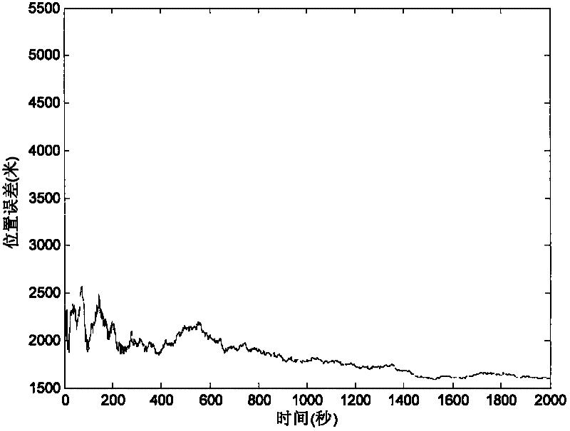
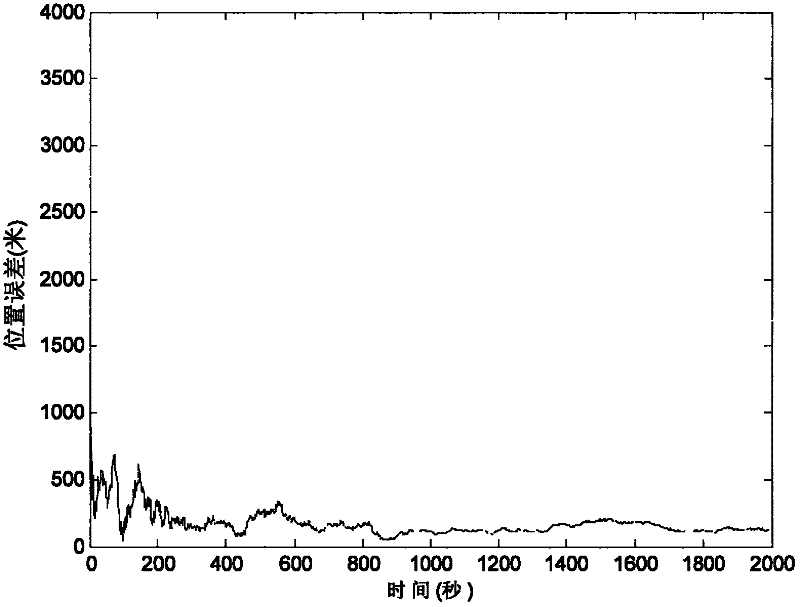
[0035] In order to show the advantages of this method more clearly, a mathematical simulation is carried out here. The simulation conditions are: the satellite altitude is 500 kilometers, the inclination angle is 97.4 degrees, and the measurement error of the earth center direction is 0.02 degrees. It is assumed that the installation error angles of the ultraviolet sensor along the three coordinate axes are respectively 50", 40", 30".

[0036] figure 1 is the simulation result without correcting the installation error, figure 2 It is a diagram of the simulation result after the installation error is corrected by the method of the present invention. It can be seen from the figure that the position accuracy is 1620.059 meters when the system error is not corrected, and the position accuracy is 125.525 meters after the system error is corrected. Therefore, after using the method of the present invention to estimate and correct the installation error angle, the navigation accura...


PUM


Abstract

The invention discloses an error correction method of an autonomous navigation system. In the autonomous navigation system based on an ultraviolet earth sensor and a star sensor, the ultraviolet earth sensor is used for measuring a geocentric vector in a satellite local system, and the star sensor is used for measuring an attitude transformation matrix of the satellite local system. Since the sensors inevitably have relative installation error, and a filter cannot eliminate the system error, the navigation accuracy becomes poor. In the method provided by the invention, the relative installation error of the ultraviolet earth sensor and the star sensor is modeled, and the installation error is expanded into a state variable so as to perform navigation filtering. Assuming that the satellite can obtain high-accuracy position measurement information by a GPS receiver or ground orbit determination within certain period of time, the system error can be estimated and corrected in time by filtering. The method provided by the invention has simple operation and can obviously improve the navigation accuracy.

Description

technical field [0001] The invention belongs to the field of spacecraft autonomous navigation, and relates to an error correction method for a spacecraft navigation system. Background technique [0002] Satellite autonomous navigation using imaging earth sensors and star sensors is a typical astronomical navigation method. The accuracy of autonomous navigation is affected by various factors such as sensor measurement accuracy, model accuracy describing the relevant characteristics of the measured target, and navigation algorithms. . Compared with random errors, systematic errors of navigation sensors (such as measurement deviations, installation errors, model errors, etc.) have a much greater impact on navigation accuracy. This is because the navigation filter can suppress the measurement noise, but it is powerless to some constant or regular measurement errors. Therefore, the on-orbit calibration and compensation of system errors such as constant measurement deviation and...

Claims


Application Information

Patent Timeline
Patent Type & Authority Applications(China)
IPC IPC(8): G01C25/00
Inventor 魏春岭张斌黄翔宇王大轶
Owner BEIJING INST OF CONTROL ENG
Why Eureka
Try Eureka