Natural-landmark-based unmanned helicopter visual speed measurement method

An unmanned helicopter, a natural technology, applied in the direction of the device using the optical method, can solve the problems that the pitot tube is easily disturbed by the wind speed, the pitot tube measurement cannot be measured accurately, etc., and achieve a simple structure and high reliability Effect

Inactive Publication Date: 2011-09-07
TSINGHUA UNIV
View PDF4 Cites 21 Cited by
  • Summary
  • Abstract
  • Description
  • Claims
  • Application Information

AI Technical Summary

Problems solved by technology

Due to the complex flow field around the helicopter, the pitot measurement is easily disturbed by the rotor wake and cannot be measured accurately
In addition, the measured value of the pitot tube is also easily disturbed by the wind speed

Method used


Image

  • Natural-landmark-based unmanned helicopter visual speed measurement method
  • Natural-landmark-based unmanned helicopter visual speed measurement method
  • Natural-landmark-based unmanned helicopter visual speed measurement method

Examples


Embodiment Construction

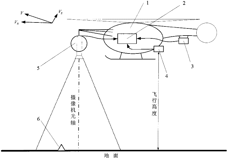
[0030] The autonomous landing method of an unmanned helicopter based on natural landmarks is mainly composed of an unmanned helicopter (1), a flight control computer (2), a magnetic heading sensor (3), an altimeter (4) and an onboard camera (5).

[0031] During the flight of the unmanned helicopter (1), the flight control computer (2) obtains the flight direction of the unmanned helicopter through the magnetic heading sensor (3); the flight control computer (2) obtains the flight direction of the unmanned helicopter through the altimeter (4). (1) Height H from the ground;

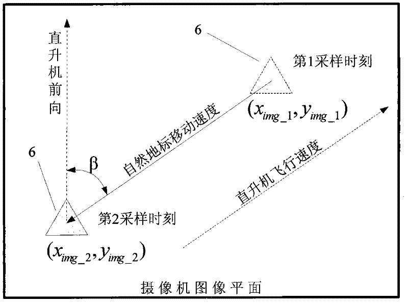
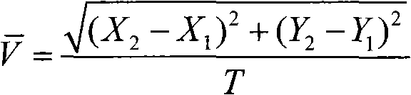
[0032] Simultaneously, the on-board camera (5) continuously takes images of the ground, and transmits the images to the flight control computer (2) in real time. The flight control computer (2) can calculate the relative distance of the unmanned helicopter (1) by calculating the moving pixels of the ground natural landmarks (6) in the image captured by the airborne camera (5) within two adjacent sampling ti...


PUM


Abstract

The invention discloses a natural-landmark-based unmanned helicopter visual speed measurement method, which belongs to the technical field of unmanned aerial vehicles. The method is characterized in that: the method is implemented by an unmanned helicopter, a flight control computer, a magnetic course sensor, a height gauge and an airborne video camera, and comprises that: in the flight process of the unmanned helicopter, the flight control computer obtains the height of the unmanned helicopter from the ground by the height gauge; the flight control computer calculates the horizontal flight rate of the unmanned helicopter relative to the ground by detecting the motion rate of a natural landmark on the ground in an image of the video image; and the flight control computer obtains a course angle of the unmanned helicopter by the magnetic course sensor, and calculates the horizontal flight speed of the unmanned helicopter. The method is free from the influence of global positioning system (GPS) signals and wind speed, and is particularly applied to the accurate speed measurement of the unmanned helicopter in a low-altitude complex environment suck as an inter-building environment, a grove environment even an indoor environment without increasing the takeoff weight of the unmanned helicopter.

Description

technical field [0001] The invention is a method for measuring the flight speed of an unmanned helicopter relative to the ground, and can use the onboard camera, magnetic heading sensor and altimeter usually provided by the unmanned helicopter to calculate the flight speed of the unmanned helicopter through an image recognition method. It is mainly used in technical fields such as aerospace, drones and robots. Background technique [0002] The flight speed of an unmanned helicopter is a key flight parameter. In the past, there are usually two methods of flight speed measurement: GPS speed measurement and pitot speed measurement. [0003] The GPS speed measurement method obtains the flight speed of the unmanned helicopter relative to the ground by calculating the GPS displacement of the unmanned helicopter in two adjacent sampling times. Because the GPS signal is easily blocked by buildings and trees. Therefore, this method has a better measurement effect in high-altitude ...

Claims


Application Information

Patent Timeline
Patent Type & Authority Applications(China)
IPC IPC(8): G01P3/38
Inventor 王冠林朱纪洪
Owner TSINGHUA UNIV
Why Eureka
Try Eureka