Optimization design method for aerial survey parameter of airborne laser radar

An airborne laser radar, optimized design technology, applied in the field of aerial remote sensing and earth observation, can solve the problem of lack of mature flight operation software, and achieve the effect of broad application prospects

Inactive Publication Date: 2011-09-07
BEIHANG UNIV
View PDF3 Cites 16 Cited by
  • Summary
  • Abstract
  • Description
  • Claims
  • Application Information

AI Technical Summary

Problems solved by technology

As for airborne LiDAR, since the development of domestic LiDAR hardware has just started, there is no mature flight operation software.

Method used


Image

  • Optimization design method for aerial survey parameter of airborne laser radar
  • Optimization design method for aerial survey parameter of airborne laser radar
  • Optimization design method for aerial survey parameter of airborne laser radar

Examples


Embodiment Construction

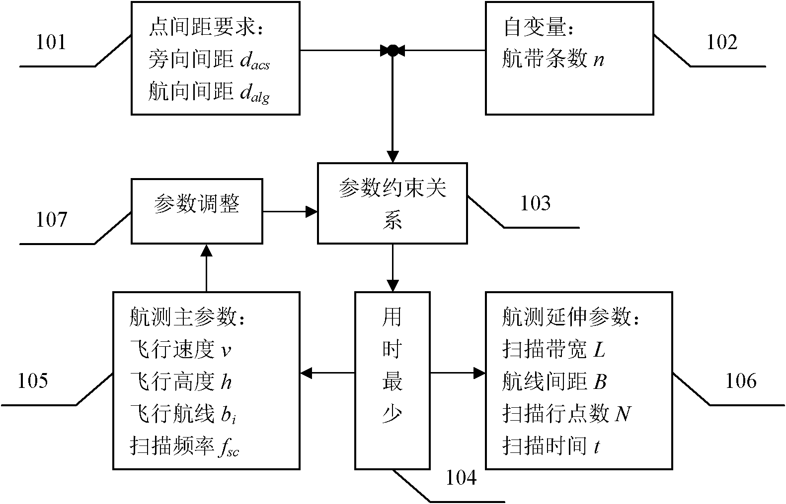
[0020] The specific implementation manners of the present invention will be described in detail below in conjunction with the accompanying drawings. The optimization design process of aerial survey parameters is as follows: figure 1 As shown, the precondition of satisfying the laser footpoint distribution 101, the number of scanning strips 102 as the independent variable, the minimum time for 104 pairs of scanning areas to complete the scan is the optimization purpose, and the mapping relationship between each parameter and the laser footpoint distribution is constrained The condition 103 is to obtain the best aerial survey parameter value, and then adjust the parameter 107 according to the actual situation. The aerial survey parameters include aerial survey main parameters 105 and aerial survey extended parameters 106. The aerial survey main parameters include flight altitude, flight speed, flight path position and scanning frequency, etc. The aerial survey extended parameter...


PUM


Abstract

The invention discloses an optimization design method for aerial survey parameter of an airborne laser radar. Taking the number of scanning aerial strips as an independent variable and the least scanning time as the target, the method can determine the optimal aerial survey parameter by using the mapping relationship of laser parameters, flight parameters, scanning system parameters and laser foot-point distribution as a constraint condition and meeting the requirements of the aerial survey operation for the laser foot-point distribution density and the actual range of each parameter.

Description

technical field [0001] The invention relates to the fields of aerial remote sensing and earth observation, and mainly relates to a method for realizing the optimal design of airborne laser radar aerial survey parameters. Background technique [0002] Airborne lidar (Li DAR) is a new active means of earth observation, which can efficiently and accurately measure terrain information, thereby obtaining high-resolution geospatial information, so it is widely used in terrain mapping, ocean bathymetry, 3D City modeling, military defense and other fields. However, airborne lidar is a high-cost aerial survey method that integrates a flight platform and a laser measurement system. For civilian use, only a few companies in China currently have airborne lidar aerial survey systems, and their rental costs are relatively high. Therefore, in the case of meeting the requirements of aerial survey, it is imperative to quickly complete the aerial survey task, whether it is to reduce user cos...

Claims


Application Information

Patent Timeline
Patent Type & Authority Applications(China)
IPC IPC(8): G01S7/48G01S17/00
Inventor 徐立军田祥瑞李小路王建军
Owner BEIHANG UNIV
Why Eureka
Try Eureka