Highway safe driving system

A highway and safety technology, applied in the field of systems to increase vehicle driving safety, can solve the problems of insufficient positioning and speed accuracy, long distances, and inability to notify the distance and direction of vehicles, and achieve the effect of reducing initial investment and low cost.

Inactive Publication Date: 2011-09-21
邢刚
View PDF5 Cites 25 Cited by
  • Summary
  • Abstract
  • Description
  • Claims
  • Application Information

AI Technical Summary

Problems solved by technology

[0009] Through the search of China Patent Information Center and other relevant websites, it is found that there are also vehicle "rescue" and "navigation" systems that combine GPS and GPRS, but the positioning and speed accuracy is insufficient, and the driving safety of the expressway cannot be enhanced. The invention is far from
There is only one patent "Comprehensive Monitoring Device for Highway Based on Integrated Navigation", which is somewhat similar, but it does not use differential correction technology, and the accuracy is insufficient (the position error of civilian GPS is 15 meters, so the estimated speed error can exceed 40Km/h). Because of the overspeed warning, it is obviously not practical; in addition, the patent cannot determine which lane the vehicle is in, and

Method used


Image

  • Highway safe driving system
  • Highway safe driving system
  • Highway safe driving system

Examples


Embodiment Construction

[0058] The present invention will be further described below in conjunction with drawings and embodiments.

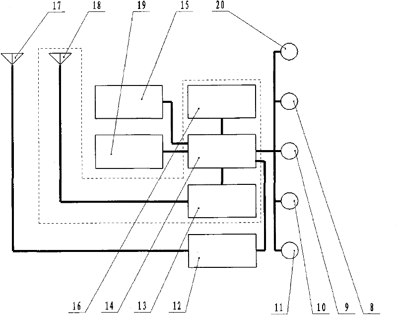
[0059] 5.1 Structure

[0060] 5.1.1 Base station

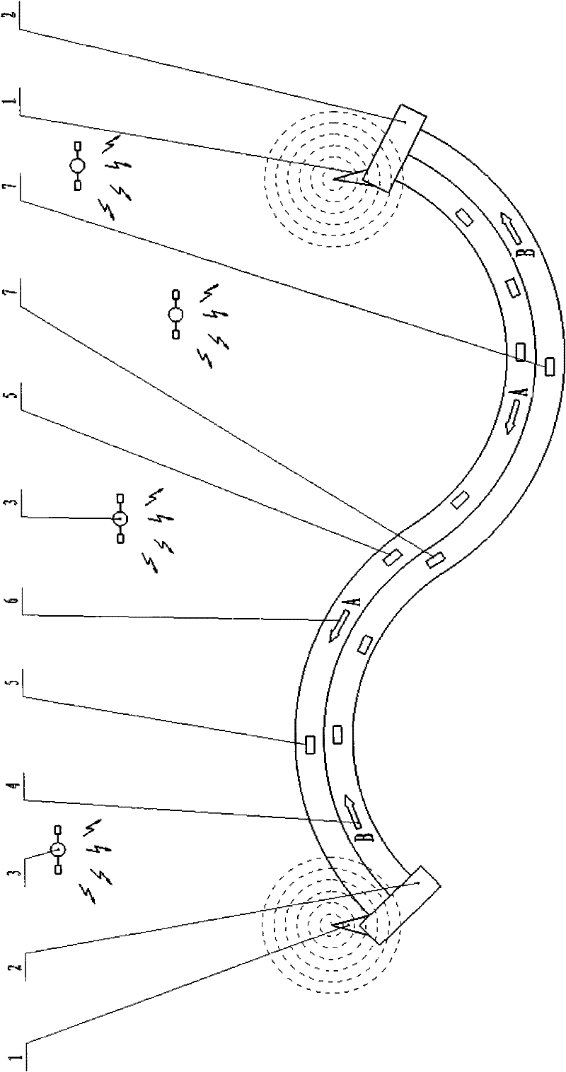
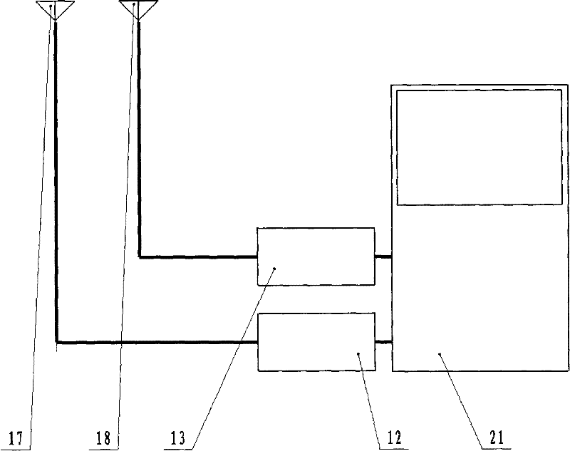
[0061] A special reference station (1) for this highway is respectively built at the two ports of each expressway, that is, toll stations. Each reference station (1) is equipped with a GPRS antenna (17) and a GPS satellite communication antenna (18). The antennas (17, 18) are respectively connected to the system host (20) through the GPRS module (12) and the satellite communication module (13). The host computers (20) of the two reference stations (1) are equal in status in the system. In addition to the purchased general GPS and GPRS software, they are also equipped with unique software that can connect GPS and GPRS to establish and run GIS. The special system software on this expressway forms a wide area network with the dedicated GPS.

[0062] 5.1.2 Vehicle GPS for Highways

[0063] See figure 2 . In the dott...


PUM


Abstract

The invention relates to a system for enhancing vehicle driving safety on a highway. In the system, a GPS (Global Positioning System), a GPRS (General Packet Radio Service) system, a GIS (Geographic Information System) and other technologies are comprehensively utilized, the position and the speed of each vehicle on the whole highway can be precisely measured in real time, each vehicle can be made to learn the information of the vehicle per se and the information of surrounding relevant vehicles in real time, and proper measures can be taken when in necessity. The system is beneficial to not only great reduction of highway accidents but also great increase of highway trafficability in a severe weather.

Description

1 Technical field [0001] The present invention relates to a system for increasing driving safety of automobiles on expressways, which comprehensively uses GPS (Global Positioning System), GPRS (General Packet Radio Service) system and GIS (Geographic Information System) and other technical means. 2 background technology [0002] At present, the expressway management department basically does not grasp or manage the driving conditions on the road, but simply manages them in foggy and snowy days-release at limited time intervals or simply close the entire expressway. This can not help greatly affecting traffic, and the concentration of fog is constantly changing with time and place. Vehicles released when the visibility at the entrance is still good, often encounter dense fog on the way, often causing serious accidents such as serial rear-end collisions. [0003] At present, the "anti-collision radar" installed in some cars either uses ultrasonic waves, which have a very shor...

Claims


Application Information

Patent Timeline
IPC IPC(8): G08G1/16G08G1/0962G08G1/0965
Inventor 邢刚王永瑞黄学战
Owner 邢刚
Why Eureka
Try Eureka