GPS (Global Positioning System)-based inter-satellite baseline measurement method for flight of formed array around satellite

A measurement method and GPS antenna technology, applied in the field of satellite-to-satellite baseline measurement, to achieve the effect of ensuring reliability, reducing the impact of bit error rate, and continuous and reliable inter-satellite communication

Active Publication Date: 2013-06-19
AEROSPACE DONGFANGHONG SATELLITE
View PDF1 Cites 1 Cited by
  • Summary
  • Abstract
  • Description
  • Claims
  • Application Information

AI Technical Summary

Problems solved by technology

[0004] The problem solved by the technology of the present invention is: to overcome the deficiencies of the prior art, to provide a GPS-based high-precision baseline measurement method between satellites during the small-scale formation flying around, and to solve the problems before the formation flight, during the formation flight, and after the formation flight high-precision inter-satellite measurement problems, and provide necessary information for formation satellites to achieve autonomous control and maintain a stable configuration through these high-precision measurement data

Method used


Image

  • GPS (Global Positioning System)-based inter-satellite baseline measurement method for flight of formed array around satellite
  • GPS (Global Positioning System)-based inter-satellite baseline measurement method for flight of formed array around satellite
  • GPS (Global Positioning System)-based inter-satellite baseline measurement method for flight of formed array around satellite

Examples


Embodiment Construction

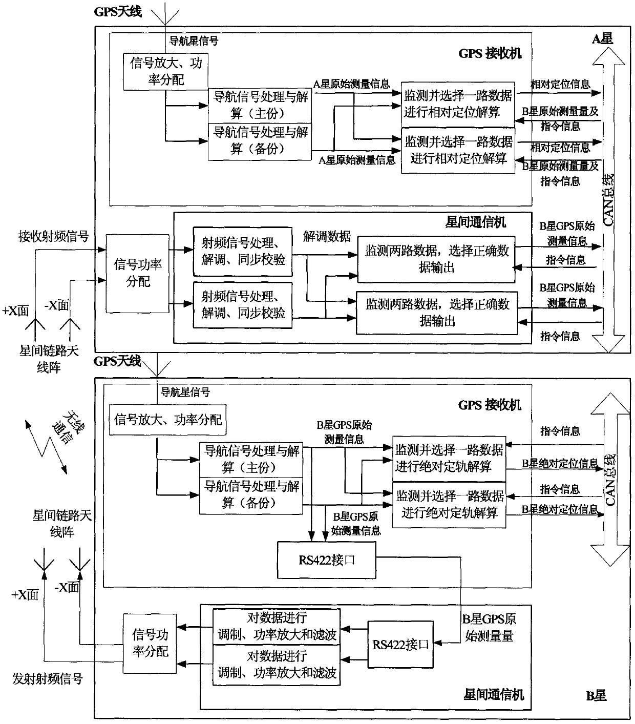
[0023] Such as figure 1 Shown is the schematic diagram of the method of the present invention. Assuming that the two satellites participating in the baseline measurement are A star and B star, the GPS receiving antenna, GPS receiver, inter-satellite communicator, and inter-satellite communication antenna array should be configured on the two satellites respectively. Before the inter-satellite baseline measurement, the GPS receivers on the two satellites both receive the GPS navigation star signal, respectively perform absolute positioning calculations, and collect raw measurement information in real time. The GPS receiver on the B star transmits the collected original measurement information to the inter-satellite communication machine of the B star through the RS-422 interface, and the inter-satellite communication machine modulates and radiates the original measurement information to space through the inter-satellite communication antenna array . When the distance between ...


PUM


Abstract

The invention provides a GPS (Global Positioning System)-based inter-satellite baseline measurement method for flight of a formed array around a satellite. GPS receivers of two satellites (a satellite A and a satellite B) are used for receiving navigation satellite signals and respectively calculating to obtain positioning information. An inter-satellite communication device and an inter-satellite communication antenna array between the two satellites form an inter-satellite communication link for one-way communication, and the two satellites are respectively provided with an isospinning antenna array on the plus X-plane and the minus X-plane. The inter-satellite communication device of the satellite B is used for receiving GPS positioning information of the satellite B through an RS422 interface and modulating and amplifying the GPS positioning information of the satellite B into radio-frequency signals, and the radio-frequency signals are radiated to the whole space through the inter-satellite communication antenna. The inter-satellite communication device of the satellite A is used for receiving signals transmitted by the satellite B, demodulating to restore the original GPS measurement information of the satellite B, and transmitting the information to the GPS receiver of the satellite A through a CAN (Controller Area Network) bus. Relative positioning calculation is carried out in the GPS receiver of the satellite A, results are broadcast through the CAN bus, and thus, one inter-satellite baseline measurement is completed.

Description

technical field [0001] The invention relates to a satellite inter-satellite baseline measurement method. Background technique [0002] Small-scale satellite formation orbiting means that two or more satellites that are relatively close to each other maintain a specific formation configuration based on a certain point, and then fly around the earth with the same orbital period. Links work together to complete specific payloads such as InSAR and other high-precision measurement tasks. The InSAR formation has strict requirements on the baseline range, and the scale of the formation configuration is small, which puts forward higher requirements on the measurement accuracy of the relative position between two stars. The line connecting the centroids of the two satellites constitutes the inter-satellite baseline, and the actual measurement is the distance between the phase centers of the GPS antennas of the two satellites, which needs to be converted to obtain the distance betwee...

Claims


Application Information

Patent Timeline
Patent Type & Authority Patents(China)
IPC IPC(8): G01S19/04G01S19/14
Inventor 张蕾臧荣春陆波赵志明刘一薇高晓艳杨小江李东俊刘晓荣
Owner AEROSPACE DONGFANGHONG SATELLITE
Why Eureka
Try Eureka