Method for generating digital orthophoto map (DOM) by urban low altitude unmanned aerial vehicle

A digital orthophoto and system generation technology, applied in the field of aerial image processing, can solve the problems of occlusion by ground objects, a large number of manual adjustments and repairs of splicing lines, and the influence of image information interpretation, and achieve the effect of low precision.

Active Publication Date: 2012-06-20
SPACE STAR TECH CO LTD
View PDF2 Cites 64 Cited by
  • Summary
  • Abstract
  • Description
  • Claims
  • Application Information

AI Technical Summary

Problems solved by technology

For example, in the case of many buildings in urban areas, the stitching line needs a lot of manual adjustment and repair
In addition, when performing digital image correction in urban areas, since artificial buildings have not undergone effective differential correction, there is a problem that bui

Method used


Image

  • Method for generating digital orthophoto map (DOM) by urban low altitude unmanned aerial vehicle
  • Method for generating digital orthophoto map (DOM) by urban low altitude unmanned aerial vehicle
  • Method for generating digital orthophoto map (DOM) by urban low altitude unmanned aerial vehicle

Examples


Embodiment Construction

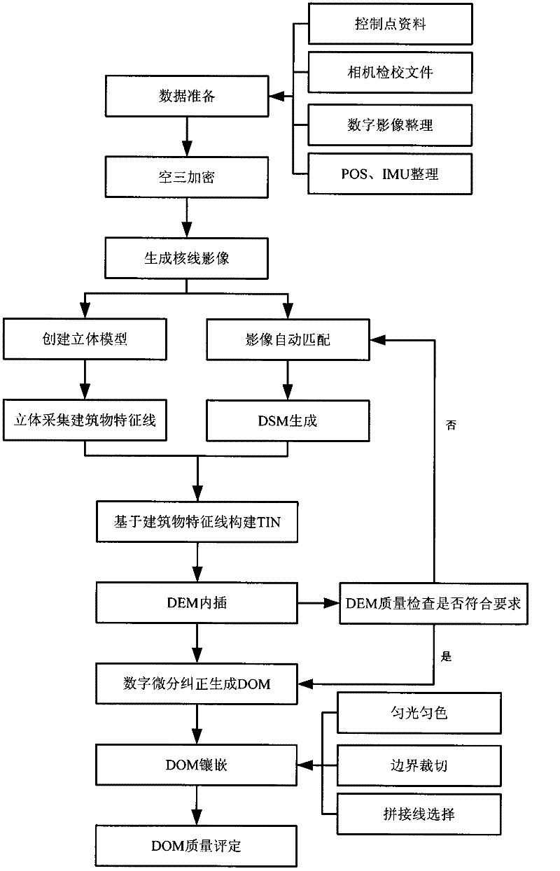
[0021] (1) Data preparation

[0022] The data involved in the urban low-altitude UAV system includes: control point data, camera calibration files, acquired digital images, and POS and IMU data corresponding to the digital images. The validity of these data needs to be checked.

[0023] (2) Air three encryption

[0024] Air three encryption calculates the internal and external orientation elements of each photo based on the control point data, digital images, and POS and IMU (ie attitude data) data corresponding to the digital images.

[0025] (3) Generate epipolar images

[0026] According to the aerial three encryption results, real-time epipolar image calculation and epipolar image resampling are performed to generate epipolar images.

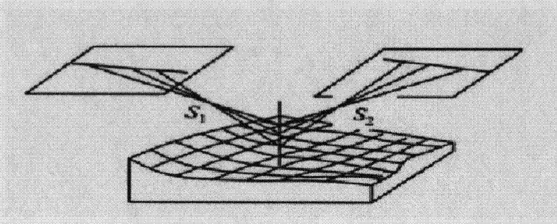
[0027] (4) Create a three-dimensional model

[0028] Establish a stereo observation and measurement environment, and create a stereo model of a stereo pair based on the generated epipolar images.

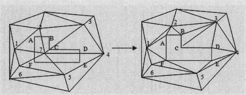
[0029] (5) Three-dimensional collection of building cha...


PUM


Abstract

A method for generating a digital orthophoto map (DOM) by an urban low altitude unmanned aerial vehicle comprises preparing control point data, cameral calibration correction files, and attitude data; performing aerotriangulation of image to generate an epipolar image; performing image matching to generate a digital surface model (DSM); constructing a triangular irregular network (TIN) based on urban building characteristics and performing digital elevation model (DEM) interpolation; performing digital differential rectification to generate a DOM; and performing urban low altitude DOM mosaicking which involves mosaic line selection, light and color homogenization and boundary cutting. The method of the invention can make full use of the high resolution advantage of urban low altitude image acquisition, and accurately generate DOM at high efficiency.

Description

Technical field [0001] The invention relates to a method for generating a digital orthophoto (DOM) by an urban low-altitude UAV system, which belongs to the technical field of aerial image processing and is applied to an urban low-altitude UAV system. Background technique [0002] Urban low-altitude unmanned aerial vehicle system, that is, using advanced unmanned aerial vehicle technology, sensor technology, telemetry technology, communication technology, GPS technology and remote sensing application technology, intelligent, professional, fast and low-cost access to urban land, planning, and environment The technical system that completes remote sensing information and completes remote sensing data processing and application analysis has the advantages of mobility, speed, efficiency, and economy. The images acquired by the urban low-altitude UAV system have the disadvantageous characteristics of small image size, large overlap, over-limit of the rotation angle of the photo, and i...

Claims


Application Information

Patent Timeline
IPC IPC(8): G01C11/00G01C11/04
Inventor 张峰郝胜勇解婓斐
Owner SPACE STAR TECH CO LTD
Why Eureka
Try Eureka