SINS (strap-down inertia navigation system)/SMANS (scene matching auxiliary navigation system)/TRNS (terrain reference navigation system) combined navigation method based on federated filtering and system

A technology of integrated navigation and federated filtering, applied in directions such as integrated navigators, can solve the problems of limited improved accuracy and high cost of inertial systems, and achieve the effects of improving accuracy, high fault tolerance, and correcting drift errors.

Active Publication Date: 2012-06-20
TSINGHUA UNIV
View PDF4 Cites 23 Cited by
  • Summary
  • Abstract
  • Description
  • Claims
  • Application Information

AI Technical Summary

Problems solved by technology

While accuracy can be improved by using more accurate sensors, the inertial syst...

Method used


Image

  • SINS (strap-down inertia navigation system)/SMANS (scene matching auxiliary navigation system)/TRNS (terrain reference navigation system) combined navigation method based on federated filtering and system
  • SINS (strap-down inertia navigation system)/SMANS (scene matching auxiliary navigation system)/TRNS (terrain reference navigation system) combined navigation method based on federated filtering and system
  • SINS (strap-down inertia navigation system)/SMANS (scene matching auxiliary navigation system)/TRNS (terrain reference navigation system) combined navigation method based on federated filtering and system

Examples


Embodiment 1

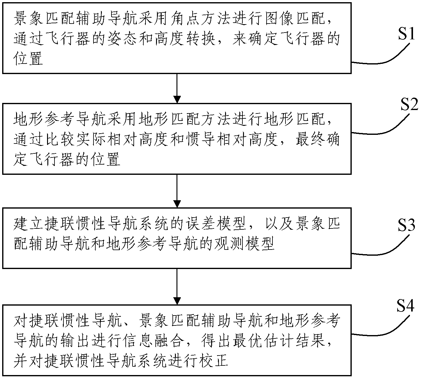
[0055] Such as figure 1 As shown, this embodiment records a SINS / SMANS / TRNS integrated navigation method based on federated filtering, which includes the following steps:

[0056] S1: Scene matching assisted navigation adopts corner point method for image matching, and determines the position of the aircraft through the conversion of the aircraft's attitude and altitude;

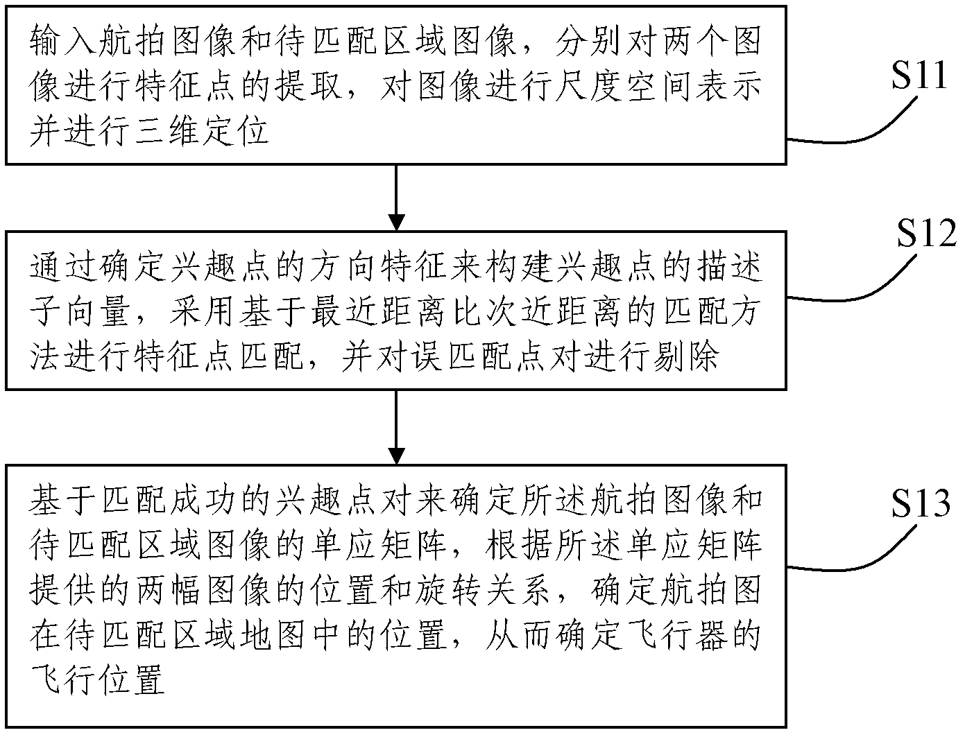
[0057] Such as figure 2 As shown, the step S1 specifically includes the following steps:

[0058] S11: Input the aerial image and the image of the area to be matched, and extract the feature points of the two images by using, for example, a method of approximating the Hessian matrix with a frame filter, and perform scale space representation and three-dimensional positioning of the image;

[0059] S12: Construct the descriptor vector of the interest point by determining the directional feature of the interest point, adopt the matching method based on the closest distance to the next closest distance to match the fea...

Embodiment 2

[0117] Such as Image 6 As shown, this embodiment records an integrated navigation system that implements the above integrated navigation method, including:

[0118] Atmospheric inertial navigation system, used to obtain and output inertial navigation position information;

[0119] The flight trajectory generator module is used to simulate the flight trajectory of the aircraft to obtain the position, speed and attitude information of the aircraft;

[0120] SINS / SMANS integrated navigation system, including:

[0121] An image sensor viewing zone and positioning parameter calculation module for calculating the viewing zone and positioning parameters of the image sensor on a computer based on the position information output by the atmospheric inertial navigation system;

[0122] The digital reference map database is used to obtain a suitable digital reference map according to the calculation result of the image sensor viewing area and the positioning parameter calculation module;

[0123] T...


PUM


Abstract

The invention discloses an SINS (strap-down inertia navigation system)/SMANS (scene matching auxiliary navigation system)/TRNS (terrain reference navigation system) combined navigation method based on federated filtering and a system. The method includes the following steps: performing image matching for scene matching auxiliary navigation, and confirming the position of an aircraft through the affine transformation relationship between a digital map and a shoot image; performing terrain matching for the terrain reference navigation through adopting the terrain matching method, and confirming the position of the aircraft as per the elevation data; building an error model for the SINS, as well as observation models of the SMANS and the TRNS; and performing information fusion for the output of the SINS, the SMANS and the TRNS, so as to obtain the optimum estimation result, and further calibrate the SINS; The system includes an atmosphere inertia navigation system, a flight path generator module, an SINS/SMANS combined navigation system, an SINS/TRNS combined navigation system and a federated filtering module. The method and the system can effectively improve the accuracy of the navigation systems, and have high fault tolerance, independency and reliability.

Description

Technical field [0001] The invention relates to the technical field of integrated navigation and positioning, in particular to a SINS / SMANS / TRNS integrated navigation method and system based on federated filtering. Background technique [0002] "Navigation" is to correctly guide the aircraft along the predetermined route to the destination within the specified time. In order to accomplish this task, it is necessary to know the instantaneous geographic location, sailing speed, and navigational attitude and heading of the aircraft at any time. These parameters are usually called navigation parameters. For manned aircraft, these navigation parameters can be obtained by the navigator by observing instruments and calculating. However, with the continuous increase of speed and range, the requirements for navigation are getting higher and higher; in order to reduce and replace the navigator's work, various navigation systems have appeared, which can automatically provide various navig...

Claims


Application Information

Patent Timeline
IPC IPC(8): G01C21/24
Inventor 程农胡海东李威杨霄
Owner TSINGHUA UNIV
Why Eureka
Try Eureka