Road state merging method based on floating car data (FCD) and earth magnetism detector

A fusion method and road state technology, applied in traffic flow detection, traffic control systems for road vehicles, instruments, etc., can solve problems such as inability to accurately obtain road state information, inability to provide decision-making information for travelers and traffic managers, and achieve The effect of improving accuracy

Active Publication Date: 2012-06-20
ANHUI KELI INFORMATION IND
View PDF5 Cites 26 Cited by
  • Summary
  • Abstract
  • Description
  • Claims
  • Application Information

AI Technical Summary

Problems solved by technology

[0005] FCD uses the speed calculation model to calculate the vehicle speed and average travel time of the road section passed by the current time, and can extract the road traffic status in real time. However, without

Method used


Image

  • Road state merging method based on floating car data (FCD) and earth magnetism detector
  • Road state merging method based on floating car data (FCD) and earth magnetism detector
  • Road state merging method based on floating car data (FCD) and earth magnetism detector

Examples


Embodiment Construction

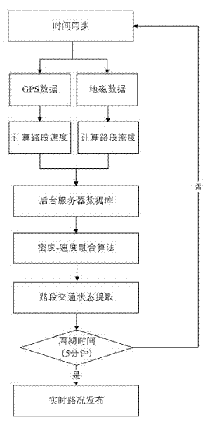
[0021] A road state fusion method based on FCD and geomagnetic detectors, the method includes the following sequential steps: (1) Use the floating car to detect the floating point data of each road section of the road network, obtain the speed information of each road section after processing, and combine all The speed information of the road section is uploaded to the background server in real time; (2) Use the geomagnetic detector to detect the occupancy data of each road section detection point in the road network, and obtain the density information of each road section after processing, and store the density information of all road sections with geomagnetic detectors Upload to the background server in real time; (3) The background server receives the data returned by the floating car and the geomagnetic detector in real time, and obtains the speed-density regression relationship after processing, integrates the real-time density and speed information of the road section into...


PUM


Abstract

The invention relates to a road state merging method based on floating car data (FCD) and an earth magnetism detector. The method sequentially comprises the following steps of: using a floating car for detecting floating point data of each road section of a road network, and obtaining sped information of each road section through processing; using the earth magnetism detector for detecting the occupied rate data of each road section detection point of the road network, and obtaining the density information of each road section through processing; and receiving the data transmitted back by thefloating car and the earth magnetism detector in real time by a background server, obtaining a speed-density regression relational expression through processing, merging the road section real-time density and the speed information into a data base of the background server, and updating the speed-density regression relational expression in real time. The floating car is used for detecting the roadnetwork car flow speed, the earth magnetism detector is used for detecting the road network vehicle flow density, the background server database converts the homogeneous traffic parameter data for carrying traffic state merging and extraction according to the speed-density regression relational expression attribute of each road section of the road network, and the base data is provided for a traffic information issuing system.

Description

[0001] technical field [0002] The invention relates to the field of multi-source data fusion, in particular to a road state fusion method based on FCD and geomagnetic detector. [0003] Background technique [0004] FCD (Floating Car Data) is a system that uses vehicle position change information collected by floating cars to dynamically extract real-time road traffic conditions, including core algorithms for floating car data processing such as GPS data preprocessing, map matching, path estimation, and historical speed supplementation. . Using the floating car with GPS, the displacement information of the vehicle can be collected in real time, and the vehicle position coordinates of the time series can be matched with the map to obtain the speed data of the floating vehicle, and the real-time speed of the road can be obtained by taking the spatial average of the speed of all floating points on the road section The average speed, the arithmetic average of the real-time s...

Claims


Application Information

Patent Timeline
IPC IPC(8): G08G1/01G08G1/042
Inventor 吴坚高万宝邹娇夏崧洋鲁传武
Owner ANHUI KELI INFORMATION IND
Why Eureka
Try Eureka