Fast monitoring method for headward erosion rate of gully head

A ditch head and gully technology, applied in the direction of measuring devices, measuring instruments, soil material testing, etc., can solve the problems of high purchase cost of remote sensing images, inconvenient carrying of advanced instruments, time-consuming and labor-intensive, etc., to achieve the guarantee of measurement accuracy and simple tools , easy to carry effect

Inactive Publication Date: 2012-07-11
INST OF MOUNTAIN HAZARDS & ENVIRONMENT CHINESE ACADEMY OF SCI
View PDF2 Cites 8 Cited by
  • Summary
  • Abstract
  • Description
  • Claims
  • Application Information

AI Technical Summary

Problems solved by technology

[0005] The main problems and deficiencies: 1. Conventional methods have low precision, time-consuming and laborious (such as direct measurement method, erosion pile method); 2. Advanced technologies (such as remote sensing technology method, high-precision GPS method, three-dimensional laser scanning method) The purchase cost of instruments and remote sensing images is high, and high professional skills are required for indoor processing; 3. Advanced instruments (such as high-precision GPS) are inconvenient to carry and are not suitable for field conditions with ravines and complex terrains

Method used


Image

  • Fast monitoring method for headward erosion rate of gully head
  • Fast monitoring method for headward erosion rate of gully head
  • Fast monitoring method for headward erosion rate of gully head

Examples


Embodiment Construction

[0029] The present invention will be further described below in conjunction with the accompanying drawings.

[0030] A rapid monitoring method for the source-tracing erosion rate of a gully head can be realized through the following steps:

[0031] Step 1. Determination of the position of the benchmark pile

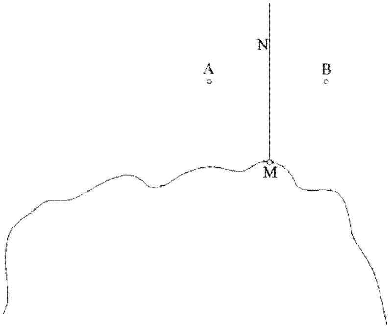
[0032] as attached figure 1 As shown, find the most advanced point on the head of the gully, point M, and draw a vertical line N perpendicular to the tangent line of point M, with a point on the vertical line N as the center, on the left and right sides of the vertical line N Two points A and B are symmetrically fixed as benchmark piles.

[0033] Step 2. Measurement of points on the edge of gully head

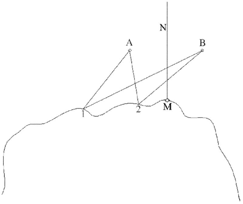
[0034] Plane shape measurement of ditch head: as attached figure 2 As shown, take A and B as the benchmark, measure the distance from the point on the ditch head to A and B, and record the reading, such as the distance from point 1 to A and B is recorded as (d 1a , d...


PUM


Abstract

The invention discloses a rapid monitoring method for headward erosion rate of a gully head, which belongs to the soil erosion field. In the method, two benchmark piles are arranged in the gully head development direction within a gully catchment, and an gully head shape position coordinate system taking a connecting line of the two benchmark piles as an x-axis and taking the midperpendicular of the connecting line of two benchmark piles as a y-axis is established; the coordinate value of each point on the gully head is obtained through the measured distance between each point on the edge of the gully head to the two datum points, and the morphological curve of the gully head edge is fitted within a period; integration is carried out to morphological curves obtained every two monitoring periods, and then the erosion area change of the gully movement within the two monitoring periods is obtained; finally, the erosion volume of the gully head is obtained according to the measured down-cutting depth changes of the gully head, and the erosion volume divided by the monitoring time is the headward erosion rate of the gully head in the period. The used instrument in the method are simple, the operation is easy, the cost is low, and therefore, the method is especially suitable for the field with complex terrain conditions, and can accurately measure the headward erosion rate of gully head.

Description

technical field [0001] The invention relates to a rapid monitoring method for the erosion rate of gully head traceability by using multi-point curve fitting and integration in the field of soil erosion, especially in the case of complex field terrain and inconvenient carrying of advanced instruments. Simple and easy method for morphology and erosion rate monitoring. Background technique [0002] The Loess Plateau, Northeast Black Soil Region, and Jinsha River dry-hot valleys in China are all distributed with large gullies. The gullies have large erosion volumes and fast cutting speeds. Sand is one of the important sources of river sediment. Carrying out research on gully erosion has far-reaching significance for sustainable economic development and river ecological security in gully-developed areas. [0003] Gully erosion monitoring is one of the important bottlenecks that limit further research on gully erosion. [0004] At present, gully monitoring methods mainly includ...

Claims


Application Information

Patent Timeline
Patent Type & Authority Applications(China)
IPC IPC(8): G01N33/24G01C15/00
Inventor 熊东红翟娟李佳佳杨丹卢晓宁苏正安董一帆
Owner INST OF MOUNTAIN HAZARDS & ENVIRONMENT CHINESE ACADEMY OF SCI
Why Eureka
Try Eureka