Vehicle-mounted laser measuring method for mining area subsidence

A technology of laser measurement and laser measurement system, which is applied in the field of vehicle-mounted laser measurement of mining area subsidence, can solve the problems of high flight cost, inability to meet the needs of subsidence monitoring work, and long field observation operation cycle

Inactive Publication Date: 2012-07-25
吴立新 +1
View PDF4 Cites 29 Cited by
  • Summary
  • Abstract
  • Description
  • Claims
  • Application Information

AI Technical Summary

Problems solved by technology

Although the use of GPS combined with conventional measurement methods can achieve higher accuracy, there are still some basic problems: 1) GPS has a high resolution in the time domain, but the resolution in the space domain cannot be very high; 2) To monitor large-scale subsidence areas, a large number of monitoring points must be arranged and maintained, and a large amount of human resources and property must be invested; 3) The stability of the reference point; 4) The field observation operation cycle is long; 5) The vertical accuracy is low; 6) Constructing a subsidence surface from subsidence point and line data must unde

Method used


Image

  • Vehicle-mounted laser measuring method for mining area subsidence
  • Vehicle-mounted laser measuring method for mining area subsidence
  • Vehicle-mounted laser measuring method for mining area subsidence

Examples


Embodiment Construction

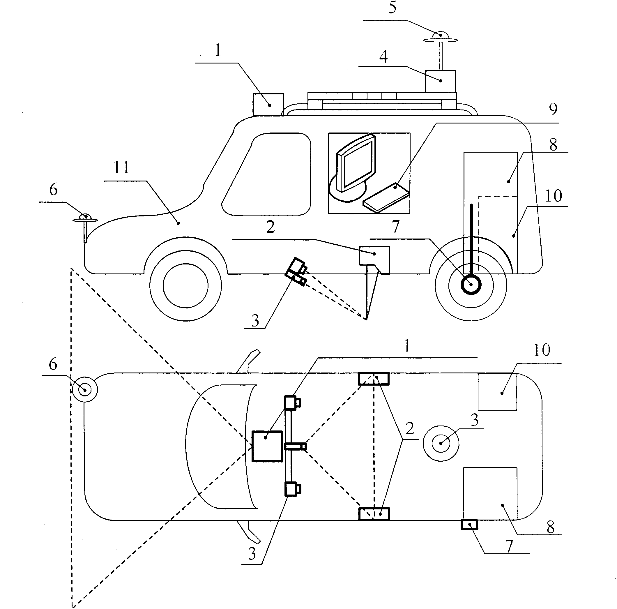
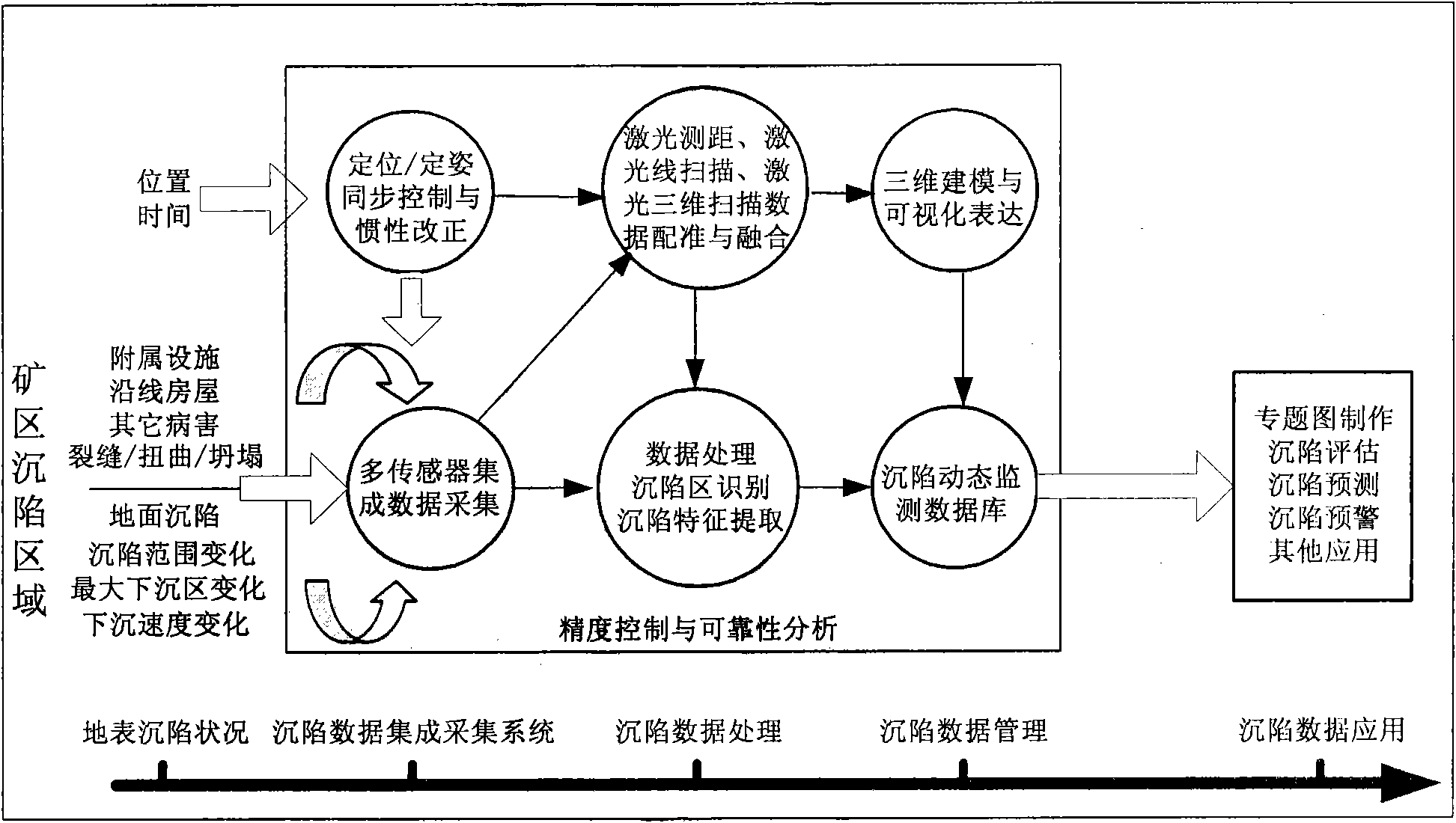
[0078] Using the vehicle-mounted laser measurement method for mining subsidence, the difference between the two measurement results of the elevation information of the surface point in the subsidence area of ​​the mining area can be calculated, and the subsidence amount can be accurately calculated to achieve high efficiency (speed 0-60Km / h), high resolution (subsidence The data sampling interval is less than 1m, and the spatial positioning accuracy of subsidence data is better than 5m), large-scale (laser measurement range can cover 80m around the driving route), and high-precision (subsidence monitoring accuracy reaches 1cm) automatic monitoring of mine subsidence. Using the vehicle-mounted laser measurement method for mining area subsidence, the surface elevation difference is detected based on time series, the subsidence area is automatically identified, and the subsidence features are extracted; then a 3D visualization model of the mining area subsidence is established, and...


PUM


Abstract

The invention discloses a vehicle-mounted laser measuring method for mining area subsidence, which faces to requirements on monitoring of ground surface subsidence caused by exploiting on the mining area, and highly effectively integrates a vehicle-mounted three-dimensional laser scanner, a laser line scanning system and a laser point distance measuring system. The method comprises the steps of observing the mining area subsidence continuously; building a high-accuracy three-dimensional model for the ground surface of the subsidence; carrying out elevation difference detection on the ground surface on the basis of a time sequence; automatically identifying a subsidence area; and extracting subsidence characteristics; building a three-dimensional visual model of the mining area subsidence; and analyzing three-dimensional space moving vectors and deformation curves of an observing point in the horizontal direction, the vertical direction and the random direction, so as to realize the time sequence analysis and three-dimensional space analysis and estimate of subsidence rang change, maximum subsidence change and subsidence speed change, so that a basis for decision making for monitoring, recovering and managing mining area environments can be provided.

Description

technical field [0001] The invention belongs to the field of mine measurement, in particular to the field of mine subsidence measurement, and relates to a vehicle-mounted laser measurement method for mine subsidence, especially by using laser point ranging, laser line scanning, laser three-dimensional scanning and GPS / IMU / acceleration value combined compensation A vehicle-mounted laser measurement method for mine subsidence technology. Background technique [0002] While the large-scale development and utilization of mineral resources has brought huge social and economic benefits to mankind, it has also caused a series of environmental problems and mining damage to human production and life. The mining subsidence of the mining area is caused by the formation of the goaf after mineral mining, and the upper rock stratum undergoes deformation such as caving, fracture, extrusion, bending, and movement under the action of gravity, etc., and spreads to the ground. It is one of the...

Claims


Application Information

Patent Timeline
IPC IPC(8): G01C5/00
Inventor 吴立新王植
Owner 吴立新
Why Eureka
Try Eureka