Tour guide and safety control method based on satellite equipment

A technology of satellite equipment and safety assurance, applied in the direction of location information-based services, instruments, electrical components, etc., can solve the problems of single positioning mode, easy location blind spots, dependence and other problems of the tour guide system, so as to achieve convenient mutual search and reliable safety guarantee service effect

Inactive Publication Date: 2012-07-25
北京中盈安信技术服务股份有限公司
View PDF3 Cites 24 Cited by
  • Summary
  • Abstract
  • Description
  • Claims
  • Application Information

AI Technical Summary

Problems solved by technology

[0003] The positioning mode of the existing tour guide system is relatively simple, and it is easy to have dead spots in the position
For example, there is a radio guide system, which requires a special launch pad and terminal equipment and can only be used in a limited area; The location of the map, and then provide tourists with information about the surrounding attractions. This guide system completely relies on the GPS positioning of the United States. Using a single positioning method can easily fail to obtain location information in places with dense buildings and mountain...

Method used


Image

  • Tour guide and safety control method based on satellite equipment
  • Tour guide and safety control method based on satellite equipment
  • Tour guide and safety control method based on satellite equipment

Examples


Embodiment Construction

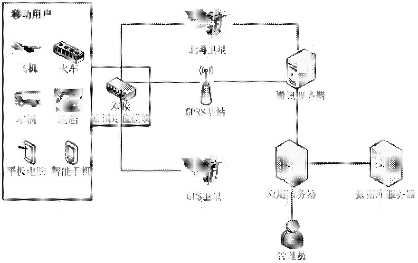
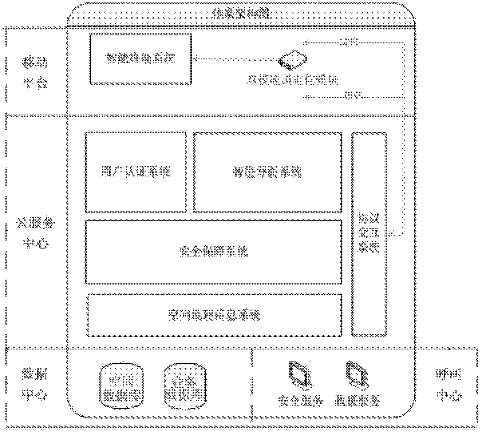
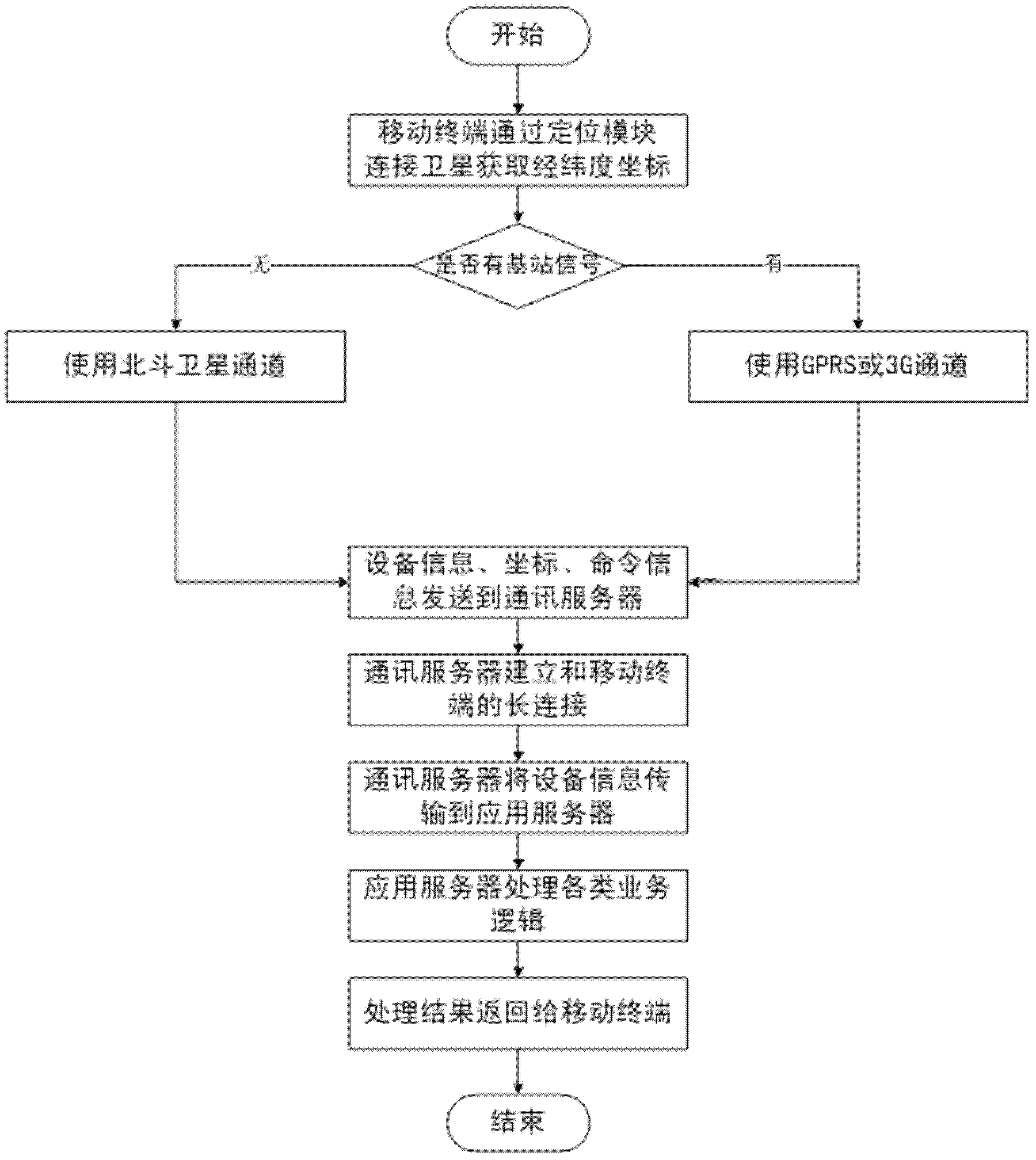
[0034] The present invention is a guide and safety assurance method based on satellite equipment such as Beidou. As we all know, the Beidou satellite navigation system is a regional active three-dimensional satellite positioning and communication system (CNSS) developed by China itself. (GPS), the third mature satellite navigation system after Russia's GLONASS. The Beidou satellite navigation system is committed to providing high-quality positioning, navigation and timing services to global users. Its construction and development follow the four principles of openness, autonomy, compatibility and gradualism. Short message service and active positioning are the characteristics and advantages of Beidou system that distinguish it from other navigation systems. Generally speaking, other intelligent navigation systems only tell you when and where, but this invention not only allows tourists to know when and what In addition to the location, it can also send its location information...


PUM


Abstract

The invention discloses a tour guide and safety control method based on satellite equipment. The method comprises the steps of: (1) acquiring longitude and latitude coordinates by connecting a satellite through a positioning module, by a mobile terminal; (2) judging whether to use a GPRS (General Packet Radio Service) or 3G (The 3rd Generation Telecommunication) communication channel or a Beidou satellite channel; (3) sending information containing the longitude and latitude coordinates to a communication server by a mobile terminal; (4) establishing persistent link with the mobile terminal through a communication server; (5) transmitting information sent by the mobile terminal to an application server through a communication server; and (6) carrying out various business logic calculations by the application server based on a data cloud service center, returning a calculation result to the mobile terminal, and by utilization of the mobile terminal, a satellite, the communication server and the application server, partially or completely completing the following operations: verifying the communication channel and recording the coordinate information and weather and disaster conditions of a current city in real time; performing navigation for lost; intelligently searching positions of accompanying partners; and automatically prompting on dangerous areas around according to user position to facilitate evasion of a user.

Description

technical field [0001] The invention relates to a satellite equipment-based tour guide and a safety guarantee method. Background technique [0002] Driven by social and economic development, the demand level of tourists is constantly increasing, and many people's travel awareness has undergone a major change, and they tend to design travel routes according to their own wishes, so they are no longer satisfied with mass tourism, which is a tourism organization that restricts individuality. In this way, outdoor activities organized by families, groups and units are increasing day by day, and the way of traveling has changed from the traditional "team travel" to the new "independent travel". The larger market brought about by these changes has also brought new problems, such as: weak travel services, poor communication channels, frequent security incidents, and so on. At present, the market for outdoor guides, travel safety and wild rescue is still quite weak. With the rapid d...

Claims


Application Information

Patent Timeline
IPC IPC(8): H04L29/08H04W4/02G06Q50/10
Inventor 夏蜀科
Owner 北京中盈安信技术服务股份有限公司
Why Eureka
Try Eureka