Method for recovering spectral information of hill shade area of Landsat thematic mapper/enhanced thematic mapper plus (TM/ETM+) image

A technology for spectral information and shadow areas, applied in the field of spectral information restoration in mountain shadow areas, can solve problems such as image fragmentation, DEM data difficulties, and streaks

Inactive Publication Date: 2012-08-01
BEIJING NORMAL UNIVERSITY
View PDF2 Cites 21 Cited by
  • Summary
  • Abstract
  • Description
  • Claims
  • Application Information

AI Technical Summary

Problems solved by technology

However, most of these algorithms require the assistance of digital elevation model data, that is, DEM data, but it is difficult to obtain DEM data with suitable spatial resolution and high precision that meet the requirements of these algorithms
For example, when performing terrain correction on Landsat TM / ETM+ images, DEM data with a spatial resolution of 30m is required, and there is currently no 30m resolution DEM data on a global scale; and in most cases, even if we have enough DEM data can cover our research area, and its resolution often does not match the remote sensing image to be processed
Therefore, in the preprocessing process of DEM data resampling and geometric registration of DEM data and remote sensing image data, additional noise and errors will inevitably be introduced, which will damage the result of terrain correction and cause the corrected image to appear fragmented and stripes

Method used


Image

  • Method for recovering spectral information of hill shade area of Landsat thematic mapper/enhanced thematic mapper plus (TM/ETM+) image
  • Method for recovering spectral information of hill shade area of Landsat thematic mapper/enhanced thematic mapper plus (TM/ETM+) image
  • Method for recovering spectral information of hill shade area of Landsat thematic mapper/enhanced thematic mapper plus (TM/ETM+) image

Examples


Embodiment Construction

[0039] In order to have a clearer understanding of the technical features, purposes and effects of the present invention, specific implementations of the present invention are now described.

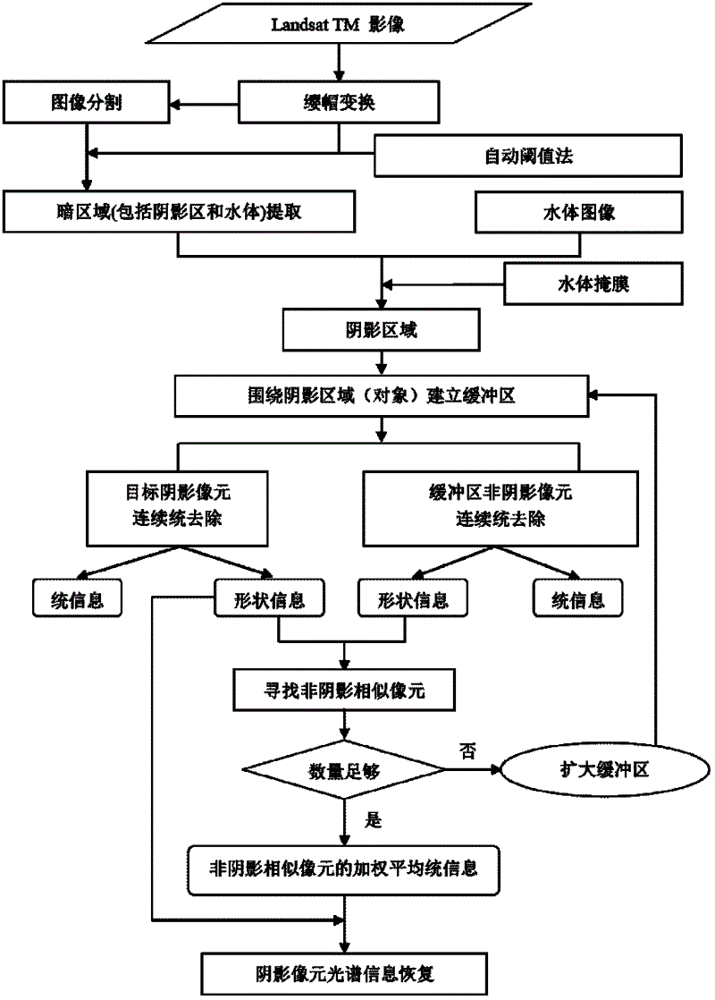
[0040] figure 1 It is a schematic flow chart of a spectral information recovery method for a hillshaded area in a Landsat TM / ETM+ image according to a specific embodiment of the present invention; refer to figure 1 As shown, the principle of a spectral information restoration method for a hillshaded area in a Landsat TM / ETM+ image according to the present invention will be described in detail below. The method comprises the steps of:

[0041] Step A identifies and extracts the shadow area;

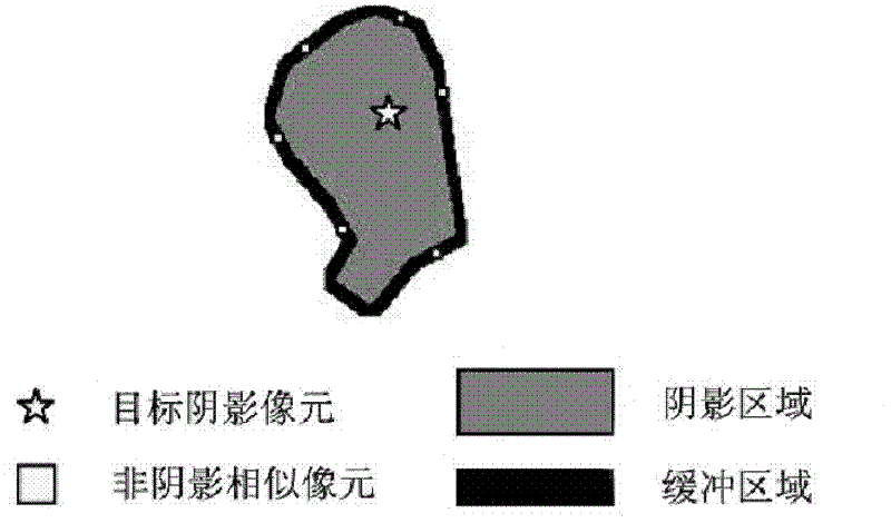
[0042] Step B non-shadow similar pixel search;

[0043] Step C restores the spectral information of the shaded area based on the spectral similarity between the shadowed pixel and its non-shadowed similar pixel.

[0044] Considering that atmospheric correction may lead to the loss of weak spectra...


PUM


Abstract

The invention provides a method for recovering spectral information of a hill shade area of a Landsat thematic mapper/enhanced thematic mapper plus (TM/ETM+) image. The method comprises the following steps of: identifying and extracting the shade area, searching unshaded similar image elements and recovering the spectral information of the shade area. The method for recovering the spectral information of the hill shade area of the Landsat TM/ETM+ image is used for recovering the spectral information of the shade area of a remote sensing image. According to the method provided by the invention, by fully combining the proper weak spectral information of shade image elements with the spectral information of similar image elements near the shade image elements, the dependence of a traditional topographic correction algorithm on digital elevation model (DEM) data is rid of. When the resolution and the accuracy of the DEM data cannot meet the requirement of the topographic correction algorithm, the algorithm is capable of providing an effective shade processing method.

Description

technical field [0001] The invention relates to a method for processing Landsat TM / ETM+ images, in particular to a method for restoring spectral information of hill shadow areas in Landsat TM / ETM+ images. Background technique [0002] For a long time, in the field of remote sensing imaging, Landsat TM / ETM+ images have a large number of applications. The US Landsat has gone through three generations. The first generation is Landsat-1 satellite, Landsat-2 satellite and Landsat-3 satellite, and the second generation is Landsat-4 Satellites and Landsat-5 satellites, the third generation is Landsat-6 satellites and Landsat-7 satellites. TM refers to the multi-band scanning images obtained by the Thematic Mapper of the US Landsat 4~5 special mapper. The TM image has 7 bands, and its spectral range is: TM-1 is 0.45~0.52 microns, TM-2 is 0.52~ 0.60 microns, TM-3 is 0.63-0.69 microns, and the above is the visible light band; TM-4 is 0.76-0.90 microns, which is the near-infrared band...

Claims


Application Information

Patent Timeline
Patent Type & Authority Applications(China)
IPC IPC(8): G06T5/50G06T7/00
Inventor 陈晋曹鑫周渊崔喜红
Owner BEIJING NORMAL UNIVERSITY
Why Eureka
Try Eureka