Combined navigation system and method

A technology of joint navigation and navigation information, which is applied in the field of navigation systems, can solve the problems of volume, power consumption, long navigation time, and decreased accuracy, and achieve the effects of improving accuracy, reducing volume and power consumption, and improving continuous positioning capabilities

Inactive Publication Date: 2012-09-05
TECHTOTOP MICROELECTRONICS
View PDF5 Cites 10 Cited by
  • Summary
  • Abstract
  • Description
  • Claims
  • Application Information

AI Technical Summary

Problems solved by technology

Therefore, the main problems currently restricting the development of joint navigation technology to small term

Method used


Image

  • Combined navigation system and method
  • Combined navigation system and method
  • Combined navigation system and method

Examples


Embodiment Construction

[0024] In order to make the object, technical solution and advantages of the present invention clearer, the present invention will be further described in detail below in conjunction with the accompanying drawings and embodiments. It should be understood that the specific embodiments described here are only used to explain the present invention, not to limit the present invention.

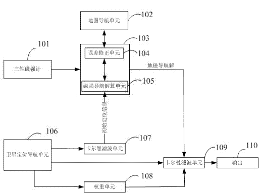
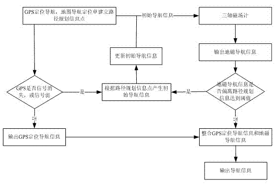
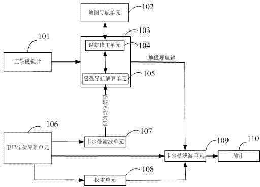
[0025] attached figure 1 It is a schematic diagram of the joint positioning and navigation system of the embodiment of the present invention. In this embodiment, the integrated navigation system includes a three-axis magnetometer, which can measure the three-component data of the geomagnetic field strength and input it to the processor unit 103. The processor unit 103 includes an error correction unit 104 for receiving the map navigation unit 102. The error correction information fed back, and the map navigation unit 102 can establish path planning information according to the navigation starting ...


PUM


Abstract

The invention provides a combined navigation system. The combined navigation system comprises a satellite positioning navigation unit, a processor unit, a weight unit and a Kalman filter unit, wherein the satellite positioning navigation unit is used for periodically outputting the satellite positioning navigation information of a moving object; the processor unit is used for periodically processing and correcting the navigation information of the moving object; the weight unit is used for periodically calculating the weight relationship among the plurality of navigation information of the moving object; and the Kalman filter unit is used for periodically calculating the navigation information of the moving object, and periodically combining the navigation information according to weights to obtain the final navigation information of the moving object. The system also comprises a three-axle magnetometer and a map navigation unit, wherein the three-axle magnetometer is used for periodically measuring the magnetic field intensity information of the moving object, and the map navigation unit is used for establishing path planning information. After the technical scheme of the invention is adopted, the continuous positioning capability of the navigation system is effectively improved, the volume and power consumption of the system are reduced, and the navigation precision is obviously improved.

Description

technical field [0001] The invention relates to a navigation system and method, in particular to a combined navigation system and method based on a satellite navigation and positioning system. Background technique [0002] With the increasing development of navigation technology, especially the emergence and maturity of satellite navigation and positioning systems (such as GPS, GLONASS, Beidou satellite positioning system, etc.), it is widely used due to its global coverage, high precision, and all-weather characteristics. Applied to all aspects of life. However, due to the fact that satellite signal propagation is affected by many factors, especially in urban environments with many buildings on the ground, satellite signal interruptions are prone to occur, making continuous positioning difficult. [0003] Aiming at this problem, there are many means to solve it, such as using inertial navigation as an auxiliary means, according to the positioning sensors commonly used in i...

Claims


Application Information

Patent Timeline
IPC IPC(8): G01S19/48
Inventor 周善明
Owner TECHTOTOP MICROELECTRONICS
Why Eureka
Try Eureka