Vector map matching navigation method for linear target in aviation

A technology of vector map and navigation method, applied in the field of vector map matching and navigation, which can solve the problems of large amount of data and low efficiency.

Active Publication Date: 2012-10-03
NANJING UNIV OF AERONAUTICS & ASTRONAUTICS
View PDF3 Cites 19 Cited by
  • Summary
  • Abstract
  • Description
  • Claims
  • Application Information

AI Technical Summary

Problems solved by technology

[0009] The purpose of the present invention is to provide a vector map matching navigation method for aviation linear targets, which can overcome the shortcomings of the existing aviation raster image matching navigation method in space efficiency and time efficiency, and avoid the existence of raster image matching. The problem of large amount of data and low efficiency, and overcome the impact of small-scale changes on vector maps, can complete vector map matching with rotation, translation and small-scale transformation

Method used


Image

  • Vector map matching navigation method for linear target in aviation
  • Vector map matching navigation method for linear target in aviation
  • Vector map matching navigation method for linear target in aviation

Examples


Embodiment Construction

[0058] The technical solutions of the present invention will be described in detail below in conjunction with the accompanying drawings.

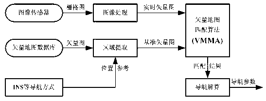
[0059] figure 1 Shown is a schematic diagram of the vector map matching navigation system. The vector map matching navigation uses the airborne image sensor to collect images of the ground or target areas, and matches the real-time vector map obtained by image processing with the vector map database pre-stored in the navigation computer. Get the navigation parameters of the aircraft. The vector map matching navigation system mainly includes four parts: image processing, area extraction, vector map matching algorithm and navigation solution.

[0060] (1) Image processing: According to the real-time collection of raster images, the corresponding real-time vector graphics are obtained after processing such as image denoising, scale unification, and vectorization, as the input source of the matching algorithm.

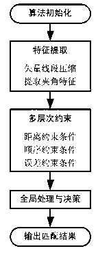
[0061] (2) Area extraction: Ac...


PUM


Abstract

The invention discloses a vector map matching navigation method for a linear target in aviation, which comprises the following steps: preparing a base vector diagram and a template vector diagram for map matching, unifying the base vector diagram and the template vector diagram under a same vector precision level, and extracting included angle characteristics of the template vector diagram and the base vector diagram; sequentially utilizing a distance constraint condition, a sequence constraint condition and an error constraint condition to gradually limit size of a feasible solution space; clustering pose parameters of the feasible solution space, taking a class containing most pose parameters as a correct matching relationship; and further computing the pose parameters to be errors for correcting an inertial navigation system by matching positioning results. The method provided by the invention can overcome shortages of space efficiency and time efficiency in the existing grid image matching navigation method for aviation and avoids the problems of large data volume, low efficiency and the like in the grid image matching; in addition, the method provided by the invention overcomes influence of small-scale change on a vector map and can achieve vector map matching under rotation, translation and small-scale change.

Description

technical field [0001] The invention relates to a vector map matching navigation (Vector Map Matching Navigation) method, in particular to a vector map matching navigation method for aviation linear targets. Background technique [0002] Scene-matching-assisted navigation technology has been successfully applied to cruise missile terminal guidance systems due to its outstanding advantages such as high measurement accuracy, strong autonomy, outstanding anti-interference ability, low system energy consumption, and high navigation accuracy. Since scene matching often uses raster images as the matching data source, the onboard reference database generally requires a large amount of storage, and the image matching algorithm usually takes a long time, which has a certain impact on the real-time performance of the navigation system. [0003] Different from scene matching navigation using raster image matching positioning, vector map matching navigation is a positioning technology b...

Claims


Application Information

Patent Timeline
Patent Type & Authority Applications(China)
IPC IPC(8): G01C21/30
Inventor 孙永荣黄斌彭靖叶张玲熊智康国华李荣冰刘建业
Owner NANJING UNIV OF AERONAUTICS & ASTRONAUTICS
Why Eureka
Try Eureka