Land resource utilization change dynamic prediction model based on GIS (Geographic Information System) and using method of dynamic prediction model

A dynamic prediction and land technology, applied in the field of geographic modeling, can solve problems such as the size and time limit of the prediction area, the inaccurate prediction results, and the difficulty in determining the characteristics of the main factors.

Inactive Publication Date: 2012-10-24
张公达
View PDF0 Cites 12 Cited by
  • Summary
  • Abstract
  • Description
  • Claims
  • Application Information

AI Technical Summary

Problems solved by technology

The disadvantage of this model is that it is not suitable for large-scale forecasting and the error of forecast value caused by the difficulty of quantifying economic factors
The model calculation only needs to consider the current information of land use, without considering the internal mechanism of land use change. The disadvantage is that the model lacks the ability to reveal the driving mechanism of land dynamic change and the lack of spatial expression ability. This model is suitable for the driving force of land use change Change Mechanisms Are Unclear and Status of Predicting Short-term Land Use Change
The advantage of this model is that it can analyze dynamic data and induce laws based on historical data. The disadvantage is that it is limited by the size of the forecast area and the length of time. It is difficult to determine the characteristics of some main factors, and the forecast results are not very accurate.

Method used


Image

  • Land resource utilization change dynamic prediction model based on GIS (Geographic Information System) and using method of dynamic prediction model
  • Land resource utilization change dynamic prediction model based on GIS (Geographic Information System) and using method of dynamic prediction model
  • Land resource utilization change dynamic prediction model based on GIS (Geographic Information System) and using method of dynamic prediction model

Examples


Embodiment Construction

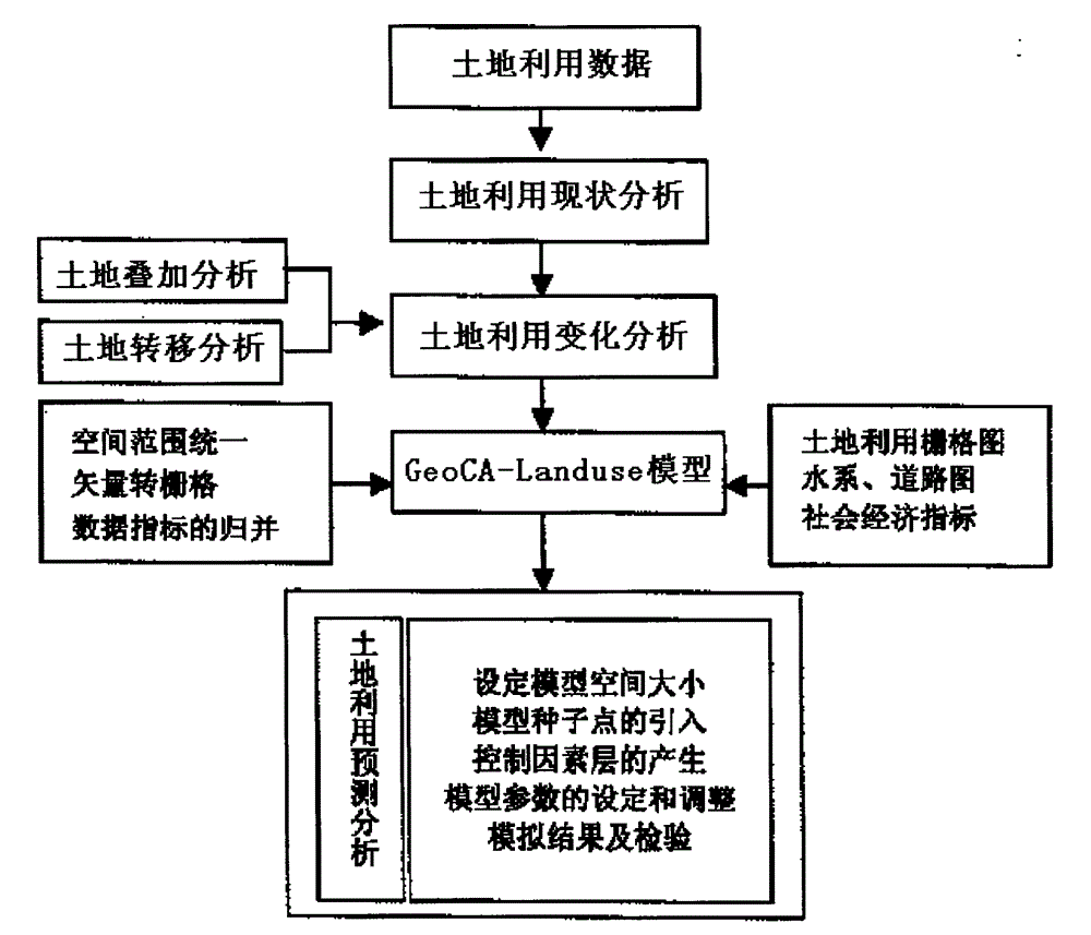
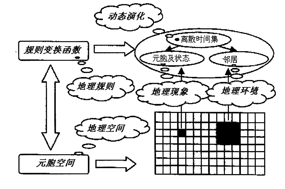
[0027] according to figure 1 and figure 2 Given the geographic cellular automata model structure and the integration method with GIS, the technical solution of the present invention will be further described below.

[0028] 1. GeoCA-Landuse model construction steps

[0029] 1. Set the size of the model space

[0030] Setting the size of the model space is to create a space for cell growth, which is the first condition for the model to run. Limited by memory and CPU speed, the model supports calculations below 5000×5000. The cell size of the model selection in the present invention is 200×200m, and the model space is 1023×2127.

[0031] 2. Introduction of model seed points

[0032] In this model, the seed point is the initial state of land use development in the study area, the land use change is based on the seed point, and the seed point is the growth point of the land use change. Therefore, the distribution of seed points should truly reflect the pattern of land chang...


PUM


Abstract

The invention relates to a land resource utilization change dynamic prediction model based on a GIS (Geographic Information System) and a processing method. The basic idea of the GeoCA (cellular automaton)-Landuse model on simulating land utilization change is as follows: vital signs of a land unit are introduced, and the dynamic evolution of land utilization type is simulated; starting with the overlay analysis and transition analysis of two time phase land utilization thematic maps, and combining with the metering model of land utilization change, the land utilization dynamic change feature is analyzed; the model control factors are analyzed according to a river system and traffic map in a researched area, and a control factor layer is constructed; combining with social economic data, the model parameters are adjusted, and reasonable neighbors and transformation rules are determined; and with the powerful spatial data processing and analyzing functions of the GIS, the land utilization change trend is simulated and predicted according to the change process of history land utilization. According to the model and the method disclosed by the invention, the simulation on dynamic trend and evolution rule of land utilization change is realized, and scientific basis is provided for scientific decision-making.

Description

technical field [0001] The invention relates to the technical field of geographic modeling, in particular to a method for dynamic prediction of land use change. Background technique [0002] The land use change model is to reveal the magnitude, speed and spatial distribution of land use change on the basis of the analysis of land use change. It analyzes the driving factors of land use and their relationship, explores the mechanism of land use change, and predicts The trend of future land use change and its impact on the ecological environment and socio-economic development. The current background technologies of land use trend prediction can be summarized into the following types, all of which have their own advantages and disadvantages; [0003] 1) Regression prediction method is a method of forecasting by using mathematical equations that indicate the relationship between variables to infer the value of the predictor variable from the known values ​​​​of other variables. ...

Claims


Application Information

Patent Timeline
Patent Type & Authority Applications(China)
IPC IPC(8): G06T17/05
Inventor 张公达
Owner 张公达
Why Eureka
Try Eureka