Cooperative real-time path planning method for multiple unmanned aerial vehicles (UAVs) in case of communication latency

A multi-drone, communication delay technology, applied in the field of real-time route planning, can solve the problems of being out of communication range, unable to carry out message transmission and data exchange, and not considering the influence of communication constraints, so as to avoid collision and maintain communication.

Inactive Publication Date: 2012-10-31
NORTHWESTERN POLYTECHNICAL UNIV
View PDF4 Cites 38 Cited by
  • Summary
  • Abstract
  • Description
  • Claims
  • Application Information

AI Technical Summary

Problems solved by technology

[0003] This algorithm does not consider the influence of communication constraints on the route planning algorithm, and ensuring communication is the basic element of multi-UAV cooperation
If multiple UAVs are too far apart

Method used


Image

  • Cooperative real-time path planning method for multiple unmanned aerial vehicles (UAVs) in case of communication latency
  • Cooperative real-time path planning method for multiple unmanned aerial vehicles (UAVs) in case of communication latency
  • Cooperative real-time path planning method for multiple unmanned aerial vehicles (UAVs) in case of communication latency

Examples


Embodiment Construction

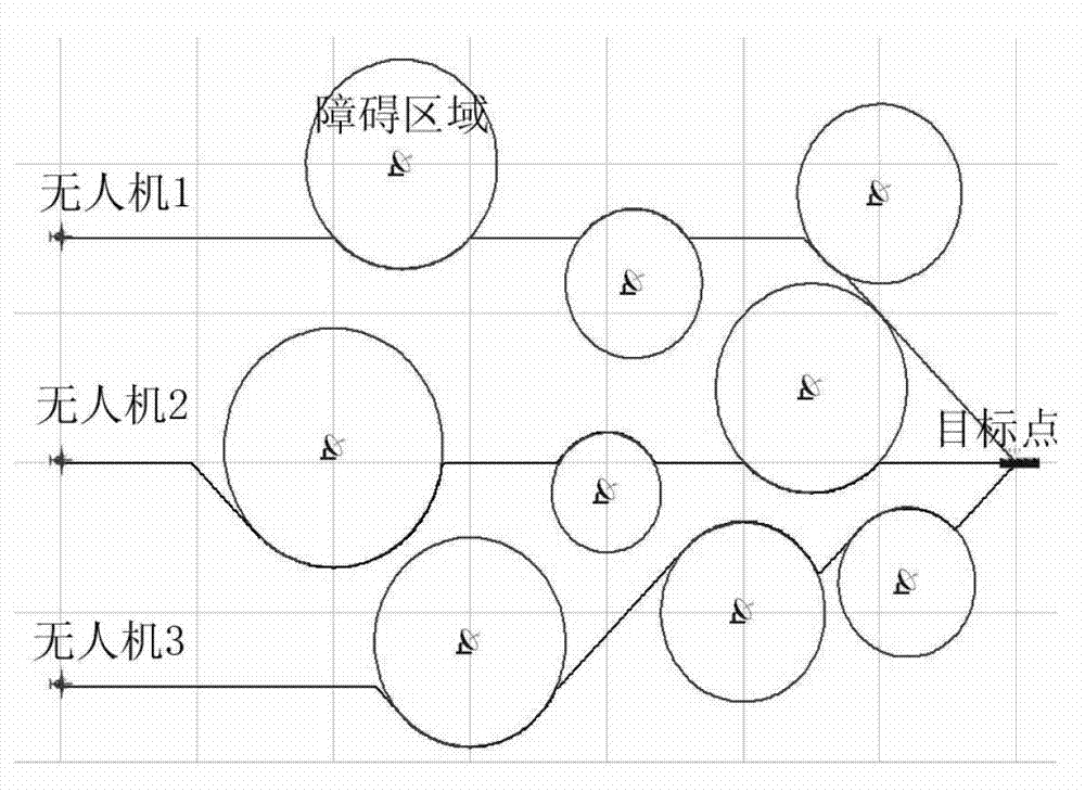
[0047] Assume that the step size of the algorithm execution is Δt, and the initial step size is Δt 0 , the types of UAVs participating in the route planning are the same, and the UAVs are all flying at the same height, and the speed range of the UAVs is v∈(v min , v max ), the minimum safe distance between drones is d min , the maximum communication distance is d max , after executing the communication delay, the minimum distance between UAVs is d′ min , the maximum distance is d′ max . The steps performed by the algorithm are as follows (see attached figure 1 ):

[0048] Step 1: Set the drone data, obstacle data and target point data to generate a digital map for the A* algorithm to call.

[0049] UAV data includes: the number n of UAVs, the initial position coordinates of UAVs (x i ,y i )(i=1, 2, ..., n);

[0050] The obstacle data includes: the number of obstacles m, the center coordinates of the obstacle circle (x j ,y j ), radius rj (j=1,2,...,m);

[0051] Th...


PUM


Abstract

The invention discloses a cooperative real-time path planning method for multiple unmanned aerial vehicles (UAVs) in case of communication latency. UAV data, obstacle data and target point data are firstly set to generate a digital map; then a simultaneous arrival constraint is executed, and the flight speed of each UAV is obtained; a communication latency constraint is executed, and the spacing range of the UAVs is obtained; an A-* algorithm is executed, and the next path of each UAV is obtained; and whether conditions of a collision avoidance constraint and a communication distance restriction are satisfied or not is judged, and whether the UAVs arrive a target point or not is finally judged. By adopting the cooperative real-time path planning method, the multiple UAVs can take off from different places and simultaneously arrive at the same target point under the condition of communication latency and can avoid obstacles on the way; the collision among the UAVs is avoided; and meanwhile, the communication among the UAVs can be kept.

Description

technical field [0001] The invention relates to a real-time route planning method for multiple unmanned aerial vehicles to take off from different locations and fly to the same target point while avoiding obstacle areas. Related fields include path planning, cooperative control and communication technology. Background technique [0002] Multi-UAV collaborative route planning is the most basic task in multi-UAV collaborative planning. It is the basis for multi-UAV to perform other tasks such as collaborative search and collaborative tracking. It can be applied to personnel search, The location, survey and detection of the accident site have been extensively studied at home and abroad. Xi Yongjun and Zhou Deyun proposed a multi-UAV cooperative route planning algorithm based on the improved A* algorithm in the paper "Research on Multi-UAV Cooperative Attack Path Planning". Firstly, the framework of the multi-UAV optimal cooperative attack path planning system is constructed; s...

Claims


Application Information

Patent Timeline
IPC IPC(8): G01C21/20
Inventor 符小卫李建高晓光李波
Owner NORTHWESTERN POLYTECHNICAL UNIV
Why Eureka
Try Eureka