Multi-target remote sensing image segmentation method based on decomposition

A remote sensing image and multi-target technology, applied in the field of image processing, can solve problems such as single evaluation index, high computational complexity, and poor detail retention performance, and achieve the effect of improving accuracy and reducing computational complexity

Active Publication Date: 2012-11-28
XIDIAN UNIV
View PDF2 Cites 26 Cited by
  • Summary
  • Abstract
  • Description
  • Claims
  • Application Information

AI Technical Summary

Problems solved by technology

[0006] Aiming at the shortcomings of the above-mentioned existing technologies, such as single evaluation index, high computational complexity

Method used


Image

  • Multi-target remote sensing image segmentation method based on decomposition
  • Multi-target remote sensing image segmentation method based on decomposition
  • Multi-target remote sensing image segmentation method based on decomposition

Examples


Embodiment 1

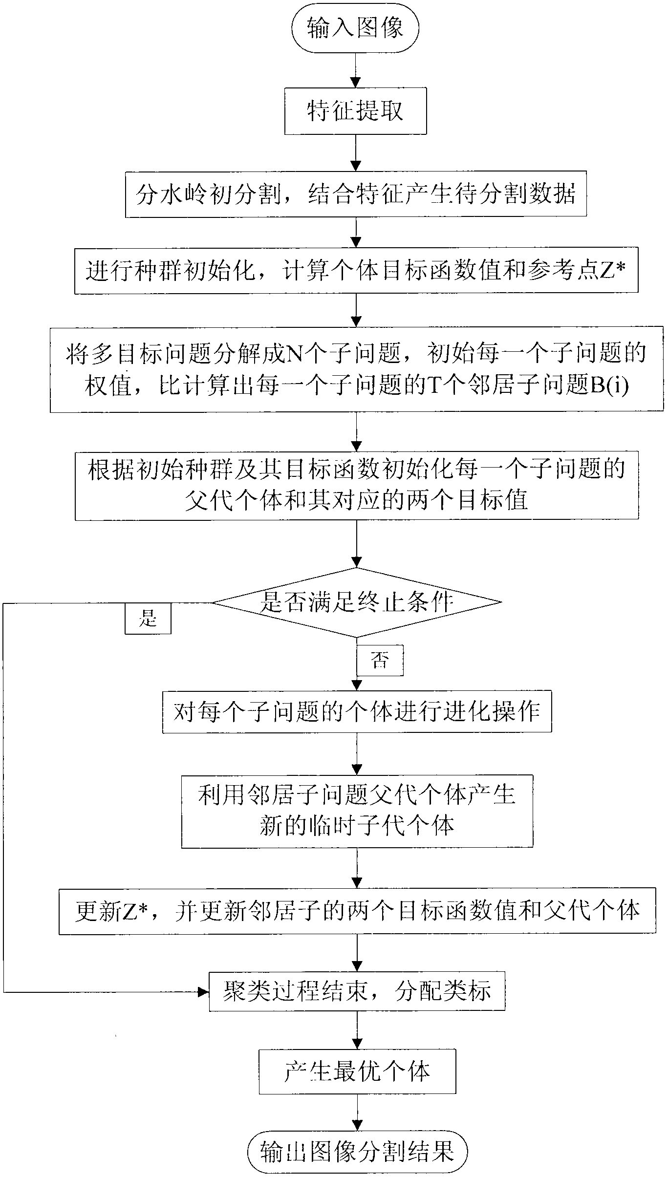
[0066] The present invention is a multi-target remote sensing image segmentation method based on decomposition, belongs to the technical field of image processing, and further relates to a segmentation method in the technical field of remote sensing image segmentation. The simulation of this example is carried out in the hardware environment of Pentium Dual_Core CPU E5200 with a main frequency of 2.3GHZ, a memory of 2GB, and a software environment of MATLAB R2009a.

[0067] The invention is a multi-target remote sensing image segmentation method based on decomposition. Aiming at the shortcomings of the prior art such as single evaluation index, high computational complexity, and poor detail retention performance, the invention proposes a multi-target remote sensing image segmentation method based on decomposition. Image Segmentation Methods. In the method, the fusion feature is extracted as the data to be clustered to better preserve the image details; two complementary object...

Embodiment 2

[0109] The multi-target remote sensing image segmentation method based on decomposition is the same as embodiment 1. In order to possess practicability, the present invention is further described in detail as follows:

[0110] Wherein the further detailed description of image feature extraction in step 2 is as follows:

[0111] 2.1.1 The process of extracting texture feature vectors by using the gray level co-occurrence matrix method includes: firstly, the image to be processed is quantized into 16 gray levels, and then the angle between the line connecting two pixel points and the horizontal axis is 0° , 45°, 90° and 135°, respectively calculate the gray level co-occurrence matrix in the four directions according to the following formula:

[0112] P(i,j)=#{(x 1 ,y 1 ), (x 2 ,y 2 )∈M×N|f(x 1 , y1x)=r, f(x 2 ,y 2 )=s}

[0113] Among them, P(i, j) is the element of the gray level co-occurrence matrix at the coordinate (i, j), # is the number of elements in the set {}, (x...

Embodiment 3

[0136] The multi-target remote sensing image segmentation method based on decomposition is the same as embodiment 1-2, and the segmentation effect of the present invention can be further illustrated by the following experiments:

[0137] The experimental simulation environment is: Pentium Dual_Core CPU E5200 with a main frequency of 2.3GHz, a hardware environment with a memory of 2GB, and a software environment of MATLAB R2009a.

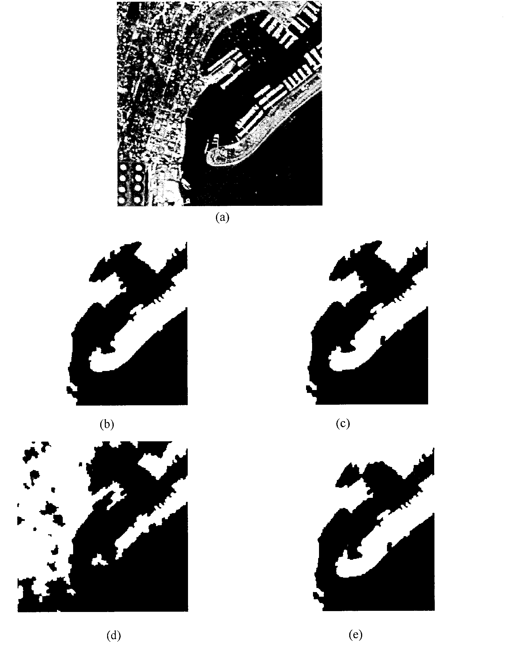
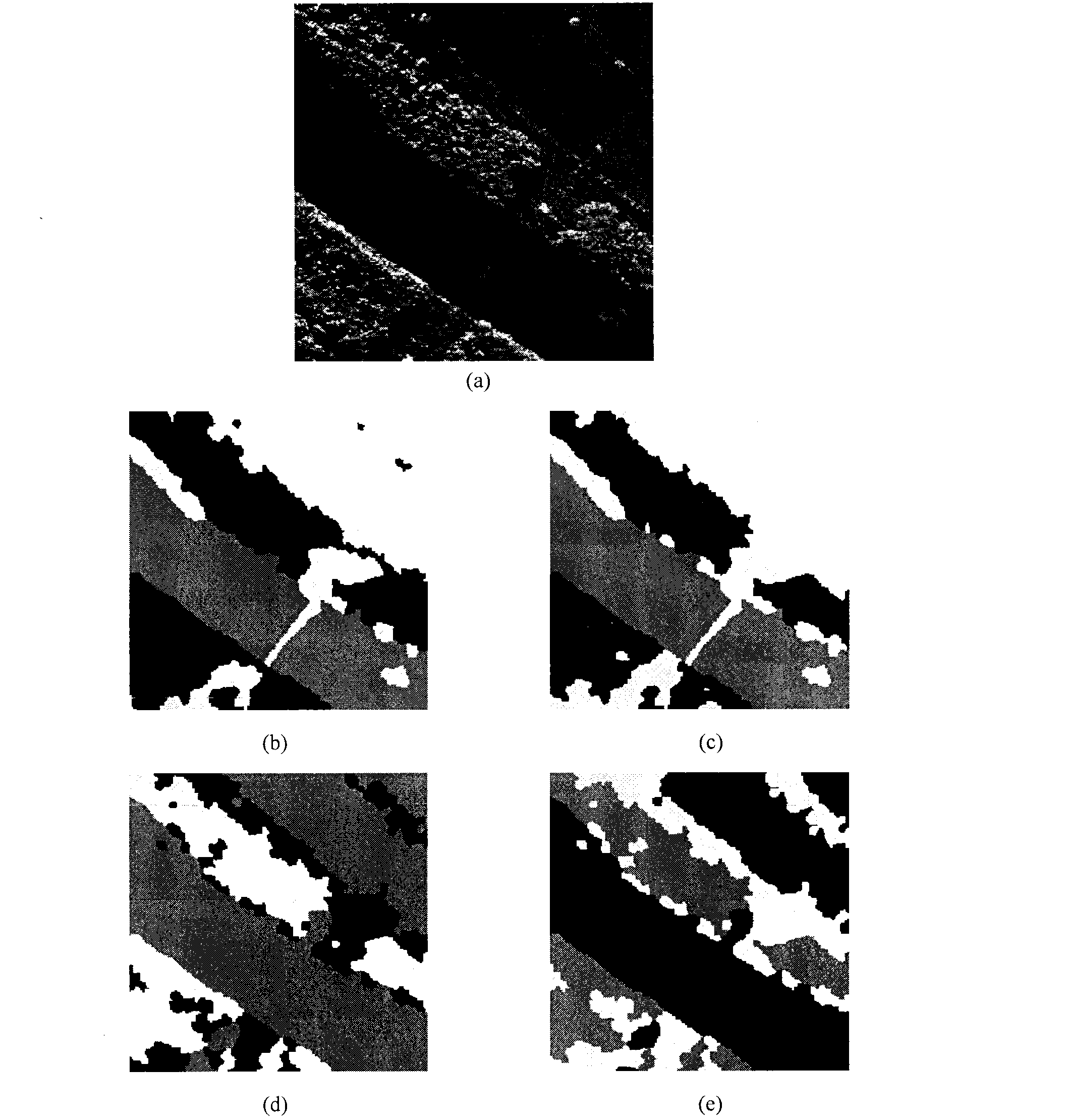
[0138] figure 2 (a) is the optical remote sensing test image used in the simulation experiment. This optical remote sensing image data is part of the port map of Shelter Island in San Diego area. There are two types of labels, one is land and the other is water. The image size is 256 ×256. Using the decomposition-based multi-target remote sensing image segmentation method of the present invention to figure 2 (a) Segmentation is performed.

[0139] In the experiment, the An Evolutionary Approach to Multiobjective Clustering (MOCK) in the prior ar...


PUM


Abstract

The invention discloses a multi-target remote sensing image segmentation method based on decomposition, which mainly solves the problems of the existing image segmentation technology, such as single evaluation index, high computing complexity and bad segmentation effect. The method mainly comprises the following steps of: inputting a remote sensing image to be segmented; extracting the characteristics of the image to be segmented; generating clustered data; initializing the initial population; calculating the fitness value of individual; initializing the sub-problems; evolving the individuals in each sub-problem; judging whether the termination condition is met to allocate a category label; generating the optimal individual; and outputting the segmented image. The method disclosed by the invention extracts the fusion characteristics of each pixel of the image and generates super-pixel characteristics in combination with watershed coarse division; and decomposing multiple target problems into a series of sub-problems through a decomposition multi-target method to realize the segmentation of a remote sensing image. The method disclosed by the invention has the advantages of diverse evaluation indexes, low computing complexity, good detail maintenance and the like, realizes high image segmentation precision and accurate edge positioning, and can be applied to the segmentation of a complicated image.

Description

technical field [0001] The invention belongs to the technical field of image processing, and further relates to an evolution-based image segmentation method in the technical field of remote sensing image segmentation, in particular to a multi-target remote sensing image segmentation method based on decomposition. It is used to segment optical remote sensing images and synthetic aperture radar (SAR) images to achieve target recognition. Background technique [0002] Image segmentation is the technology and process of dividing an image into several specific regions with unique properties and extracting objects of interest. At present, people mostly use methods based on cluster analysis for image segmentation. The image segmentation based on the cluster analysis method is to represent the pixel points in the image space with the points in the corresponding feature space, segment the points in the feature space according to their aggregation in the feature space, and then map t...

Claims


Application Information

Patent Timeline
IPC IPC(8): G06T7/00G06N3/00G06T7/11G06T7/162
Inventor 李阳阳焦李成魏莹刘若辰缑水平尚荣华马文萍于昕
Owner XIDIAN UNIV
Why Eureka
Try Eureka