Integrated navigation system for autonomous underwater robot and method

A technology of integrated navigation system and underwater robot, which is applied in the directions of navigation, surveying and navigation, navigation calculation tools, etc. It can solve the problems of accumulation, attitude and speed data errors, and it is difficult to suppress the heading angle error of the integrated navigation system, so as to achieve improvement Effect of System Accuracy

Inactive Publication Date: 2012-12-19
JIANGSU UNIV OF SCI & TECH
View PDF7 Cites 52 Cited by
  • Summary
  • Abstract
  • Description
  • Claims
  • Application Information

AI Technical Summary

Problems solved by technology

However, there are certain errors in the above attitude and velocity data, and these errors will accumulate to an unacceptable level over time
The research results show that the integrated navigation system based on timing receiving GPS correction can provide measurement acc

Method used


Image

  • Integrated navigation system for autonomous underwater robot and method
  • Integrated navigation system for autonomous underwater robot and method
  • Integrated navigation system for autonomous underwater robot and method

Examples


Example Embodiment

[0052] The present invention will be further described below in conjunction with the accompanying drawings and specific embodiments.

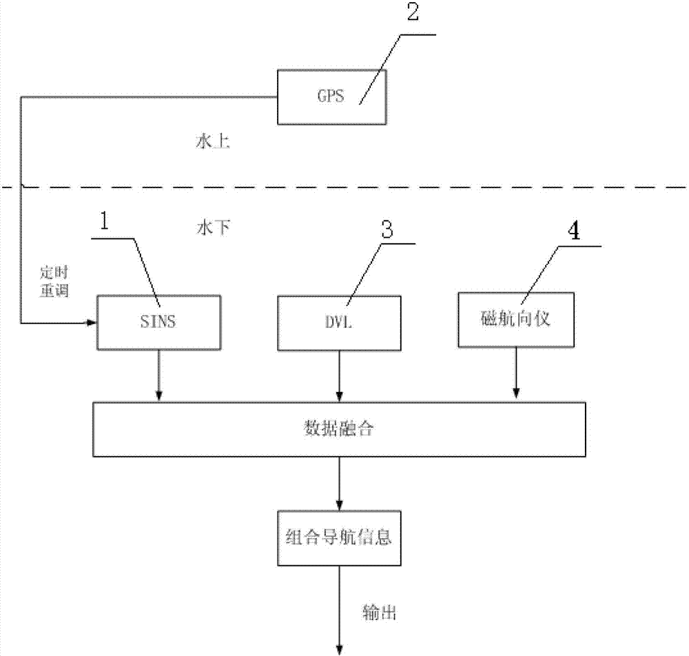
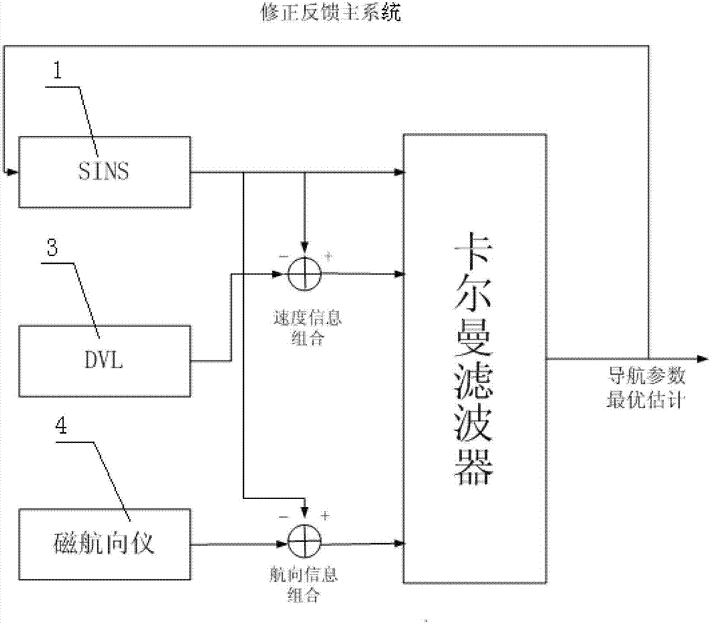
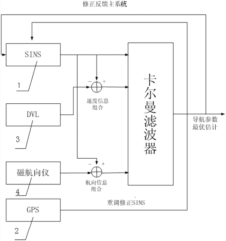
[0053] like figure 1 As shown, the autonomous underwater robot integrated navigation system is composed of a strapdown inertial navigation system 1, a global positioning navigation system 2, a Doppler velocimeter 3, and a magnetic direction indicator 4. The strapdown inertial navigation system 1 utilizes a gyroscope and the accelerometer to calculate the speed information, position information and attitude information relative to the earth along the geographic coordinate system; the global positioning and navigation system 2 obtains the initial absolute position information and speed information of the autonomous underwater robot; the Doppler velocimeter 3. Calculate the speed information; the magnetic heading device 4 calculates the heading information; the global positioning navigation system 2 readjusts the strapdown inertial navigation syst...


PUM


Abstract

The invention discloses an integrated navigation system for an autonomous underwater robot. The integrated navigation system is composed of a strapdown inertial navigation system, a global positioning navigation system, a Doppler speed meter and a magnetic heading device, wherein the speed information, the position information and the gesture information relative to the earth along a geographic coordinate system are calculated by the strapdown inertial navigation system; initial absolute position information and speed information of the autonomous underwater robot are obtained by the global positioning navigation system; the speed information is calculated by the Doppler speed meter; the heading information is calculated by the magnetic heading device; the timing for the strapdown inertial navigation system is readjusted by the global positioning navigation system; and the system is used for performing data fusion on the speed information, the position information and the gesture information outputted by the strapdown inertial navigation system, the speed information calculated by the Doppler speed meter and the heading information calculated by the magnetic heading device through self-adaption fuzzy Kalman filtering, so that accurate integrated navigation information is obtained.

Description

technical field [0001] The invention relates to a navigation technology, in particular to an autonomous underwater robot combined navigation system and method, belonging to the field of marine engineering. Background technique [0002] With the development of modern science and technology, Autonomous Underwater Vehicle (AUV) has a wide range of applications in both military and civilian applications, such as theater reconnaissance, detection and removal of mines, maritime early warning, underwater search and mapping, offshore Petroleum engineering operations, etc. As far as the current development is concerned, navigation technology is the key to realizing autonomous navigation of AUVs. The navigation system must provide accurate positioning, speed and attitude information over long distances and over a long period of time. However, due to the limitations of its size, weight, power usage, and the particularity and concealment of water media, it is a difficult task to realiz...

Claims


Application Information

Patent Timeline
IPC IPC(8): G01C21/00G01C21/16G01C21/20
Inventor 曾庆军王冲王彪章飞刘利
Owner JIANGSU UNIV OF SCI & TECH
Why Eureka
Try Eureka