Method and device for checking spatial data

A technology of spatial data and query methods, applied in the field of geographic information systems, can solve problems such as slow query speed, and achieve the effect of improving speed

Active Publication Date: 2012-12-19
北京世纪天宇科技发展有限公司
View PDF3 Cites 2 Cited by
  • Summary
  • Abstract
  • Description
  • Claims
  • Application Information

AI Technical Summary

Problems solved by technology

[0004] The technical problem to be solved in this application is to provide a spatial data query method and device to solve the problem of slow query speed when the amount of query spatial data in the prior art is large

Method used


Image

  • Method and device for checking spatial data
  • Method and device for checking spatial data
  • Method and device for checking spatial data

Examples


Embodiment 1

[0057] In the first embodiment, a spatial data query method proposed in this application is introduced in detail.

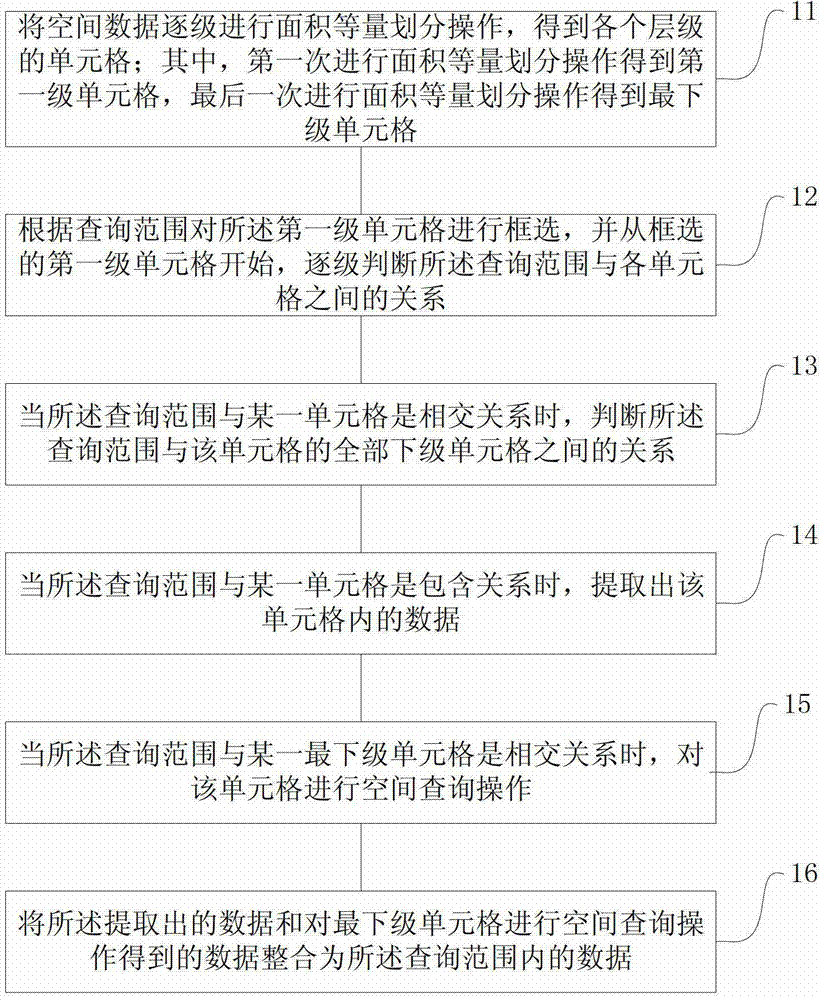
[0058] refer to figure 1 , shows a flowchart of a spatial data query method described in Embodiment 1 of the present application.

[0059] Step 11, divide the spatial data level by level to obtain the cells of each level; among them, the first level of cells is obtained by performing the area equal division operation for the first time, and the final area is obtained by the area equal division operation. Subordinate cell;

[0060] Spatial data generally have a certain range, such as the national vegetation type map, covering the whole country; the three-district map of Beijing, covering the area of ​​Beijing. Therefore, when the spatial data is put into the database, it will be preprocessed according to two principles, that is, the minimum cell area <10 square kilometers (the default value, which can be set freely); and the number of data in the minimum cell <2...

Embodiment 2

[0085] Embodiment 2 introduces in detail a spatial data query method proposed in this application.

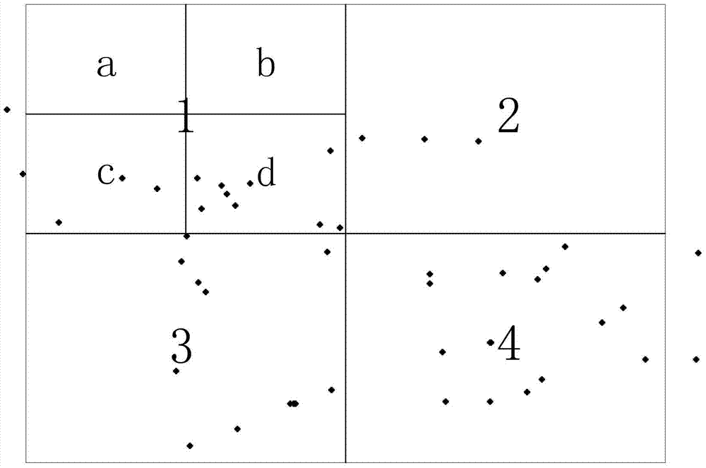
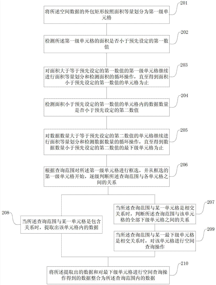
[0086] refer to image 3 , shows a flow chart of a spatial data query method described in Embodiment 2 of the present application.

[0087] Step 201, dividing the enclosing rectangle of the spatial data into first-level cells according to equal area;

[0088] The spatial data generally has a certain range, but most of the ranges are not regular graphics, so before performing an equal-area division operation on the spatial data, the surrounding rectangle of the range where the spatial data is located must be obtained first, Then perform an equal-area division operation on the surrounding rectangle.

[0089] Perform the first area equal division operation on the enclosing rectangle to obtain the first-level cells.

[0090] The equal division of the area includes:

[0091] At least one of quarters, nines, or sixteens.

[0092]The area equal division operation can be divided i...

Embodiment 3

[0127] The third embodiment introduces in detail a spatial data query device proposed in this application.

[0128] refer to Figure 4 , shows a structural diagram of a spatial data query device described in Embodiment 3 of the present application.

[0129] The spatial data query device includes:

[0130] Area equivalence division module 31 , frame selection module 32 , relationship judgment module 33 , data extraction module 34 , spatial query module 35 , and data integration module 36 .

[0131] The functions of each module and the relationship between each module are introduced in detail below.

[0132] The area equivalent division module 31 is used to perform the area equal division operation on the spatial data level by level to obtain the cells of each level; wherein, the area equal division module performs the area equal division operation for the first time to obtain the first level For the cell, the area equal division module performs the area equal division operat...


PUM


Abstract

The invention provides a method and a device for checking spatial data, which solve the problem that in the prior art, the checking speed is low while a larger quantity of spatial data are checked. The method comprises the steps of carrying out area equivalent division operation on spatial data so as to obtain a table cell of each hierarchy; carrying out frame selection on the table cell according to a checking range, and judging the relationship between the checking range and each table cell from a table cell of the first hierarchy; when the relationship is of an intersecting relation, judging the relationship between the checking range and all table cells (of lower hierarchies) of the table cell; when the relationship is of a inclusion relation, extracting the data inside the table cell; when the checking range is in an intersecting relation with one table cell of the lowest hierarchy, carrying out the spatial checking operation on the table cell; and integrating the extracted data and the data checked through the spatial checking on the table cell of the lowest hierarchy into the data within the checking range. With the adoption of the method and the device, the spatial data are processed in layers and partitions so as to obtain table cells which are few enough in both covering area and information quantity, so that the speed in spatial data checking is increased.

Description

technical field [0001] This application relates to the technical field of geographic information systems, in particular to a spatial data query method and device. Background technique [0002] GIS is not only an applied engineering technology for managing and analyzing spatial data, but also an applied basic discipline spanning earth science, information science and space science. Its technical system consists of computer hardware, software and related methods and processes to support the collection, management, processing, analysis, modeling and display of spatial data in order to solve complex planning and management problems. The operation object of geographic information system is spatial data and attribute data, that is, geographical entities with three-dimensional elements such as point, line, surface and volume. The most fundamental characteristic of spatial data is that each data is coded according to a unified geographical coordinate, so as to realize its positioni...

Claims


Application Information

Patent Timeline
Patent Type & Authority Applications(China)
IPC IPC(8): G06F17/30
Inventor 李嵩郑国柱
Owner 北京世纪天宇科技发展有限公司
Why Eureka
Try Eureka