A spatial data query method and device
A technology of spatial data and query method, applied in the field of geographic information system, can solve problems such as slow query speed, and achieve the effect of improving speed
- Summary
- Abstract
- Description
- Claims
- Application Information
AI Technical Summary
Problems solved by technology
Method used
Image
Examples
Embodiment 1
[0057] In the first embodiment, a spatial data query method proposed in this application is introduced in detail.
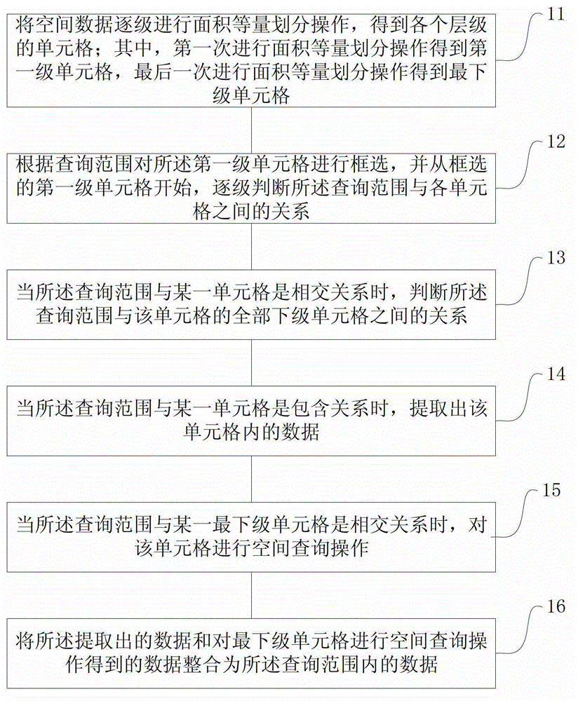
[0058] refer to figure 1 , shows a flowchart of a spatial data query method described in Embodiment 1 of the present application.
[0059] Step 11, divide the spatial data level by level to obtain the cells of each level; among them, the first level of cells is obtained by performing the area equal division operation for the first time, and the final area is obtained by the area equal division operation. Subordinate cell;
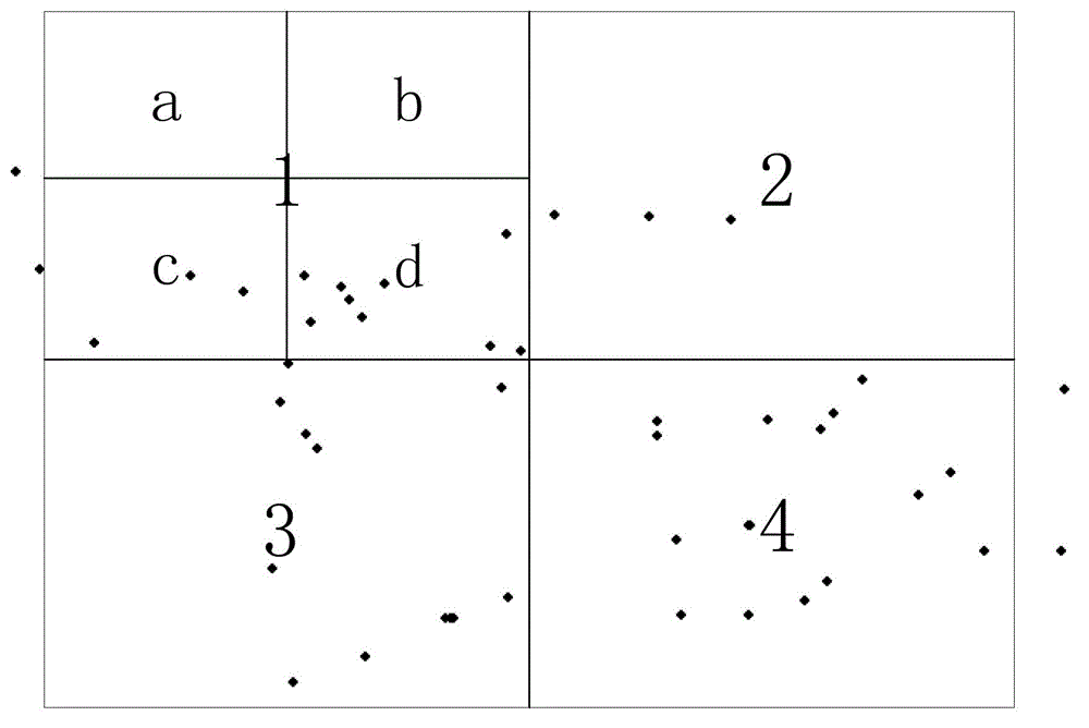
[0060] Spatial data generally have a certain range, such as the national vegetation type map, covering the whole country; the three-district map of Beijing, covering the area of Beijing. Therefore, when the spatial data is put into the database, it will be preprocessed according to two principles, that is, the minimum cell area <10 square kilometers (the default value, which can be set freely); and the number of data in the minimum cell <2...
Embodiment 2
[0085] Embodiment 2 introduces in detail a spatial data query method proposed in this application.
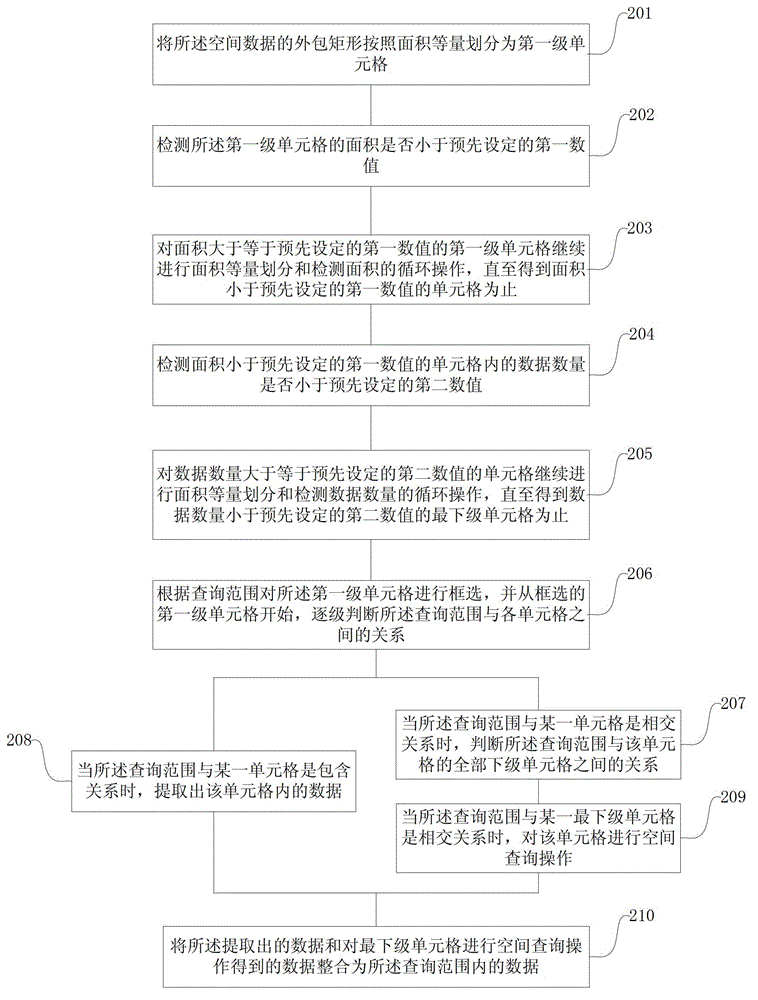
[0086] refer to image 3 , shows a flow chart of a spatial data query method described in Embodiment 2 of the present application.
[0087] Step 201, dividing the enclosing rectangle of the spatial data into first-level cells according to equal area;
[0088] The spatial data generally has a certain range, but most of the ranges are not regular graphics, so before performing an equal-area division operation on the spatial data, the surrounding rectangle of the range where the spatial data is located must be obtained first, Then perform an equal-area division operation on the surrounding rectangle.
[0089] Perform the first area equal division operation on the enclosing rectangle to obtain the first-level cells.
[0090] The equal division of the area includes:
[0091] At least one of quarters, nines, or sixteens.
[0092]The area equal division operation can be divided i...
Embodiment 3
[0127] The third embodiment introduces in detail a spatial data query device proposed in this application.
[0128] refer to Figure 4 , shows a structural diagram of a spatial data query device described in Embodiment 3 of the present application.
[0129] The spatial data query device includes:
[0130] Area equivalence division module 31 , frame selection module 32 , relationship judgment module 33 , data extraction module 34 , spatial query module 35 , and data integration module 36 .
[0131] The functions of each module and the relationship between each module are introduced in detail below.
[0132] The area equivalent division module 31 is used to perform the area equal division operation on the spatial data level by level to obtain the cells of each level; wherein, the area equal division module performs the area equal division operation for the first time to obtain the first level For the cell, the area equal division module performs the area equal division operat...
PUM
 Abstract
Description
Claims
Application Information
 - R&D
- Intellectual Property
- Life Sciences
- Materials
- Tech Scout
- Unparalleled Data Quality
- Higher Quality Content
- 60% Fewer Hallucinations
Browse by: Latest US Patents, China's latest patents, Technical Efficacy Thesaurus, Application Domain, Technology Topic, Popular Technical Reports.
© 2025 PatSnap. All rights reserved.Legal|Privacy policy|Modern Slavery Act Transparency Statement|Sitemap|About US| Contact US: help@patsnap.com


