Automatic registration method for multi-temporal empty spectrum remote sensing image based on space comprehensive mutual information

A remote sensing image and automatic registration technology, applied in the field of computer image processing and remote sensing, can solve the problems of unable to achieve high robust automatic registration, reduce the automation degree of mutual information registration model, etc., and achieve high performance automatic registration , the effect of high robustness

Active Publication Date: 2012-12-26
广州蓝图地理信息技术有限公司
View PDF2 Cites 12 Cited by
  • Summary
  • Abstract
  • Description
  • Claims
  • Application Information

AI Technical Summary

Problems solved by technology

Therefore, in the process of using the optimization algorithm to find the best parameters, it is necessary to manually determine the search range, which greatly reduces the degree of automation of the mutual information registration model.
[0005] The two basic image registration algorithms based on feature elements and image grayscale have their own defects, and cannot achieve highly robust automatic registration.

Method used


Image

  • Automatic registration method for multi-temporal empty spectrum remote sensing image based on space comprehensive mutual information
  • Automatic registration method for multi-temporal empty spectrum remote sensing image based on space comprehensive mutual information
  • Automatic registration method for multi-temporal empty spectrum remote sensing image based on space comprehensive mutual information

Examples


Embodiment Construction

[0035] The technical solutions of the present invention will be further described below in conjunction with the accompanying drawings and embodiments.

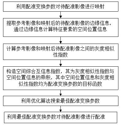
[0036] Such as figure 1 Shown is a flow chart of the present invention, a method for automatic registration of multi-temporal-spatial spectrum remote sensing images based on spatially integrated mutual information, specifically comprising the following steps:

[0037] (S1) Using the registration transformation parameters to map the image to be registered;

[0038] (S2) Extract the edge information of the reference image and the mapped image to be registered, and calculate the spatial position information of the feature elements through the edge information;

[0039] (S3) Calculating the gray similarity index between the reference image and the image to be registered after mapping;

[0040] (S4) Construct a spatial comprehensive mutual information index, which is the product of the gray similarity index and the spatial positi...


PUM


Abstract

The invention belongs to the field of computer image process and a remote sensing technology and relates to an automatic registration method for a multi-temporal empty spectrum remote sensing image based on space comprehensive mutual information. The automatic registration method comprises the following steps of: mapping an image for registering by using a registration transformation parameter; extracting the marginal information of a reference image and the mapped image for registering, and calculating the space position information of a characteristic element by the marginal information; calculating a gray similarity index between the reference image and the mapped image for registering; structuring the space comprehensive mutual information index which is a product of the gray similarity index and the space position information, wherein the space position information and the gray similarity index are object functions of the registration transformation parameter; searching an optimal registration transformation parameter by using an optimization algorithm; and registering the image by utilizing the optimal registration transformation parameter. According to the automatic registration method, the space comprehensive mutual information is constructed to be similarity index, so that the automatic registration which is high in precision, robustness and performance among multi-source remote sensing images is achieved.

Description

technical field [0001] The invention belongs to the technical field of computer image processing and remote sensing, and relates to an automatic registration method of multi-temporal-spatial spectrum remote sensing images based on spatial comprehensive mutual information. Background technique [0002] The image registration similarity index is used to evaluate the coincidence degree between the reference image and the transformed image to be registered. When the two images are fully registered, the similarity index should reach the maximum value. Since the similarity index is a function of the registration transformation parameters, finding the best registration parameters is equivalent to a function optimization problem. The quality of the similarity index determines the robustness and accuracy of the automatic registration model. [0003] In the prior art, digital image registration algorithms can be divided into two types: registration based on gray information and regist...

Claims


Application Information

Patent Timeline
Patent Type & Authority Applications(China)
IPC IPC(8): G06T7/00
Inventor 刘小平黎夏黄康宁梁嘉咏许晓聪
Owner 广州蓝图地理信息技术有限公司
Why Eureka
Try Eureka