Satellite technology-based wide area geological disaster forecasting system and method

A technology of geological disasters and satellites, applied in seismology, alarms, geophysical surveys, etc., can solve problems such as small data transmission range, unstable monitoring system, and insufficient sampling of ground surface displacement data, so as to protect national life and property safe effect

Inactive Publication Date: 2013-01-09
CHENGDU LINHAI ELECTRONICS
View PDF5 Cites 4 Cited by
  • Summary
  • Abstract
  • Description
  • Claims
  • Application Information

AI Technical Summary

Problems solved by technology

The surface displacement sensor is greatly affected by the environment, insufficient sampling of the surface displacement data, small data transmission range, unstable monitoring system, etc.
At present, there is no method for comprehensive collection of surface displacement data in wide-area areas and a monitoring system for stable and effective early warning and forecasting of geological disasters

Method used


Image

  • Satellite technology-based wide area geological disaster forecasting system and method

Examples


Embodiment Construction

[0033] The present invention will be further described in detail below in conjunction with test examples and specific embodiments. However, it should not be understood that the scope of the above subject matter of the present invention is limited to the following embodiments, and all technologies realized based on the content of the present invention belong to the scope of the present invention.

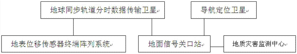
[0034] like figure 1 As shown, a wide-area geological hazard prediction system based on satellite technology, the system includes a space segment and a ground segment; the space segment includes geosynchronous orbit time-sharing data transmission satellites (high-orbit GEO satellites) and navigation and positioning satellites (medium-high Orbit satellite MEO-GEO); the ground segment includes the surface displacement sensor terminal array system, the ground signal gateway station and the geological disaster monitoring center;

[0035] The surface displacement sensor terminal arr...


PUM


Abstract

The invention discloses geosynchronous satellite time-sharing data transmission technology and satellite navigation positioning technology-based wide area geological disaster forecasting system and method. The system comprises a space section and a earth section, wherein the space section consists of a geosynchronous time-sharing data transmission satellite (geostationary earth orbit, GEO) and a navigation positioning satellite (medium earth orbit-geostationary earth orbit, MEO-GEO); the earth section consists of a earth surface displacement sensor terminal array system, a earth signal gate station, and a geological disaster monitoring center; the geological disaster monitoring center analyze the earth surface displacement distribution situation according to the information acquired by the earth surface displacement sensor terminal array system and sent by the geosynchronous time-sharing data transmission satellite and the navigation positioning satellite, analyzes and discovers the regions possibly having geological disaster dangers by utilizing an earth surface displacement-geological disaster trend mathematical model established in advance, and sending a caution command to all regions in the interior of the motoring center in time so as to ensure enough response time before the geological disaster occurs, thus loss of national life and property is avoided.

Description

technical field [0001] The invention relates to a wide-area geological disaster forecasting system and method, in particular to a wide-area geological disaster forecasting system and method based on satellite technology. Background technique [0002] At present, the early warning and forecasting system of geological disasters in a wide area is mainly for the relative movement of the surface due to the release of terrain energy after the precipitation reaches the saturation level of the ground soil to absorb water, and the occurrence of debris flows, landslides, etc. is harmful to human life and property. Accident early warning for geological disasters causing hazards. At present, the acquisition of such geological disaster early warning data generally relies on weather forecasting, precipitation measurement, manual on-duty, manual inspection of displacement areas, etc., in a localized, small-scale, and data-lag manner. Existing forecast methods need to arrange a large numbe...

Claims


Application Information

Patent Timeline
Patent Type & Authority Applications(China)
IPC IPC(8): G08B21/10G08B25/00G01V1/00
Inventor 刘铁华吴伟林王小玲宋慧
Owner CHENGDU LINHAI ELECTRONICS
Why Eureka
Try Eureka