
Forest classification method based on object-oriented high-resolution remote sensing image

A remote sensing image, high-resolution technology, applied in the direction of instruments, character and pattern recognition, computer components, etc., can solve the gap between the number of types that can be separated and the classification accuracy requirements, the minimum area of ​​​​forest division is large, and the forest division Roughness and other problems, to ensure classification consistency and results comparability, good operability and repeatability, high resolution effect

Inactive Publication Date: 2013-05-08
CHINESE RES ACAD OF ENVIRONMENTAL SCI
View PDF0 Cites 46 Cited by
  • Summary
  • Abstract
  • Description
  • Claims
  • Application Information

AI Technical Summary

Problems solved by technology

However, there are still many problems in the application of remote sensing technology in the investigation and monitoring of forest resources. There is a huge gap between the requirements
This is especially the case in southern forest areas with complex topography, fragmented forest distribution, diverse species and types, and complex structure; second, the forest division is too rough, and the minimum map area is much larger than the technical standard requirements
Due to the low and medium spatial resolution remote sensing images used in the past, the minimum area of ​​forest division is too large and the scale of the map is small

Method used


Image

  • Forest classification method based on object-oriented high-resolution remote sensing image
  • Forest classification method based on object-oriented high-resolution remote sensing image
  • Forest classification method based on object-oriented high-resolution remote sensing image

Examples


Embodiment Construction

[0027] (1) Embodiment selection

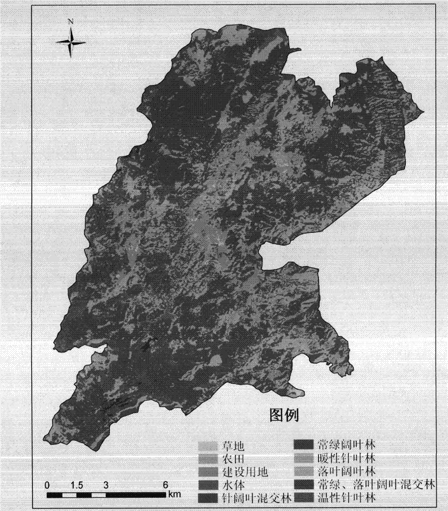
[0028] Jinggangshan National Nature Reserve is selected as an example. This reserve is located in the southwest of Jiangxi Province, China (E114°04′~16′, N26°38′~40′,) with a total area of ​​214.99km 2 , a nature reserve of forest ecosystem type, is the most complete subtropical natural evergreen broad-leaved forest reserve at the same latitude in the world. The composition of the forest flora in the reserve is ancient and complex, and it is an ancient and relatively complete Cenozoic Tertiary forest ecosystem left over about 60 million years ago. The terrain in the area is complex, with majestic mountains, vertical and horizontal gullies, high terrain in the west and south, and low in the east and north. The climate is warm and humid, with an average annual temperature of 14-17°C, an annual precipitation of 1865.5 mm, and a frost-free period of 250 days. It belongs to the subtropical humid monsoon climate zone. The reserve is located in a t...


PUM


Abstract

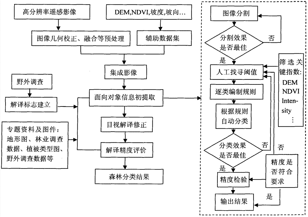
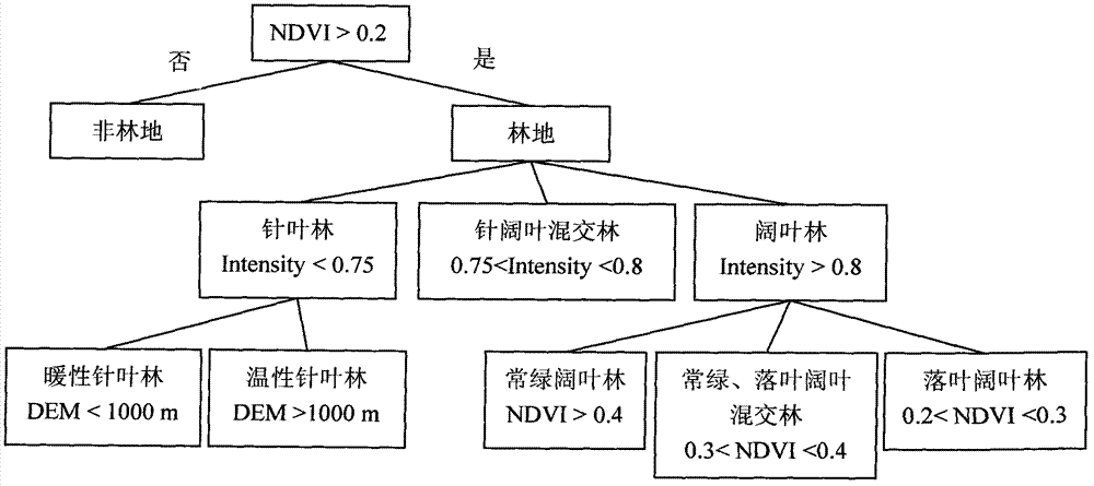
The invention discloses a forest classification method based on an object-oriented high-resolution remote sensing image. The method is based on the high-resolution remote sensing image, an object-oriented image classification method is used, an orienting remote sensing forest second-level classification system is established, a forest remote sensing classification auxiliary data set and an integrated image are created, key indexes which can distinguish forest types are selected, and a layered step-by-step classification extraction method is provided to be used for establishing information extraction knowledge rules of various forest types. The processes of the method are suitable for middle-small-scale forest resource remote sensing monitoring in a zone, good operability and repeatability are achieved, and efficiency and accuracy of forest remote sensing monitoring in the zone can be effectively improved.

Description

Technical field: [0001] The invention relates to geographic information system, remote sensing, landscape ecology and forest ecology. Background technique: [0002] Forest is the largest ecosystem on land, the pillar of the earth's life system, the adjustment center of terrestrial ecological balance, the necessary guarantee and development basis for human survival, and plays an irreplaceable role in supporting sustainable economic and social development. Forest is a renewable resource. Under the joint action of human factors and natural forces, natural growth and death, artificial logging and regeneration make the forest ecosystem in a dynamic process of alternation of growth and decline all the time. Forest resources, mainly composed of forests, woods and woodlands, are obviously a dynamic resource. Carry out forest resources investigation and monitoring, conduct continuous follow-up investigations on the state of forest resources in a certain space and time, grasp its cur...

Claims


Application Information

Patent Timeline
Patent Type & Authority Applications(China)
IPC IPC(8): G06K9/62G06K9/54
Inventor 张林波张继平沃笑徐翠张海博
Owner CHINESE RES ACAD OF ENVIRONMENTAL SCI
Learn More