Wide-range high-precision matched digital channel three-dimensional visualization method

A digital waterway and large-scale technology, applied in image data processing, instruments, calculations, etc., can solve the problem of huge amount of data and information, and achieve a strong sense of immersion and realistic visual effects

Inactive Publication Date: 2013-06-12
UNIT 63680 OF PLA
View PDF3 Cites 34 Cited by
  • Summary
  • Abstract
  • Description
  • Claims
  • Application Information

AI Technical Summary

Problems solved by technology

However, the visual modeling of the Yangtze River channel involves many objects and a huge amount of data information. How to efficiently organize the complex spatial information, how to overcome the influence of the curvature of the earth on terrain generation, and how to quickly and accurately build a large-scale 3D view of the channel , these are the technical problems that need to be solved

Method used


Image

  • Wide-range high-precision matched digital channel three-dimensional visualization method
  • Wide-range high-precision matched digital channel three-dimensional visualization method
  • Wide-range high-precision matched digital channel three-dimensional visualization method

Examples


Embodiment Construction

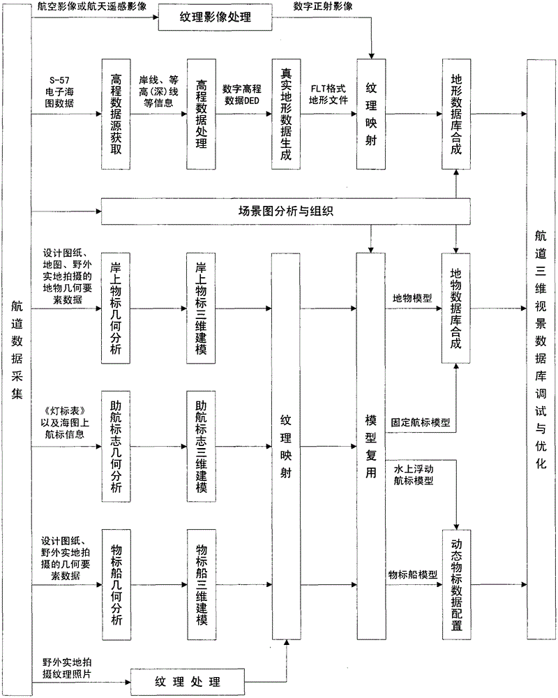
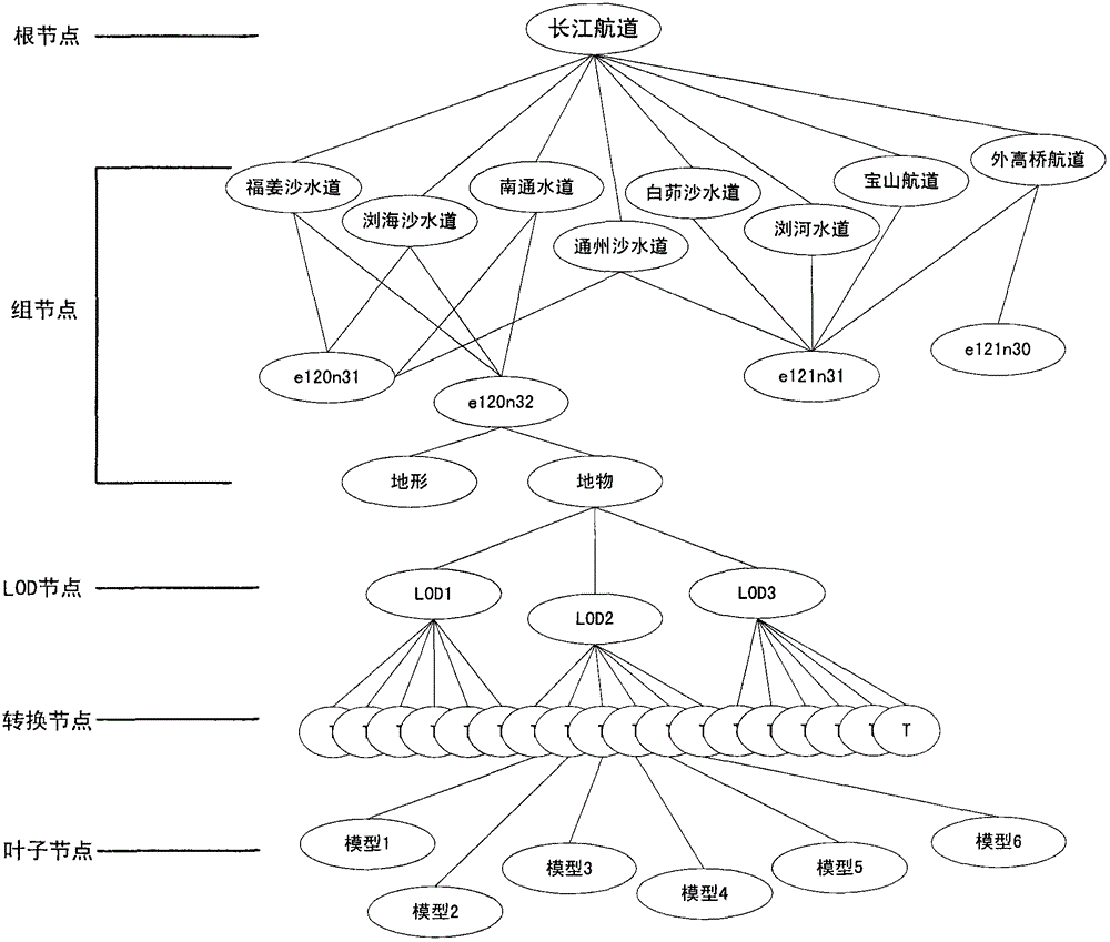
[0035] Taking the construction of the Yangtze River waterway (Jiangyin Bridge to the Yangtze River Estuary) 3D visual model library as an example, the specific implementation methods are as follows figure 1 As shown, the detailed description is as follows:

[0036] 1 Waterway data analysis and organization

[0037] 1.1 Channel data analysis

[0038] (1) Terrain analysis. The channel of the Yangtze River is a tidal section from below Jiangyin. The channel is wide and the shoreline is often blurred. The islands and shoals in the middle of the river change frequently, and the channel changes frequently. The main shoals are Fujiangsha, Tongzhousha and Baimaosha. Therefore, the terrain model of the channel should conform to the geographical information provided by the contour (depth) line data on the nautical chart, and meet the operator's need for landmark positioning such as contour line recognition of land objects and scene map recognition and underwater The needs of waterway...


PUM


Abstract

The invention provides a wide-range high-precision matched digital channel three-dimensional visualization method. For a scene graph technology-based channel scene organization method and an incremental component-based similar model modeling method, a wide-range channel terrain which accords with earth curvature change and is completely matched with an electronic chart is established, a k-crossing tree structure scene graph of a channel scene three-dimensional entity model is established, and the channel scene three-dimensional entity model which has the characteristics of wide ranges of three dimension, dynamic and scene, irregular entity and the like is organized, expressed, multiplexed and parallelly quickly developed; and based on a dynamic data configuration technology, a database paging scheduling policy is combined, and the wide-range channel three-dimensional entity model is subjected to high-precision matching, dynamic management and real-time smooth drawing. By the method, wide-range channel high-precision and high-efficiency three-dimensional visualization is realized, and inland water transportation boatmanship training and the visualization construction of Yangtze River digital channels are promoted.

Description

Technical field: [0001] The invention relates to a three-dimensional visualization method of a waterway, in particular to a large-scale high-precision matching digital waterway three-dimensional visualization method, which can be applied to the three-dimensional visualization of the Yangtze River digital waterway. Background technique: [0002] In order to promote the economic development of the Yangtze River Basin, the state proposed in 2003 to build the Yangtze River digital waterway system. Before 2020, the prototype of the Yangtze River digital waterway should be realized, and the Yangtze River waterway should be digitized, informatized, and virtualized. Among them, the realization of three-dimensional visualization is the main form of expression of the digital Yangtze River. With the support of virtual reality technology and based on geographical coordinates, how to visually describe the main channel of the Yangtze River and related auxiliary facilities with multi-dimen...

Claims


Application Information

Patent Timeline
Patent Type & Authority Applications(China)
IPC IPC(8): G06T17/00G06T15/00
Inventor 李彩霞宋元朱伟康周锦标何剑伟冯朝阳李智王艺胡蕾牛海刘喜作许林周周晶
Owner UNIT 63680 OF PLA
Why Eureka
Try Eureka