A cold chain logistics monitoring system based on Beidou/gps navigation and positioning

A cold chain logistics and Beidou technology, applied in satellite radio beacon positioning system, radio wave measurement system, comprehensive factory control, etc., can solve problems such as shortage, out of line shelf life prediction, and decline in product quality, achieving low complexity, Improve quality and realize the effect of informatization

Inactive Publication Date: 2015-09-30
UNIV OF SHANGHAI FOR SCI & TECH
View PDF4 Cites 0 Cited by
  • Summary
  • Abstract
  • Description
  • Claims
  • Application Information

AI Technical Summary

Problems solved by technology

[0004] At present, my country's cold chain logistics is just in its infancy, and there are still many problems in monitoring, mainly manifested in insufficient hardware facilities and imperfect technology; no complete and independent cold chain logistics system has been formed; lack of overall upstream and downstream planning, logistics The key to these problems, such as the easy disconnection of the process, is the lack of reasonable and effective cold chain logistics monitoring and real-time remote data transmission devices
Although my country's current monitoring of cold chain logistics is developing in the direction of informatization, automation and intelligence, and advanced monitoring equipment such as GPS positioning and GPRS data transmission have also been introduced, due to the limitations of the characteristics of GPS itself and in remote areas The coverage of mobile base stations is low, and GPRS cannot transmit data well, and it is difficult to truly meet the needs of cold chain logistics. However, Beidou can realize long-distance data transmission. The more open the place, the better the signal
In addition, almost none of the existing cold chain monitoring equipment in my country has an E-TTI device, which will lead to disconnection and failure of shelf life prediction, especially in situations where temperature fluctuations are likely to occur, such as loading and unloading, and will lead to a decline in the quality of the goods

Method used


Image

  • A cold chain logistics monitoring system based on Beidou/gps navigation and positioning
  • A cold chain logistics monitoring system based on Beidou/gps navigation and positioning
  • A cold chain logistics monitoring system based on Beidou/gps navigation and positioning

Examples


Embodiment Construction

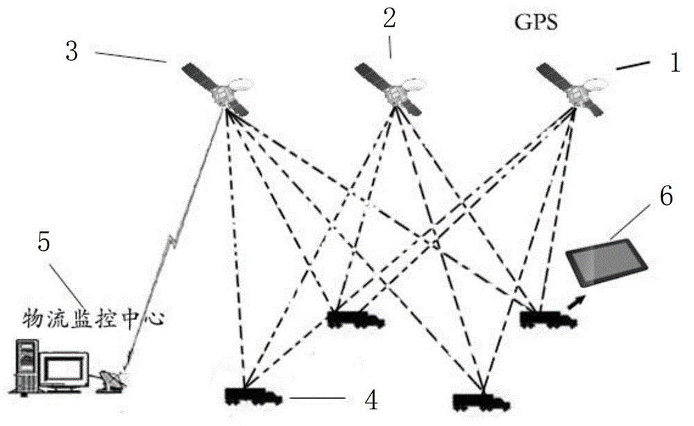
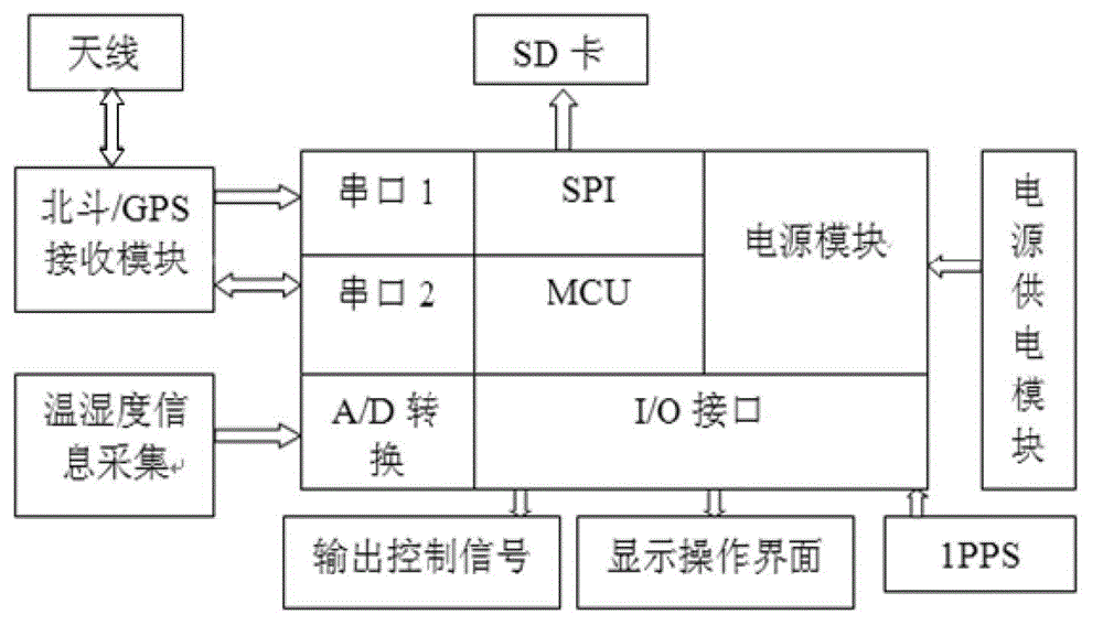
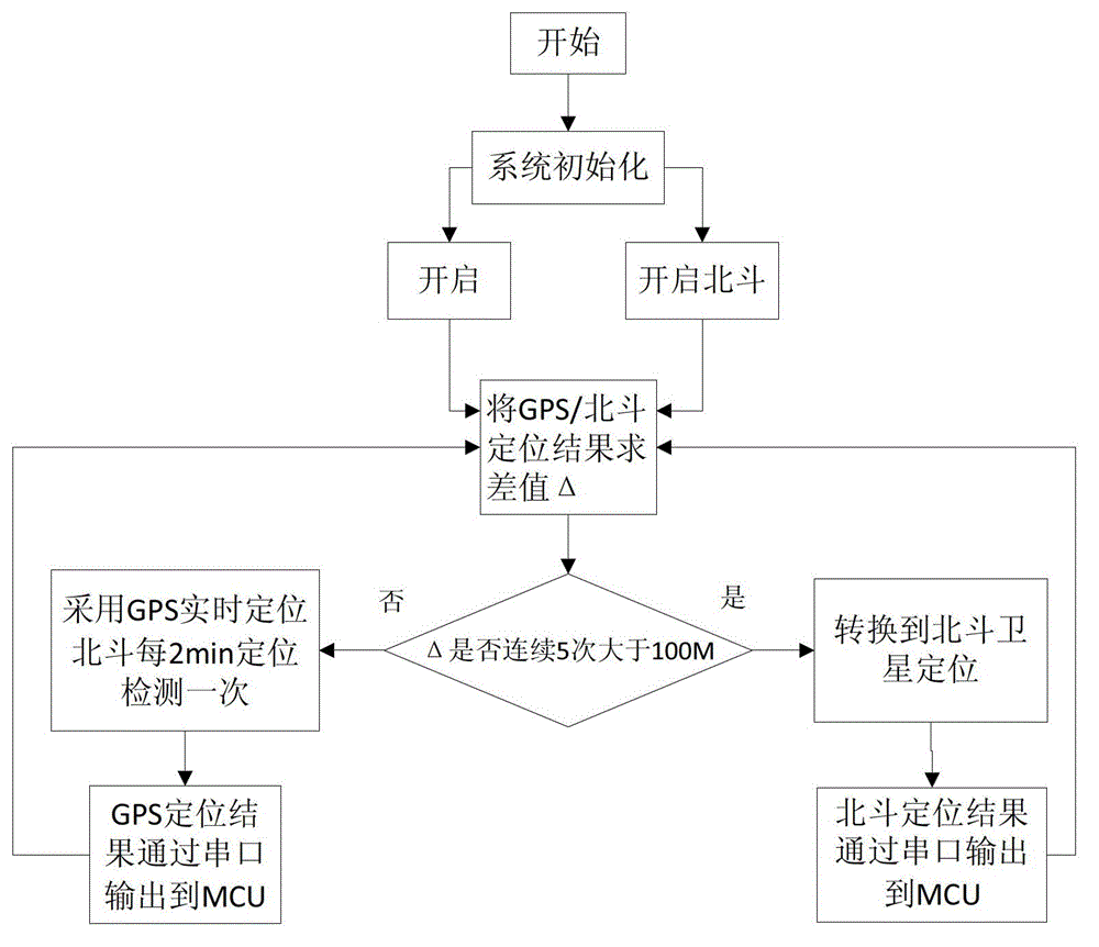
[0023] Such as figure 1 As shown, the cold chain logistics information transmission system based on Beidou / GPS dual-mode positioning, the system uses Beidou / GPS dual systems for complementary and coordinated positioning to achieve real-time accurate positioning in cold chain transportation, and Beidou is used for data transmission The short message broadcast function for communication reduces the use of mobile base stations, and the shelf life prediction in cold chain transportation is carried out according to the corresponding E-TTI model through the measured temperature information and the received timing information of Beidou / GPS satellites, so as to avoid shelf life prediction The disconnection, use the embedded development board based on Android system to detect and control the whole system, the system includes Beidou satellite positioning system 2, GPS satellite positioning system 1, Beidou data transmission 3, transported refrigerated truck 4, vehicle monitoring system 6...


PUM


Abstract

The invention discloses a cold-chain logistics monitoring system on the basis of Beidou satellite / GPS (Global Position System) navigation and positioning, which adopts the following steps of A1, setting working modes of a Beidou satellite and a GPS, preferentially using the GPS to position in the positioning process, carrying out correction and modification on positioning information of the GPS by positioning information of the Beidou satellite, when the positioning information of the GPS and the positioning information of the Beidou satellite always have a large difference in a set time range, determining that the GPS has a blind zone or a fault, and at this time, adopting the positioning information of the Beidou satellite; A2, packing the positioning information and monitoring information and transmitting the packed information to a monitoring center; and A3, acquiring a temperature signal by adopting a PT100 platinum resistor, receiving time service information of the GPS, respectively transmitting the time service information of the GPS to an embedded monitoring display module based on an Android system by an I / O (Input / Output) port and a serial port, and selecting an E-TTI (Electronic-Transmission Time Interval) model of a corresponding shelf life according to forecasting of the E-TTI model on the shelf life and shelf life models of various articles.

Description

technical field [0001] The invention belongs to the technical field of logistics, in particular to a cold chain logistics monitoring system based on Beidou / GPS navigation and positioning. Background technique [0002] Beidou satellite is a satellite navigation and positioning system independently developed by my country and compatible with any other navigation system. It is mainly composed of 5 geostationary orbit satellites and 30 non-geostationary orbit satellites, and sends carrier information positioning in three frequency bands. And with the successful launch of the 16th Beidou satellite on October 25, 2012, my country's Beidou satellite has basically realized the Asia-Pacific networking. Its main feature is that it can be applied in the comprehensive field of positioning and communication. It can not only provide all-weather navigation positioning and timing services, but also has the communication function of sending and receiving short messages, and has certain confi...

Claims


Application Information

Patent Timeline
Patent Type & Authority Patents(China)
IPC IPC(8): G05B19/418G01S19/33
Inventor 邹金成胥义王健金晶沈力
Owner UNIV OF SHANGHAI FOR SCI & TECH
Why Eureka
Try Eureka