Low-light and low-altitude remote sensing image enhancement method based on retinex theory
A low-altitude remote sensing and image enhancement technology, applied in image enhancement, image data processing, instruments, etc., to solve problems such as image color distortion
- Summary
- Abstract
- Description
- Claims
- Application Information
AI Technical Summary
Problems solved by technology
Method used
Image
Examples
Embodiment Construction
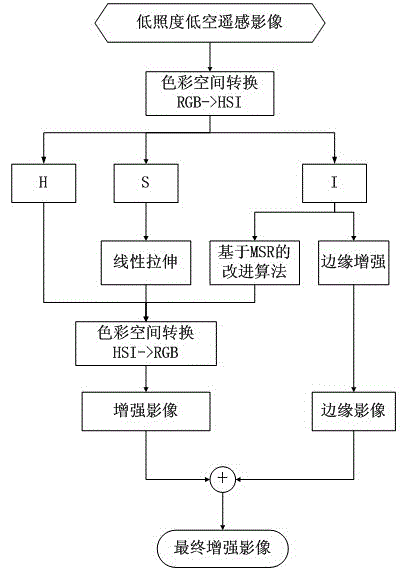
[0028] The present invention will be further described below in conjunction with the accompanying drawings and embodiments. The technical solution of the present invention can adopt computer software technology to realize the automatic operation process. The embodiment of the present invention is to enhance the low-light and low-altitude remote sensing images of Futian District, Shenzhen City, referring to figure 1 , the concrete steps of the embodiment of the present invention are as follows:
[0029] Step 1: Convert the original image from RGB color space to HSI color space.
[0030] For the low-illuminance and low-altitude remote sensing image input as the original image, the main purpose of the present invention is to convert the original image from the RGB color space to the HSI color space for enhancement processing to separate the color component from the brightness component and saturation component, so as to ensure that the color component does not Change, adjust th...
PUM
 Abstract
Description
Claims
Application Information
 - R&D
- Intellectual Property
- Life Sciences
- Materials
- Tech Scout
- Unparalleled Data Quality
- Higher Quality Content
- 60% Fewer Hallucinations
Browse by: Latest US Patents, China's latest patents, Technical Efficacy Thesaurus, Application Domain, Technology Topic, Popular Technical Reports.
© 2025 PatSnap. All rights reserved.Legal|Privacy policy|Modern Slavery Act Transparency Statement|Sitemap|About US| Contact US: help@patsnap.com


